Arquivo da tag: Desastre

Menos de 3% das multas ambientais cobradas no Brasil são pagas (El País)

DESASTRE EM MARIANA »

Empresas poluidoras ou responsáveis por desastres protelam pagamento por meio judicial

 /  

Brasília / São Paulo 21 NOV 2015 – 13:43 BRST

Localidade de Bento Rodrigues devastada após rompimento de barragem. / ROGÉRIO ALVES (FOTOS PÚBLICAS)

De cada 100 reais em multas aplicadas pelo Instituto Brasileiro de Meio Ambiente (Ibama) desde 2011 para quem infringiu regras ambientais, menos de três reais entraram nos caixas do Governo federal. Os dados constam de um relatório do órgão que é entregue ao Tribunal de Contas da União (TCU) anualmente. Entre janeiro 2011 e setembro de 2015, foram aplicados 16,5 bilhões de reais em punições, por exemplo, a empresas que emitiram gases poluidores acima do limite aceitável, petroleiras responsáveis por derramamento de óleo no mar ou madeireiras que desmataram áreas proibidas, entre outros. Desse valor, apenas 494,2 milhões acabaram sendo efetivamente pagos pelas empresas infratoras.

O assunto ganha fôlego depois do acidente de Mariana que matou aos menos 11 pessoas, número que pode subir para 23, uma vez que outras 12 estão desaparecidas. No cálculo do Ibama ainda não está relacionada a multa de 250 milhões de reais aplicada à mineradora Samarco, responsável pelo desastre na cidade mineira de Mariana e no rio Doce, que atinge os Estados de Minas Gerais e o Espírito Santo. O rompimento de uma barragem desta mineradora, que é controlada pela Vale, a maior mineradora do Brasil, e pela australiana BHP (a maior do mundo), resultou em um tsunami de lama que devastou ao menos três municípios mineiros e já alcançou o estado do Espírito Santo.

Entre os motivos para se ter uma arrecadação tão baixa, em comparação com os valores de multas aplicados, é o excesso de recursos judiciais a que tem direito as companhias. Quando uma empresa recebe um auto de infração ela tem ao menos duas instâncias administrativas para recorrer dentro do próprio Ibama. Além disso, pode buscar um aparo do Judiciário para evitar ou protelar o pagamento.

O baixo número de autoridades julgadoras das ações administrativas – hoje são sete servidores com essa função nas últimas instâncias, em Brasília, para analisar cerca de 14.000 casos anuais –, também colabora para a lentidão nos julgamentos. Conforme fontes do Ibama, na área administrativa, um processo leva até três anos para ser concluído. Ou seja, com mais recursos financeiros, as empresas colocam seus advogados para brecar as punições com mais velocidade que os fiscais podem empregar para cobrar respeito à legislação. Assim, o Governo fica atrás com um funil para lidar com as agressões ao meio ambiente, que podem desembocar em tragédias como a de Mariana. A lentidão levou a milhares de crimes prescritos entre 2012 e 2013, quando 8.580 processos perderam o prazo legal para condenar os autores das infrações, segundo o relatório de gestão entregue ao TCU.

O Ibama tem defendido mudanças nas regras ambientais para alterar o limite de 50 milhões de reais.

Há um esforço pela melhoria desse quadro há alguns anos. Em 2013, por exemplo, a média de tempo para a conclusão da análise de um auto de infração era de quatro anos e três meses. Em 2012, cinco anos e sete meses.

Os dados dos relatórios obtidos pelo EL PAÍS somados ao, em alguns casos, reduzido valor da multa em comparação com o tamanho do dano ambiental  – o teto das multas no Brasil é de 50 milhões de reais – implicam na precipitada sensação de impunidade. Ocorre que as multas não são o único instrumento para punir as empresas poluidoras ou responsáveis por desmatamentos. Para interferir no patrimônio das infratoras, o Ibama pode sugerir o embargo, a interdição ou a suspensão do registro de funcionamento. Sem poder funcionar, ela não consegue fazer o dinheiro circular e, algumas vezes, se vê forçada a pagar as multas e se adequar às regras ambientais. Isso tem ocorrido com frequência em relação às madeireiras que atuam principalmente na Amazônia.

Uma outra frente é inscrever as infratoras no Cadastro dos Inadimplentes do Governo Federal (Cadin). Uma vez com o nome sujo, as empresas não podem assinar contratos com a União nem obter uma série de benefícios como isenções fiscais ou créditos em bancos públicos.

Mas, quando se compara o valor da multa inicial da Samarco (250 milhões de reais, somando cinco infrações, que vão da poluição dos rios ao lançamento de resíduos danosos à biodiversidade) com a paga pela British Petroleum, por exemplo, de 20,7 bilhões de reais pelo vazamento de petróleo no Golfo do México em 2010, a impressão é que o Brasil precisa ser mais rigoroso no assunto.

O Ibama tem defendido mudanças nas regras ambientais para alterar o limite de 50 milhões de reais. Na última quarta-feira, em uma audiência na Câmara dos Deputados que discutiu o desastre de Mariana, o diretor de proteção ambiental do órgão, Luciano Evaristo, externou essa posição do instituto. “Quando se limita uma autuação a 50 milhões de reais, o empreendedor que tem um custo de 500 milhões de reais para segurança vai preferir deixar tudo cair, porque o valor da multa será menor. Temos que rever esse valor máximo”, afirmou.

Apesar do valor das multas aplicadas pelo Ibama parecer pequeno diante do dano causado pela tragédia, o presidente da Comissão de Direito Ambiental da OAB Minas, Mário Werneck, ressalta que não se pode confundir essa penalidade com a indenização total que a Samarco terá que pagar. “Só com a finalização da ação civil pública será possível mensurar o que terá que ser repassado pela empresa para a recuperação ambiental da região afetada e a reparação dos danos às vítimas”, explica Mário Werneck.

“O que acontece aqui é que temos apenas 4 fiscais, estamos em cima de uma bomba atômica em Minas Gerais”. – Presidente da Comissão de Direito Ambiental da OAB Minas, Mário Wernek

Nesta quarta-feira, a mineradora recebeu uma nova notificação de multa. Dessa vez ,ela foi notificada pela Subsecretaria Estadual de Fiscalização de Meio Ambiente de Minas, que penalizou a mineradora em 112, 69 milhões de reais pelos danos ambientais causados pelo rompimento da Barragem Fundão, no início do mês. A Samarco confirmou o recebimento da notificação e terá o prazo de até 20 dias do recebimento do auto de infração para pagar a multa ou apresentar a defesa.

A pressão sobre a mineradora deve crescer com uma ação conjunta que deve ser impetrada pelo Governo de Minas Gerais e Espírito Santo na Justiça, segundo informa o O Estado de S. Paulo deste sábado. O governador capixaba Paulo Hartung afirmou ao jornal que um processo do gênero foi adotado nos Estados Unidos pelos Estados atingidos pelo vazamento da BP em 2010. O desastre de Mariana ganhou a boca do povo no Brasil e a cobrança por uma punição tem sido crescente. Nesta sexta, o vocalista da banda Pearl Jam, Eddie Vedder, que se apresentava em Belo Horizonte, capital mineira, leu um texto em português para falar do desastre de Mariana. “Esperamos que eles sejam punidos, duramente punidos para que nunca esqueçam o triste desastre causado por eles”, disse ele, para delírio da plateia.

Multas anistiadas

Com um programa de concessões em infraestrutura lançado este ano, que prevê investimentos de até 200 bilhões de reais, o Governo brasileiro deve ser cada vez mais cobrado por uma legislação ambiental eficiente diante dos problemas que tendem a surgir nesses empreendimentos. Atualmente, além das multas ambientais não serem pagas pela maioria das empresas, algumas infrações são anistiadas por falta de recursos para bancar os custos dos processos judiciais. Em agosto, o governador mineiro, Fernando Pimentel (PT), sancionou uma lei que permite ao Sistema Estadual do Meio Ambiente e Recursos Hídricos (Sisema) anistiar multas ambientais de até 15.000 reais que foram emitidas até o fim de 2012. A medida também será aplicada para infrações de até 5.000 reais que foram notificadas em 2013 e 2014 e deve anistiar cerca de 120 mil multas.

“Um processo de cobrança judicial, hoje, para o Estado de Minas Gerais, custa em torno de 16 mil reais, segundo cálculos da Advocacia Geral do Estado. Qualquer cobrança de crédito abaixo desse valor significa que o Estado paga para receber”, explicou o secretário de Estado do Meio Ambiente e Desenvolvimento Sustentável, Sávio Souza Cruz por meio de nota enviada pelo Sisema.

Werneck é contra a medida já que, segundo ele, muitas empresas já deixam de pagar porque sabem que serão anistiadas. “Se eu aplico multas elas precisam ser cobradas, mas a verdade é que não há um corpo técnico para atuar. Se eles resgatassem essas multas poderiam inclusive aumentar o pessoal, a fiscalização. É um absurdo”, explica.

Para o presidente da Comissão de Direito Ambiental da OAB Minas, Mário Werneck, é preciso estudar um novo modelo de barragem e aplicar uma maior fiscalização da atividade já que, segundo ele, Minas Gerais possui 450 barragens de rejeitos e 45 delas estão com as licenças desatualizadas, à espera de revalidação. “Mas o que acontece aqui é que temos apenas quatro fiscais. Estamos em cima de uma bomba atômica em Minas Gerais”.

MAIS INFORMAÇÕES

Preventing famine with mobile phones (Science Daily)

Date: November 19, 2015

Source: Vienna University of Technology, TU Vienna

Summary: With a mobile data collection app and satellite data, scientists will be able to predict whether a certain region is vulnerable to food shortages and malnutrition, say experts. By scanning Earth’s surface with microwave beams, researchers can measure the water content in soil. Comparing these measurements with extensive data sets obtained over the last few decades, it is possible to calculate whether the soil is sufficiently moist or whether there is danger of droughts. The method has now been tested in the Central African Republic.


Does drought lead to famine? A mobile app helps to collect information. Credit: Image courtesy of Vienna University of Technology, TU Vienna

With a mobile data collection app and satellite data, scientists will be able to predict whether a certain region is vulnerable to food shortages and malnutrition. The method has now been tested in the Central African Republic.

There are different possible causes for famine and malnutrition — not all of which are easy to foresee. Drought and crop failure can often be predicted by monitoring the weather and measuring soil moisture. But other risk factors, such as socio-economic problems or violent conflicts, can endanger food security too. For organizations such as Doctors without Borders / Médecins Sans Frontières (MSF), it is crucial to obtain information about vulnerable regions as soon as possible, so that they have a chance to provide help before it is too late.

Scientists from TU Wien in Vienna, Austria and the International Institute for Applied Systems Analysis (IIASA) in Laxenburg, Austria have now developed a way to monitor food security using a smartphone app, which combines weather and soil moisture data from satellites with crowd-sourced data on the vulnerability of the population, e.g. malnutrition and other relevant socioeconomic data. Tests in the Central African Republic have yielded promising results, which have now been published in the journal PLOS ONE.

Step One: Satellite Data

“For years, we have been working on methods of measuring soil moisture using satellite data,” says Markus Enenkel (TU Wien). By scanning Earth’s surface with microwave beams, researchers can measure the water content in soil. Comparing these measurements with extensive data sets obtained over the last few decades, it is possible to calculate whether the soil is sufficiently moist or whether there is danger of droughts. “This method works well and it provides us with very important information, but information about soil moisture deficits is not enough to estimate the danger of malnutrition,” says IIASA researcher Linda See. “We also need information about other factors that can affect the local food supply.” For example, political unrest may prevent people from farming, even if weather conditions are fine. Such problems can of course not be monitored from satellites, so the researchers had to find a way of collecting data directly in the most vulnerable regions.

“Today, smartphones are available even in developing countries, and so we decided to develop an app, which we called SATIDA COLLECT, to help us collect the necessary data,” says IIASA-based app developer Mathias Karner. For a first test, the researchers chose the Central African Republic- one of the world’s most vulnerable countries, suffering from chronic poverty, violent conflicts, and weak disaster resilience. Local MSF staff was trained for a day and collected data, conducting hundreds of interviews.

“How often do people eat? What are the current rates of malnutrition? Have any family members left the region recently, has anybody died? — We use the answers to these questions to statistically determine whether the region is in danger,” says Candela Lanusse, nutrition advisor from Doctors without Borders. “Sometimes all that people have left to eat is unripe fruit or the seeds they had stored for next year. Sometimes they have to sell their cattle, which may increase the chance of nutritional problems. This kind of behavior may indicate future problems, months before a large-scale crisis breaks out.”

A Map of Malnutrition Danger

The digital questionnaire of SATIDA COLLECT can be adapted to local eating habits, as the answers and the GPS coordinates of every assessment are stored locally on the phone. When an internet connection is available, the collected data are uploaded to a server and can be analyzed along with satellite-derived information about drought risk. In the end a map could be created, highlighting areas where the danger of malnutrition is high. For Doctors without Borders, such maps are extremely valuable. They help to plan future activities and provide help as soon as it is needed.

“Testing this tool in the Central African Republic was not easy,” says Markus Enenkel. “The political situation there is complicated. However, even under these circumstances we could show that our technology works. We were able to gather valuable information.” SATIDA COLLECT has the potential to become a powerful early warning tool. It may not be able to prevent crises, but it will at least help NGOs to mitigate their impacts via early intervention.


Story Source:

The above post is reprinted from materials provided by Vienna University of Technology, TU ViennaNote: Materials may be edited for content and length.


Journal Reference:

  1. Markus Enenkel, Linda See, Mathias Karner, Mònica Álvarez, Edith Rogenhofer, Carme Baraldès-Vallverdú, Candela Lanusse, Núria Salse. Food Security Monitoring via Mobile Data Collection and Remote Sensing: Results from the Central African RepublicPLOS ONE, 2015; 10 (11): e0142030 DOI: 10.1371/journal.pone.0142030

Áreas de alto e muito alto risco (IPT)

Instituto de Pesquisas Tecnológicas assina contrato com Defesa Civil de SP para identificação de áreas de deslizamentos e inundações em 10 cidades

Um novo contrato assinado entre o Instituto de Pesquisas Tecnológicas (IPT) e a Coordenaria Estadual de Defesa Civil do Estado de São Paulo prevê o mapeamento das áreas de alto e muito alto risco a deslizamentos e inundações em 10 municípios. A relação contempla os municípios que apresentaram incidência e recorrência de eventos de ordem meteorológica, hidrológica e geológica, de acordo com dados estatísticos registrados no Sistema Integrado de Defesa Civil (SIDEC) e que ainda não possuem instrumentos de identificação de risco abrangidos no Plano Preventivo de Defesa Civil do estado.

O projeto de três meses será realizado pela Seção de Investigações, Riscos e Desastres Naturais do IPT por meio de visitas técnicas aos municípios e posterior organização das informações em mapas, imagens e documentação fotográfica em um Sistema de Informações Geográficas (SIG), a fim de subsidiar o gerenciamento das áreas e estabelecer parâmetros técnicos e sociais.

Os graus de risco considerados seguem o método desenvolvido em 2007 pelo Ministério das Cidades e IPT, o qual estabelece quatro condições potenciais de risco – “é importante ressaltar que o projeto tratará dos setores classificados como de risco alto (R3) e muito alto (R4) das 10 cidades”, afirma Marcelo Fischer Gramani, coordenador do projeto e pesquisador da Seção.

As cidades incluídas no projeto estão localizadas nas Regiões Administrativas de Presidente Prudente (Adamantina, Caiabu, Inúbia Paulista e Presidente Prudente), de Campinas (Caconde e Divinolândia), de Itapeva (Paranapanema e Tejupá), de Marília (Tupã) e de Barretos (Olímpia). Estes municípios foram indicados como prioritários por não terem informações atualizadas sobre riscos de deslizamento e/ou inundações.

As principais atividades desenvolvidas pelo IPT incluem a pesquisa bibliográfica dos levantamentos de áreas de riscos existentes, a consulta às equipes das Coordenadorias Municipais de Defesa Civil sobre o número de atendimentos efetuados nos locais que serão avaliados, a realização de vistorias de campo para levantamento de indicadores de risco e tipologias dos processos, e a elaboração de documentação fotográfica.

Os dados coletados serão analisados para fundamentar o relatório técnico, que irá conter informações como descrição da área avaliada, delimitação dos setores de risco identificados em imagem de sensores remotos, quantidade de imóveis em risco, quantidade de pessoas em risco, tipologia do processo (deslizamento, inundação, solapamento de margem) e sugestões de intervenções para minimizar ou eliminar os riscos identificados.

(IPT)

Força do El Niño deve agravar a seca que atinge o semiárido, diz Cemaden (Cemaden)

Relatório divulgado nesta quarta-feira (18) aponta para cenário de poucas chuvas no Nordeste entre fevereiro e maio de 2016. Seca atinge 910 municípios e um milhão de propriedades da agricultura familiar

Relatório divulgado nesta quarta-feira (18) pelo Centro Nacional de Monitoramento e Alertas de Desastres Naturais (Cemaden/MCTI) aponta para um cenário de poucas chuvas na região Nordeste entre fevereiro e maio de 2016, o que deve agravar os impactos da seca que atinge a região.

Relatório da Situação Atual da Seca e Impactos no Semiárido do País também revela que choveu pouco nos últimos 90 dias, sobretudo, no Maranhão, sul da Bahia, e norte de Minas Gerais e Espírito Santo. Ainda que neste período sejam esperados índices pluviométricos mais baixos, nos últimos meses os acumulados foram abaixo da média. Segundo o Cemaden, a causa é o fenômeno El Niño, que está mais forte.

“A avaliação das condições climáticas de grande escala mostra que o fenômeno El Niño está presente, intenso e em franco desenvolvimento. Sob este condicionante, no trimestre novembro-dezembro de 2015 e janeiro de 2016, há chances mínimas de reverter o quadro crítico, apontado pelo indicador de risco agroclimático. Outra indicação decorrente deste cenário climático, altamente provável, é que já se pode inferir que a próxima estação chuvosa do norte do Nordeste (de fevereiro a maio de 2016) apresente condições de deficiência de precipitação”, diz o documento.

Cerca de um milhão de propriedades da agricultura familiar estão localizadas nas áreas afetadas pela seca, em 910 municípios. De acordo com o índice VSWI (sigla em inglês para Índice de Vegetação de Abastecimento de Água), indicador de seca agrícola, esses municípios apresentam pelo menos 50% de suas áreas agrícolas ou de pastagens em condições de déficit hídrico.

Monitoramento

De acordo com a Resolução Nº 13, de 22 de maio de 2014 do Ministério da Integração Nacional e, posteriormente, com o Decreto Presidencial Nº 8.472, de 22 de junho de 2015, o Cemaden/MCTI tem a responsabilidade de fornecer informações para as ações emergenciais adotadas pelo governo para mitigar os impactos da seca. Assim, além do monitoramento da seca, o Cemaden desenvolve um sistema de alerta de riscos de colapso de safras para a agricultura familiar do semiárido.

(Cemaden)

Acidente em Mariana é o maior da História com barragens de rejeitos (Jornal da Ciência)

Volume de material despejado é duas vezes e meia superior ao segundo maior

A tragédia de Mariana é o maior acidente da História em volume de material despejado por barragens de rejeitos de mineração. Os 62 milhões de metros cúbicos de lama que vazaram dos depósitos da Samarco no dia 5 representam uma quantidade duas vezes e meia maior que o segundo pior acidente do gênero, ocorrido em 4 de agosto de 2014 na mina canadense de Mount Polley, na Colúmbia Britânica, diz o pesquisador Marcos Freitas, coordenador executivo do Instituto Virtual Internacional de Mudanças Globais (Ivig), ligado à Coppe/UFRJ.

Leia na íntegra: O Globo

Leia também:

O Estado de S. Paulo – Dilma diz que será criado fundo para áreas afetadas por lama

O Estado de Minas – Samarco admite que barragens correm risco de rompimento; chuva agrava situação

Mudança climática pode reduzir capacidade hidrelétrica em até 20% (Estadão)

Giovana Girardi

29 de outubro de 2015

Temperaturas mais elevadas, mudança no regime de chuvas e aumento de eventos climáticos extremos são apenas uma parte da história das mudanças climáticas. A forma como essas mudanças vão impactar agricultura, geração de energia, infraestrutura, oferta d’água e saúde é o outrolado que acaba de ganhar detalhes para o Brasil.

Considerado o mais importante estudo sobre como diversos setores vão reagir diante do clima modificado, o projeto Brasil 2040 – Alternativas de Adaptação às Mudanças Climáticas foi publicado ontem no site da extinta Secretaria de Assuntos Estratégicos(SAE) da Presidência.

Um dos principais resultados é sobre como a oferta de água será afetada. As regiões Norte, Nordeste e Centro-Oeste do Brasil deverão sofrer redução. A Sul pode ter um leve aumento na média, mas com uma distribuição muito irregular. Para o Sudeste, há incertezas. Isso pode ter impactos diretos na agricultura e na energia.

Usina hidrelétrica Belo Monte, no pior cenário de mudanças climáticas, pode ser afetada por falta de chuvas e deixar de compensar financeiramente

Usina hidrelétrica Belo Monte, no pior cenário de mudanças climáticas, pode ser afetada por falta de chuvas e deixar de compensar financeiramente

Diversos grupos de pesquisa do Brasil trabalharam com dados de dois modelos climáticos, que, por sua vez, levaram em conta dois cenários do IPCC (o painel da ONU de cientistas do clima). Um, mais pessimista, que considera que o mundo não vai agir para combater as mudanças climáticas, e um intermediário, que imagina que haverá algumas ações, mas não o suficiente, e o mundo ainda vai aquecer pelo menos 3°C. Este segundo cenário é condizente com as propostas de redução das emissões apresentadas como contribuição para a Conferência do Clima de Paris.

No pior cenário, até 2040 a capacidade das hidrelétricas pode ficar de 8% a 20% menor. Já no melhor cenário, a capacidade diminui entre 4% e 15%. Ou seja, mesmo se o mundo fizer tudo o que está prometendo para combater o aquecimento global, ainda podemos ter impacto na produção de energia. Usinas na Amazônia como a de Belo Monte ou o novo projeto pensado para o rio Tapajós seriam inviabilizados.

Hoje o Brasil ainda é altamente dependente da água para a geração de energia elétrica. Cerca de 80% vêm de hidrelétricas. “O que por um lado torna a matriz energética brasileira mais limpa que a média mundial, por outro a torna vulnerável se o clima mudar”, afirma Roberto Schaeffer, da UFRJ, coordenador do capítulo de energia.

O gargalo, principalmente nas hidrelétricas localizadas na Amazônia, é que elas não têm reservatórios. Com isso, não têm estoque de água na seca. “Essa vulnerabilidade que a mudança climática traz talvez nos faça repensar se não é melhor voltar a ter hidrelétricas com reservatório”, complementa.

O Brasil pode ficar mais dependente de térmicas. O estudo até prevê um aumento das energias eólica (no Nordeste) e solar (Sul e Sudeste), mas como elas são intermitentes, há necessidade de ter uma energia de base e, se a hidrelétrica falhar, as térmicas serão a saída. “Mas pode ser a etanol, a bagaço de cana, a biomassa, não a carvão”, sugere Schaeffer. “O ideal é ter diversidade. E planejar a expansão do setor incorporando a variável das mudanças climáticas. Não podemos mais só olhar para as séries hidrológicas do passado para prever o futuro, porque ele será bem diferente.”

Soja em risco. A mudança no regime hídrico pode trazer impactos também às principais commodities agrícolas do Brasil. A redução de área potencial para lavouras pode ser de até 39,3%, no pior cenário. A soja seria a cultura mais afetada, tendo uma perda de até 67% da área plantada na região Sul até 2040.

Produtor rural mostra área afetada pela estiagem em sua plantação de soja, em Santa Maria (RS), em crise de 2012. Falta de chuva no período de plantio pode levar a uma perda de área para o plantio do grão no Estado

Produtor rural mostra área afetada pela estiagem em sua plantação de soja, em Santa Maria (RS), em crise de 2012. Falta de chuva no período de plantio pode levar a uma perda de área para o plantio do grão no Estado

De acordo com Leila Harfuch, do Agroicone, no entanto, áreas do Centro-Oeste e do Norte podem compensar parte dessa perda. Na comparação com um futuro sem mudança do clima, a perda total de área de soja no País seria de 5%.

“Existe uma dinâmica econômica que torna o impacto nacional menos dramática, vai haver uma realocação da produção no caso dos grãos. Mas os impactos locais serão muito relevante, em especial para a região Sul. Vai ter perda de valor de produção, de emprego e renda, mas em termos produtivos, outras regiões podem compensar”, explica Leila.

Segundo ela, algo parecido pode acontecer com as plantações de cana-de-açúcar na região Sudeste. A estimativa, no pior cenário, é de redução de 10% na área plantada na região na comparação com o tamanho que a produção teria se não houvesse mudanças climáticas. Parte seria compensada no Sul e parte no Centro-Oeste.

Segundo o estudo, quem mais deve perder área é a pastagem. Não necessariamente porque o clima prejudique muito o pasto, mas porque tanto áreas degradadas quanto outras que tenham aptidão para a agricultura poderão ser ocupadas com grãos. Está esperada uma queda de 6,5% da área ocupada pela pecuária, mas o estudo espera que haja uma intensificação da produção, de modo que ela deve se manter estável.

Repercussão. O Observatório do Clima, coalizão brasileira com mais de 30 organizações da sociedade civil em torno das mudanças climáticas, afirmou que o estudo tem de servir como alerta para que o Brasil deixe a tratar o problema como um tema marginal.

“O estudo traça um panorama preocupante dos impactos das mudanças climáticas sobre a economia nacional já nos próximos 25 anos. Mostra que a maneira como o Brasil investe em agropecuária e em infraestrutura precisa ser radicalmente revista. Grandes hidrelétricas na Amazônia, como Belo Monte e São Luís do Tapajós, poderão ter reduções importantes de vazão, e a sociedade pode acabar enterrando bilhões de reais em obras que não se pagam”, afirmou Carlos Rittl, secretário-executivo da organização. Para ele, o estudo “aponta a necessidade de o Brasil lutar por um acordo do clima ambicioso nas próximas semanas na conferência de Paris, e de aumentar também a ambição da própria proposta.”

Dudas sobre El Niño retrasan preparación ante desastres (SciDev Net)

Dudas sobre El Niño retrasan preparación ante desastres

Crédito de la imagen: Patrick Brown/Panos

27/10/15

Martín De Ambrosio

De un vistazo

  • Efectos del fenómeno aún son confusos a lo largo del continente
  • No hay certeza, pero cruzarse de brazos no es opción, según Organización Panamericana de la Salud
  • Hay consenso científico del 95 por ciento sobre posibilidades de un El Niño fuerte

Los desacuerdos que existen entre los científicos sobre la posibilidad de que Centro y Sudamérica sufran o no un fuerte evento El Niño están generando cierto retraso en las preparaciones, según advierten las principales organizaciones que trabajan en el clima de la región.

Algunos investigadores sudamericanos aún tienen dudas sobre la forma cómo se desarrolla el evento este año. Esta incertidumbre impacta en los funcionarios y los estados, que deberían actuar cuanto antes para prevenir los peores escenarios, incluyendo muertes debido a desastres naturales, reclaman las organizaciones meteorológicas.

Eduardo Zambrano, investigador del Centro de Investigación Internacional sobre el Fenómeno de El Niño (CIIFEN) en Ecuador, y uno de los centros regionales de la Organización Meteorológica Mundial, dice que el problema es que los efectos del fenómeno todavía no han sido claros y evidentes en todo el continente.

“Algunas imágenes de satélite nos muestran un Océano Pacífico muy caliente, una de las características de El Niño”.

Willian Alva León, presidente de la Sociedad Meteorológica del Perú

“De todos modos podemos hablar sobre las extremas sequías en el noreste de Brasil, Venezuela y la zona del Caribe”, dice, y menciona además las inusualmente fuertes lluvias en el desierto de Atacama en Chile desde marzo y las inundaciones en zonas de Argentina, Uruguay y Paraguay.

El Niño alcanza su pico cuando una masa de aguas cálidas para los habituales parámetros del este del Océano Pacífico, se mueve de norte a sur y toca costas peruanas y ecuatorianas. Este movimiento causa efectos en cascada y estragos en todo el sistema de América Central y del Sur, convirtiendo las áridas regiones altas en lluviosas, al tiempo que se presentan sequías en las tierras bajas y tormentas sobre el Caribe.

Pero El Niño continúa siendo de difícil predicción debido a sus muy diferentes impactos. Los científicos, según Zambrano, esperaban al Niño el año pasado “cuando todas las alarmas sonaron, y luego no pasó nada demasiado extraordinario debido a un cambio en la dirección de los vientos”.

Tras ese error, muchas organizaciones prefirieron la cautela para evitar el alarmismo. “Algunas imágenes de satélite nos muestran un Océano Pacífico muy caliente, una de las características de El Niño”, dice Willian Alva León, presidente de la Sociedad Meteorológica del Perú. Pero, agrega, este calor no se mueve al sudeste, hacia las costas peruanas, como sucedería en caso del evento El Niño.

Alva León cree que los peores efectos ya sucedieron este año, lo que significa que el fenómeno está en retirada. “El Niño tiene un límite de energía y creo que ya ha sido alcanzado este año”, dice.

Este desacuerdo entre las instituciones de investigación del clima preocupa a quienes generan políticas, pues necesitan guías claras para iniciar las preparaciones necesarias del caso. Ciro Ugarte, asesor regional del área de Preparativos para Emergencia y Socorro en casos de Desastrede la Organización Panamericana de la Salud, dice que es obligatorio actuar como si El Niño en efecto estuviera en proceso para asegurar que el continente enfrente las posibles consecuencias.

“Estar preparados es importante porque reduce el impacto del fenómeno así como otras enfermedades que hoy son epidémicas”, dice.

Para asegurar el grado de probabilidad de El Niño, algunos científicos usan modelos que abstraen datos de la realidad y generan predicciones. María Teresa Martínez, subdirectora de meteorología del Instituto de Hidrología, Meteorología y Estudios Ambientales de Colombia, señala que los modelos más confiables predijeron en marzo que había entre un 50 y un 60 por ciento de posibilidad de un evento El Niño. “Ahora El Niño se desarrolla con fuerza desde su etapa de formación hacia la etapa de madurez, que será alcanzada en diciembre”, señala.

Ugarte admite que no hay certezas, pero dice que para su organización “no hacer nada no es una opción”.

“Como creadores de políticas de prevención, lo que tenemos que hacer es usar lo que es el consenso entre los científicos, y hoy ese consenso dice que hay un 95% de posibilidades de tener un fuerte o muy fuerte evento El Niño”, dice.

Extreme weather: Is it all in your mind? (USA Today)

Thomas M. Kostigen, Special for USA TODAY9:53 a.m. EDT October 17, 2015

Weather is not as objective an occurrence as it might seem. People’s perceptions of what makes weather extreme are influenced by where they live, their income, as well as their political views, a new study finds.

There is a difference in both seeing and believing in extreme weather events, according to the study in the journal Environmental Sociology.

“Odds were higher among younger, female, more educated, and Democratic respondents to perceive effects from extreme weather than older, male, less educated, and Republican respondents,” said the study’s author, Matthew Cutler of the University of New Hampshire.

There were other correlations, too. For example, people with lower incomes had higher perceptions of extreme weather than people who earned more. Those who live in more vulnerable areas, as might be expected, interpret the effects of weather differently when the costs to their homes and communities are highest.

Causes of extreme weather and the frequency of extreme weather events is an under-explored area from a sociological perspective. Better understanding is important to building more resilient and adaptive communities. After all, why prepare or take safety precautions if you believe the weather isn’t going to be all that bad or occur all that often?

The U.S. Climate Extremes Index, compiled by the National Oceanic and Atmospheric Administration (NOAA), shows a significant rise in extreme weather events since the 1970s, the most back-to-back years of extremes over the past decade since 1910, and all-time record-high levels clocked in 1998 and 2012.

“Some recent research has demonstrated linkages between objectively measured weather, or climate anomalies, and public concern or beliefs about climate change,” Cutler notes. “But the factors influencing perceptions of extreme or unusual weather events have received less attention.”

Indeed, there is a faction of the public that debates how much the climate is changing and which factors are responsible for such consequences as global warming.

Weather, on the other hand, is a different order of things: it is typically defined in the here and now or in the immediate future. It also is largely confined, because of its variability, to local or regional areas. Moreover, weather is something we usually experience directly.

Climate is a more abstract concept, typically defined as atmospheric conditions over a 30-year period.

When weather isn’t experiential, reports are relied upon to gauge extremes. This is when beliefs become more muddied.

“The patterns found in this research provide evidence that individuals experience extreme weather in the context of their social circumstances and thus perceive the impacts of extreme weather through the lens of cultural and social influences. In other words, it is not simply a matter of seeing to believe, but rather an emergent process of both seeing and believing — individuals experiencing extreme weather and interpreting the impacts against the backdrop of social and economic circumstances central to and surrounding their lives,” Cutler concludes.

Sophocles said, “what people believe prevails over the truth.” The consequences of disbelief come at a price in the context of extreme weather, however, as damage, injury, and death are often results.

Too many times do we hear about people being unprepared for storms, ignoring officials’ warnings, failing to evacuate, or engaging in reckless behavior during weather extremes.

There is a need to draw a more complete picture of “weather prejudice,” as I’ll call it, in order to render more practical advice about preparing, surviving, and recovering from what is indisputable: extreme weather disasters to come.

Thomas M. Kostigen is the founder of TheClimateSurvivalist.com and a New York Times bestselling author and journalist. He is the National Geographic author of “The Extreme Weather Survival Guide: Understand, Prepare, Survive, Recover” and the NG Kids book, “Extreme Weather: Surviving Tornadoes, Tsunamis, Hailstorms, Thundersnow, Hurricanes and More!” Follow him @weathersurvival, or email kostigen@theclimatesurvivalist.com.

Aquecimento pode triplicar seca na Amazônia (Observatório do Clima)

15/10/2015

 Seca em Silves (AM) em 2005. Foto: Ana Cintia Gazzelli/WWF

Seca em Silves (AM) em 2005. Foto: Ana Cintia Gazzelli/WWF

Modelos de computador sugerem que leste amazônico, que contém a maior parte da floresta, teria mais estiagens, incêndios e morte de árvores, enquanto o oeste ficaria mais chuvoso.

As mudanças climáticas podem aumentar a frequência tanto de secas quanto de chuvas extremas na Amazônia antes do meio do século, compondo com o desmatamento para causar mortes maciças de árvores, incêndios e emissões de carbono. A conclusão é de uma avaliação de 35 modelos climáticos aplicados à região, feita por pesquisadores dos EUA e do Brasil.

Segundo o estudo, liderado por Philip Duffy, do WHRC (Instituto de Pesquisas de Woods Hole, nos EUA) e da Universidade Stanford, a área afetada por secas extremas no leste amazônico, região que engloba a maior parte da Amazônia, pode triplicar até 2100. Paradoxalmente, a frequência de períodos extremamente chuvosos e a área sujeita a chuvas extremas tende a crescer em toda a região após 2040 – mesmo nos locais onde a precipitação média anual diminuir.

Já o oeste amazônico, em especial o Peru e a Colômbia, deve ter um aumento na precipitação média anual.

A mudança no regime de chuvas é um efeito há muito teorizado do aquecimento global. Com mais energia na atmosfera e mais vapor d’água, resultante da maior evaporação dos oceanos, a tendência é que os extremos climáticos sejam amplificados. As estações chuvosas – na Amazônia, o período de verão no hemisfério sul, chamado pelos moradores da região de “inverno” ficam mais curtas, mas as chuvas caem com mais intensidade.

No entanto, a resposta da floresta essas mudanças tem sido objeto de controvérsias entre os cientistas. Estudos da década de 1990 propuseram que a reação da Amazônia fosse ser uma ampla “savanização”, ou mortandade de grandes árvores, e a transformação de vastas porções da selva numa savana empobrecida.

Outros estudos, porém, apontaram que o calor e o CO2 extra teriam o efeito oposto – o de fazer as árvores crescerem mais e fixarem mais carbono, de modo a compensar eventuais perdas por seca. Na média, portanto, o impacto do aquecimento global sobre a Amazônia seria relativamente pequeno.

Ocorre que a própria Amazônia encarregou-se de dar aos cientistas dicas de como reagiria. Em 2005, 2007 e 2010, a floresta passou por secas históricas. O resultado foi ampla mortalidade de árvores e incêndios em florestas primárias em mais de 85 mil quilômetros quadrados. O grupo de Duffy, também integrado por Paulo Brando, do Ipam (Instituto de Pesquisa Ambiental da Amazônia), aponta que de 1% a 2% do carbono da Amazônia foi lançado na atmosfera em decorrência das secas da década de 2000. Brando e colegas do Ipam também já haviam mostrado que a Amazônia está mais inflamável, provavelmente devido aos efeitos combinados do clima e do desmatamento.

Os pesquisadores simularam o clima futuro da região usando os modelos do chamado projeto CMIP5, usado pelo IPCC (Painel Intergovernamental sobre Mudança Climática) no seu último relatório de avaliação do clima global. Um dos membros do grupo, Chris Field, de Stanford, foi um dos coordenadores do relatório – foi também candidato à presidência do IPCC na eleição realizada na semana passada, perdendo para o coreano Hoesung Lee.

Os modelos de computador foram testados no pior cenário de emissões, o chamado RMP 8.5, no qual se assume que pouca coisa será feita para controlar emissões de gases-estufa.

Eles não apenas captaram bem a influência das temperaturas dos oceanos Atlântico e Pacífico sobre o padrão de chuvas na Amazônia – diferenças entre os dois oceanos explicam por que o leste amazônico ficará mais seco e o oeste, mais úmido –, como também mostraram nas simulações de seca futura uma característica das secas recorde de 2005 e 2010: o extremo norte da Amazônia teve grande aumento de chuvas enquanto o centro e o sul estorricavam.

Segundo os pesquisadores, o estudo pode ser até mesmo conservador, já que só levou em conta as variações de precipitação. “Por exemplo, as chuvas no leste da Amazônia têm uma forte dependência da evapotranspiração, então uma redução na cobertura de árvores poderia reduzir a precipitação”, escreveram Duffy e Brando. “Isso sugere que, se os processos relacionados a mudanças no uso da terra fossem mais bem representados nos modelos do CMIP5, a intensidade das secas poderia ser maior do que a projetada aqui.”

O estudo foi publicado na PNAS, a revista da Academia Nacional de Ciências dos EUA. (Observatório do Clima/ #Envolverde)

* Publicado originalmente no site Observatório do Clima.

Exxon’s climate lie: ‘No corporation has ever done anything this big or bad’ (The Guardian)

The truth of Exxon’s complicity in global warming must to be told – how they knew about climate change decades ago but chose to help kill our planet

Exxon refinery in Texas

By 1978 Exxon’s senior scientists were telling top management that climate change was real, caused by man, and would raise global temperatures by 2-3C. Photograph: Pat Sullivan/AP

I’m well aware that with Paris looming it’s time to be hopeful, and I’m willing to try. Even amid the record heat and flooding of the present, there are good signs for the future in the rising climate movement and the falling cost of solar.

But before we get to past and present there’s some past to be reckoned with, and before we get to hope there’s some deep, blood-red anger.

In the last three weeks, two separate teams of journalists — the Pulitzer-prize winning reporters at the website Inside Climate News and another crew composed of Los Angeles Times veterans and up-and-comers at the Columbia Journalism School — have begun publishing the results of a pair of independent investigations into ExxonMobil.

Though they draw on completely different archives, leaked documents, and interviews with ex-employees, they reach the same damning conclusion: Exxon knew all that there was to know about climate change decades ago, and instead of alerting the rest of us denied the science and obstructed the politics of global warming.

To be specific:

  • By 1978 Exxon’s senior scientists were telling top management that climate change was real, caused by man, and would raise global temperatures by 2-3C this century, which was pretty much spot-on.
  • By the early 1980s they’d validated these findings with shipborne measurements of CO2 (they outfitted a giant tanker with carbon sensors for a research voyage) and with computer models that showed precisely what was coming. As the head of one key lab at Exxon Research wrote to his superiors, there was “unanimous agreement in the scientific community that a temperature increase of this magnitude would bring about significant changes in the earth’s climate, including rainfall distribution and alterations in the biosphere”.
  • And by the early 1990s their researchers studying the possibility for new exploration in the Arctic were well aware that human-induced climate change was melting the poles. Indeed, they used that knowledge to plan their strategy, reporting that soon the Beaufort Sea would be ice-free as much as five months a year instead of the historic two. Greenhouse gases are rising “due to the burning of fossil fuels,” a key Exxon researcher told an audience of engineers at a conference in 1991. “Nobody disputes this fact.”

But of course Exxon did dispute that fact. Not inside the company, where they used their knowledge to buy oil leases in the areas they knew would melt, but outside, where they used their political and financial might to make sure no one took climate change seriously.

They helped organise campaigns designed to instil doubt, borrowing tactics and personnel from the tobacco industry’s similar fight. They funded “institutes” devoted to outright climate denial. And at the highest levels they did all they could to spread their lies.

To understand the treachery – the sheer, profound, and I think unparalleled evil – of Exxon, one must remember the timing. Global warming became a public topic in 1988, thanks to Nasa scientist James Hansen – it’s taken a quarter-century and counting for the world to take effective action. If at any point in that journey Exxon – largest oil company on Earth, most profitable enterprise in human history – had said: “Our own research shows that these scientists are right and that we are in a dangerous place,” the faux debate would effectively have ended. That’s all it would have taken; stripped of the cover provided by doubt, humanity would have gotten to work.

Instead, knowingly, they helped organise the most consequential lie in human history, and kept that lie going past the point where we can protect the poles, prevent the acidification of the oceans, or slow sea level rise enough to save the most vulnerable regions and cultures. Businesses misbehave all the time, but VW is the flea to Exxon’s elephant. No corporation has ever done anything this big and this bad.

I’m aware that anger at this point does little good. I’m aware that all clever people will say “of course they did” or “we all use fossil fuels”, as if either claim is meaningful. I’m aware that nothing much will happen to Exxon – I doubt they’ll be tried in court, or their executives sent to jail.

But nonetheless it seems crucial simply to say, for the record, the truth: this company had the singular capacity to change the course of world history for the better and instead it changed that course for the infinitely worse. In its greed Exxon helped — more than any other institution — to kill our planet.

ONU desiste de criar órgão para cuidar de refugiados climáticos (O Globo)

Ideia foi retirada do rascunho de acordo que será levado à Conferência de Paris

POR O GLOBO

Operários cruzam com o Ministro das Relações Exteriores da França, Laurent Fabius, durante sua visita ao local onde será realizada a 21ª Conferência do Clima, em Le Bourget – JACKY NAEGELEN / REUTERS

RIO — O rascunho do acordo global sobre mudanças climáticas, publicado pela Organização das Nações Unidas (ONU) na última segunda-feira, já mostra alterações feitas, aparentemente, devido a pressões de alguns países. O documento será usado como base para as negociações durante a 21ª Conferência do Clima (COP 21) em Paris, em dezembro.Porém, foi retirada do documento a ideia de se criar um organismo para ajudar as pessoas a escapar dos desastres causados pelas mudanças climáticas.

Segundo o site do jornal britânico “The Guardian”, o passo atrás aconteceu por pressão da Austrália, que vem sendo criticada por sua pouca ambição em diminuir a emissão de gases de efeito estufa. A versão anterior do acordo incluía “instalações para a coordenação dos deslocamentos causados pelas mudanças climáticas” que deveriam prover “migrações organizadas e realocações planejadas”, assim como compensações, em dinheiro, para as pessoas que necessitam deixar suas casas para escapar da elevação do nível do mar, de condições meteorológicas extremas ou se mudar por conta da destruição da agricultura local.

A Austrália, no entanto, se opôs à criação das instalações, e essa medida foi retirada do novo texto. “A Austrália não vê a criação de instalações para a coordenação dos deslocamentos causados pelo clima como a maneira mais eficaz ou eficiente de progredir em direção a uma ação internacional significativa para enfrentar os impactos das mudanças climáticas”, disse um porta-voz do Ministério das Relações Exteriores e Comércio, segundo o jornal “Guardian”. “A Austrália já está trabalhando com os nossos parceiros do Pacífico nessas questões importantes”.O país da Oceania já gastou mais de US$ 50 milhões em projetos de combate às mudanças climáticas no Pacífico e contribuiu com US$ 200 milhões para o Fundo Verde do Clima, mas vem sendo criticado por sua falta de ambição em cortar suas emissões de gases do efeito estufa e não ter um quadro político que apoie a causa de maneira consistente. O novo rascunho de 20 páginas, que substituiu outro, de 90, exortou todas as nações a se comprometerem com políticas de mitigação e endurecerem seus compromissos a cada cinco anos.

O projeto também salienta a importância da cooperação internacional e do apoio aos esforços de adaptação dos países em desenvolvimento, mais vulneráveis aos efeitos da mudança climática. O acordo ainda aponta a necessidade de todos os governos estarem engajados na causa.

Os impactos da mudanças climáticas devem deslocar até 250 milhões de pessoas em todo o mundo até 2050, incluindo muitos habitantes das ilhas do Pacífico. Em algumas áreas do Pacífico, o nível do mar está subindo 1,2 centímetros por ano, quatro vezes mais rápido do que a média global, o que é alarmante. Em ilhas a dois ou três metros acima do nível do mar, comunidades já estão sendo realocadas, e a água potável e as colheitas são constantemente ameaçadas por inundações de água salgada.

A COP 21 terá como principal objetivo costurar um novo acordo entre os países para diminuir a emissão de gases de efeito estufa, diminuindo o aquecimento global e, em consequência, limitar o aumento da temperatura global em 2ºC até 2100.

Leia mais sobre esse assunto em  http://oglobo.globo.com/sociedade/sustentabilidade/onu-desiste-de-criar-orgao-para-cuidar-de-refugiados-climaticos-17709772#ixzz3o0X1HOcF
© 1996 – 2015. Todos direitos reservados a Infoglobo Comunicação e Participações S.A. Este material não pode ser publicado, transmitido por broadcast, reescrito ou redistribuído sem autorização.

Petróleo, gás e mineração ameaçam quase um terço dos Patrimônios Naturais Mundiais (WWF)

01 Outubro 2015

Londres – 1º de outubro de 2015 – Quase um terço de todos os locais pertencentes à lista de Patrimônio Mundial Natural está ameaçado pela exploração de petróleo, gás e mineração. A informação foi divulgada no novo relatório “Protegendo um Excepcional Valor Natural”, produzido pelo WWF, Aviva Investors and Investec Asset Management, e que ressalta ainda o risco para os investidores que trabalham ou possuem a intenção de trabalhar com empresas que atuam com extração nesses lugares ou próximos a eles.

Patrimônios Mundiais Naturais (ou World Heritage Site, em inglês) são lugares de enorme valor natural, como o Grand Canyon, a Grande Barreira de Corais e a Reserva Selous Game, na Tanzânia. Cobrindo menos de 1% do planeta, eles contêm um enorme valor natural, como paisagens singulares e alguns dos animais mais raros da Terra, como gorilas da montanha, elefantes africanos, leopardos da neve, baleias e tartarugas marinhas.

De acordo com o relatório, os pontos de Patrimônio Mundial Natural estão em risco mais elevado do que jamais se pensou até então.

As ameaças estão relacionadas às operações em atividade ou à entrada de empresas para concessão de exploração de minérios, petróleo ou gás, e podem causar danos irreparáveis aos locais à biodiversidade, além de prejudicar as comunidades que tiram dali sua subsistência. No mundo todo, a maior ameaça está na África, onde o risco atinge 61% desses locais.

No relatório, os investidores estão sendo alertados dos riscos que correm ao apoiarem essas empresas – tanto riscos financeiros quanto de reputação. Em resumo, neste caso, há muito risco envolvido para um retorno que não é o suficiente.

O documento convida potenciais financiadores e apoiadores a:

•    Buscar informações se as empresas em que estão investindo, ou considerando investir, possuem concessões ou operações dentro de lugares considerados Patrimônios Mundiais Naturais;

•    Abordar diretamente companhias que trabalham nesses locais ou próximos a eles e as encorajar a mudar seus planos;

•    Considerar retirar o investimento nessas companhias se não forem tomadas medidas para sair desses lugares, e ainda divulgar o fim do apoio e as razões para isso.

O desenvolvimento alternativo e sustentável dos Patrimônios Naturais Mundiais é uma proposta muito melhor para resguardar tanto o futuro dos recursos naturais quanto o das comunidades locais, nacionais e globais. A preservação desses locais e de seus ecossistemas pode fornecer, a longo prazo, benefícios significativos, visto que:

•    93% dos Patrimônios Mundiais Naturais promovem o turismo e a recreação;
•    91% deles geram empregos;
•    84% deles contribuem para a educação.

O WWF convoca investidores a usar as evidências desse relatório para abordar as companhias de extração e encorajá-las a adotar compromissos significativos de “não atuação” e “não impacto” nos Patrimônios Mundiais Naturais, além de divulgar de forma proativa as operações em atividade (existentes, ou em vias de existir), dentro ou nas proximidades de Patrimônios Mundiais Naturais.

De acordo com o diretor-executivo do WWF do Reino Unido, David Nussbaum: “nós estamos indo aos confins da Terra em busca de mais recursos – incluindo minérios, petróleo e gás, que estão cada vez mais caros e difíceis de serem extraídos. Com isso, alguns dos lugares mais preciosos do mundo estão ameaçados por atividades industriais destrutivas que põem em perigo os valores pelos quais eles foram agraciados com o maior nível de reconhecimento do planeta”, comenta.

“Proteger esses locais únicos não é somente importante do ponto de vista ambiental, é crucial para o sustento e o futuro da população que depende deles. Os investidores têm uma oportunidade única assim como uma responsabilidade de administrar seu capital e desenhar nosso futuro”, completa Nussbaum.

Santos pode se tornar mais suscetível a inundações (Revista Fapesp)

Nível do mar na cidade litorânea paulista aumentará entre 18 e 30 centímetros até 2050, tornando as marés mais altas, estima estudo internacional com participação de pesquisadores de São Paulo (foto: Wikimedia Commons)

30 de setembro de 2015

Elton Alisson | Agência FAPESP – O nível do mar na cidade de Santos, no litoral sul paulista, pode aumentar entre 18 e 30 centímetros até 2050.

A combinação dessa elevação do nível do mar com tempestades extremas – previstas para ocorrer com maior frequência e intensidade na região em razão das mudanças climáticas – pode fazer com que as marés induzidas pelas fases da lua se tornem mais altas. Com isso, as inundações causadas pelo avanço do mar na zona costeira da cidade podem ser mais graves e causar maiores prejuízos econômicos.

As projeções são de um estudo internacional, realizado por pesquisadores do Centro de Monitoramento de Desastres Naturais (Cemaden), Instituto Nacional de Pesquisas Espaciais (Inpe), Universidade de São Paulo (USP) e Estadual de Campinas (Unicamp), em parceria com colegas da University of South Florida, dos Estados Unidos, do King’s College London, da Inglaterra, e técnicos da Prefeitura Municipal de Santos.

Os resultados do estudo, que fazem parte do projeto “Uma estrutura integrada para analisar tomada de decisão local e capacidade adaptativa para mudança ambiental de grande escala: estudos de casos de comunidades no Brasil, Reino Unido e Estados Unidos”, apoiado pela FAPESP, no âmbito de um acordo de cooperação com o Belmont Forum, serão apresentados nesta quarta-feira (30/09) a representantes da sociedade civil de Santos.

Durante o encontro, os pesquisadores mostrarão às autoridades e lideranças locais projeções de elevação do nível do mar e de impactos econômicos nas regiões sudeste e noroeste de Santos, que já têm sido impactadas pelo aumento do nível do mar. A ideia é que os participantes apontem possíveis medidas de adaptação para minimizar os riscos.

“O estudo é inédito por apontar não só como determinadas áreas de Santos poderão ser afetadas por inundações causadas pelo aumento do nível do mar nas próximas décadas, mas também estimar as perdas econômicas”, disse José Marengo, pesquisador titular do Cemaden e coordenador do projeto do lado do Brasil, à Agência FAPESP.

Para fazer as projeções, os pesquisadores usaram uma plataforma, chamada COAST (sigla de Coastal Adaptation to Sea Level Rise Tool), desenvolvida por uma empresa americana.

A plataforma é capaz de fazer previsões de danos a ativos econômicos – como, por exemplo, imóveis –, ao longo de um determinado período de tempo, causados por inundações provocadas pela combinação da elevação do nível do mar com a ocorrência de tempestades.

Além disso, pode ser usada para calcular os benefícios e custos de diferentes estratégias de adaptação para determinar qual seria a mais indicada.

“A plataforma COAST também está sendo utilizada durante o projeto para fazer projeções de aumento do nível do mar e inundações em Broward, na Flórida, em razão dos furacões que atingem a zona costeira da região, e em Selsey, na Inglaterra, que pode sofrer inundações causadas por tempestades”, disse Marengo.

No Brasil, a cidade de Santos, onde está localizado o maior porto da América Latina, foi escolhida devido a sua importância econômica estratégica para o Estado de São Paulo e para o país, e em razão da disponibilidade de dados necessários para a plataforma COAST fazer as projeções.

“Há muitos municípios costeiros no Brasil que não dispõem de informações sobre mudanças do nível do mar em séries temporais como temos em Santos”, disse Luci Hidalgo Nunes, professora da Unicamp e uma das pesquisadoras participantes do projeto.

Integração de dados

Para fazer as projeções em Santos, a plataforma COAST integra dados de mudanças no nível do mar, temperatura, frequência de tempestades e outras variáveis meteorológicas com projeções de alta resolução para cenários climáticos da cidade até 2100.

Os dados sobre mudanças no nível do mar em Santos foram obtidos por marégrafos na região, no período entre 1945 e 1990, e por altimetria de satélite, entre 1993 e 2013.

As análises dos dados indicaram que no período de 1993 a 2013 o nível do mar em Santos aumentou, em média, 3 milímetros por ano.

No período entre 1993 e 2003 o mar na região subiu 2,7 milímetros por ano. Já entre 2003 e 2013, o aumento foi de 3,6 milímetros por ano, apontaram as análises.

“Essa elevação do nível do mar na costa de Santos está próxima da média global indicada pela altimetria de satélite para todos os oceanos”, disse Joseph Harari, professor do Instituto Oceanográfico (IO) da USP e um dos pesquisadores do projeto.

Já a modelagem de eventos extremos no futuro foi feita por meio de modelos regionais do Inpe, rodados com cenários dos modelos do IPCC para fazer projeções de curto, médio e longo prazo para a Baixada Santista.

Com base na combinação desses dados, a plataforma COAST estimou a altura que as marés poderão atingir em Santos em 2050 e 2100, em um cenário mais otimista ou pessimista.

“Esse tipo de informação era inédita no Brasil. É a primeira vez que esses dados são obtidos”, afirmou Nunes.

A fim de calcular os possíveis impactos econômicos causados pelas inundações provocadas pelo aumento da altura das marés por meio da plataforma COAST, os pesquisadores selecionaram as zonas noroeste e sudeste de Santos.

A região sudeste, por exemplo – que vai do Boqueirão até a Ponta da Praia –, tem sofrido desde o começo da década de 1940, com a construção da avenida à beira-mar, de erosão costeira (perda de faixa de praia que protege de inundações).

Já a região noroeste experimenta inundações durante as marés de sigízia – quando as marés ficam mais altas influenciadas pela atração gravitacional –, especialmente no verão, quando aumenta a frequência de chuvas.

“São duas áreas com processos hidrometeorológicos, riscos, usos do solo, respostas geológicas e geomorfológicas e populações diferentes. Portanto, as medidas de adaptação também serão diferentes”, disse Célia Regina de Gouveia Souza, pesquisadora do Instituto Geológico de São Paulo.

Os dados para estimar as perdas econômicas nas duas regiões, como danos estruturais em edifícios causados pela elevação do nível do mar, foram fornecidos pela prefeitura de Santos, por meio das secretarias de Finanças, Infraestrutura e edificação, Desenvolvimento Urbano, Meio Ambiente e Defesa Civil.

“A participação do poder público é fundamental em um projeto como esse e a prefeitura foi uma grande parceira. Como contrapartida por terem nos fornecido os dados e colaborar conosco no projeto, eles receberão um instrumento de planejamento para gestão costeira muito robusto”, avaliou Souza.

Aquecimento extremo trará ‘mortes em massa’ (Observatório do Clima)

aquecimentoGrupo de elite da climatologia quer que governos considerem risco de planeta esquentar de 4 a 7 graus Celsius, o que causaria o colapso da civilização; análise começa a ser feita no Brasil

Por Claudio Angelo, do OC –

30/09/2015

Um vídeo exibido a uma plateia pequena na última segunda-feira, em Brasília, mostrava sem eufemismos o que poderia acontecer com o planeta caso o aquecimento global saísse de controle e atingisse o patamar de 4oC a 7oC. Imagens de florestas queimando, lavouras mortas e inundações se sucediam enquanto uma narradora vaticinava “mortes em massa para pessoas que não tiverem ar-condicionado 24 horas por dia” e “migrações forçadas”. “Nos tornaremos parte de um ambiente extinto”, sentenciou. O fato de que a cidade passava por uma onda de calor, tendo registrado dias antes a maior temperatura desde sua fundação, ajudava a compor a atmosfera.

Num pequeno palco, em poltronas brancas, um grupo formado em sua maioria por homens de meia idade assistia à exibição. Entre eles estavam alguns membros da elite da ciência do clima, como Carlos Afonso Nobre e José Marengo, membros do Painel Intergovernamental sobre Mudanças Climáticas, e Sir David King, representante para Mudanças Climáticas do Reino Unido.

Até não muito tempo atrás, esses mesmos homens descontariam como alarmismo ou ficção científica as afirmações do vídeo. Hoje, são as pesquisas deles que embasam os cenários de apocalipse pintados ali.

Os cientistas reunidos em Brasília fazem parte de um grupo internacional reunido por David King em 2013 para tentar produzir uma avaliação de riscos de mudanças climáticas extremas. O trabalho foi iniciado nos EUA, na Índia, na China e no Reino Unido e agora começa a ser feito no Brasil. Ele parte do princípio de que a probabilidade de que o aquecimento da Terra ultrapasse 4oC é baixa, mas as consequências potenciais são tão dramáticas que os governos deveriam considerá-las na hora de tomar decisões sobre corte de emissões e adaptação.

“Trata-se de uma visão muito diferente da mudança climática”, afirmou King, um físico sul-africano que serviu durante anos como conselheiro-chefe para ciência do primeiro-ministro Tony Blair. “O IPCC fez um ótimo trabalho, mas é preciso uma avaliação do risco de que aconteça algo catastrófico ligado à mudança climática.”

Ele citou como exemplo os piores cenários de mudança climática projetados para a China: elevações do nível do mar que afetassem a costa leste do país, lar de 200 milhões de pessoas, quebras da safra de arroz – que têm de 5% a 10% de chance de ocorrer mesmo com elevações modestas na temperatura – e ondas de calor que estejam acima da capacidade fisiológica de adaptação do ser humano.

“Com mais de três dias com temperaturas superiores a 40oC e muita umidade você não consegue compensar o calor pela transpiração e morre”, afirmou King.

Com um aquecimento de 4oC a 7oC, estresses múltiplos podem acontecer de uma vez em várias partes do mundo. “Estamos olhando para perdas maciças de vidas”, afirmou King. “Seria o colapso da civilização.”

Rumo ao 4°C

Os modelos climáticos usados pelo IPCC projetam diferentes variações de temperatura de acordo com a concentração de gás carbônico na atmosfera. Esses cenários se chamam RCP, sigla em inglês para “trajetórias representativas de concentração”, e medem quanto muda o balanço de radiação do planeta, em watts por metro quadrado. Eles vão de 2.6 W/m2 – o cenário compatível com a manutenção do aquecimento na meta de 2oC, considerada pela ONU o limite “seguro” – a 8.5 w/m2, que é para onde o ritmo atual de emissões está levando a humanidade.

“O RCP 8.5 nos dá quase 100% de probabilidade de o aquecimento ultrapassar os 4oC no fim deste século”, afirmou Sir David King. E quais seriam as chances de mais de 7oC? Até o fim do século, baixas. “Eu sou velho, então estou bem. Mas tenho dois netos que vão viver até o fim do século, e eles vão querer ter netos também. Não ligamos para o futuro?”

Segundo Carlos Nobre, avaliar e prevenir riscos de um aquecimento extremo é como comprar um seguro residencial: mesmo com probabilidade baixa de um desastre, é algo que não dá para não fazer, porque os custos do impacto são basicamente impossíveis de manejar.

Para o Brasil, esses riscos são múltiplos: vão desde a redução em 30% da vazão dos principais rios até o comprometimento do agronegócio e extinção de espécies. Cenários regionais traçados a partir dos modelos do IPCC já apontam para aquecimentos de até 8oC em algumas regiões do país neste século, o que tornaria essas áreas essencialmente inabitáveis por longos períodos.

“Mesmo se limitarmos as emissões a 1 trilhão de toneladas de CO2, [limite compatível com os 2oC] ainda podemos ultrapassar os 3oC”, afirmou o cientista, atualmente presidente da Capes (Coordenação de Aperfeiçoamento de Pessoal de Nível Superior).

Segundo ele, não há outro caminho a tomar que não seja limitar as concentrações de CO2 na atmosfera a 350 partes por milhão. Ocorre que já ultrapassamos as 400 partes por milhão em 2014, e os compromissos registrados pelos países para o acordo de Paris não são capazes nem mesmo de garantir o limite te 1 trilhão de toneladas.

Única mulher do painel, Beatriz Oliveira, da Fiocruz, apontou o risco de muita gente no Brasil literalmente morrer de calor, em especial nas regiões Norte e Nordeste. “Você poderia ficar exposto e realizar atividades externas no máximo por 30 minutos. O resto do dia teria de passar no ar-condicionado”, disse.

Questionada pela plateia ao final do evento, a pesquisadora mencionou um único lado positivo do aquecimento extremo: a redução na incidência de doenças transmitidas por insetos, como a dengue. “Nem o mosquito sobrevive”, disse. (Observatório do Clima/ #Envolverde)

* Publicado originalmente no site Observatório do Clima.

O centenário da seca (Estadão)

Equipe do ‘Estado’ refaz o trajeto dos retirantes da seca de 1915 no sertão do Ceará. O drama – que até hoje se repete – foi retratado no primeiro romance de Rachel de Queiroz,  “O Quinze”.

Luciana Nunes Leal (texto) e Wilton Junior (fotos)

20 de setembro de 2015


Capítulo 1

Quatro anos de escassez

ENTRE QUIXADÁ E FORTALEZA, TRAJETO PERCORRIDO EM “O QUINZE” POR CHICO BENTO, OS AÇUDES ESTÃO QUASE VAZIOS. EM 2015,O CEARÁ VIVE O QUARTO ANO CONSECUTIVO DE SECA

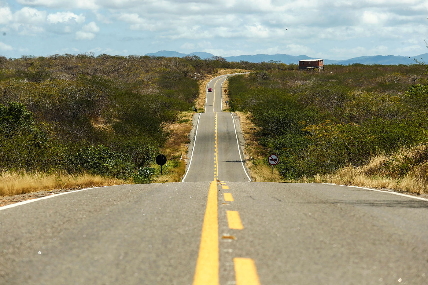
WJQUINZE206- CE - 18/08/2015 - SECA 100 ANOS/QUINZE - ESPECIAL PARA CIDADES OE - Cem anos depois da grande seca que assolou o sertão central do Ceará e inspirou o livro O Quinze, de Rachel de Queiroz, a região enfrenta outro grave período de falta de chuva pelo terceiro ano seguido. A reportagem refaz o trajeto da família fictícia criada pela escritora, formada por Chico Bento, Cordulna e cinco filhos, entre Quixadá e Fortaleza. Muita famílias ainda sofrem com a falta de água e não conseguiram produzir milhoe e feijão, os produtos da região. Na foto, CE 060 que liga Quixada a Fortaleza Foto: WILTON JUNIOR/ESTADÃO

Caminhada. A rodovia CE-060 liga Quixadá a Fortaleza, trecho que, na ficção, foi feito a pé, em caminho de terra, por Chico Bento

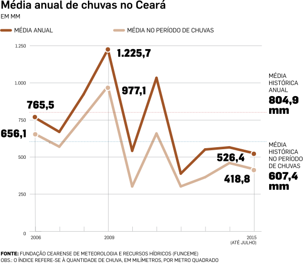
Passados cem anos da grande seca de 1915, retratada por Rachel de Queiroz no romance “O Quinze”, lançado em 1930, o sertão central do Ceará ainda sofre com a falta de chuva. A região está no quarto ano de estiagem intensa. Os açudes e barragens estão em níveis baixos, as cisternas instaladas nas casas das famílias de baixa renda, que ajudam a aliviar a falta de água, já não são suficientes para o abastecimento.

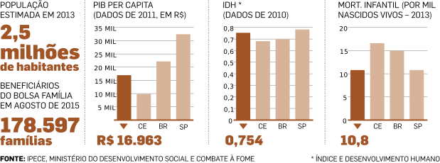
No livro, o vaqueiro Chico Bento parte com a família, a pé, para Fortaleza, depois de ser dispensado pela dona da fazenda onde trabalhava. O Estado percorreu o caminho descrito por Rachel de Queiroz. Embora sofram com a seca, as cidades têm benefícios pelo fato de estarem próximas da capital. A rodovia estadual está em bom estado, há empreendimentos imobiliários em andamento. Na zona rural, no entanto, as famílias lamentam a baixa produção de milho e feijão que, este ano, serviu no máximo para consumo próprio. Entre os muito pobres, o Bolsa Família é a única renda fixa mensal.


ONDE FICA


O caminho da família  de Chico Bento em ‘O Quinze’, revisitado pela reportagem

QUIXADÁ, A RETIRADA

Na ficção, o protagonista Chico Bento, vaqueiro dispensado pela patroa que não tinha como manter os empregados, diante do estrago causado pela seca, parte de Quixadá para Fortaleza, a pé. O ponto de partida é a localidade hoje chamada Daniel de Queiroz, a cerca de 160 quilômetros de Fortaleza, onde até hoje está a fazenda da família de Rachel de Queiroz, chamada “Não me deixes”. No livro, Chico Bento trabalhava na fazenda Aroeiras, nome fictício. Ele parte com a mulher, a cunhada e cinco filhos.

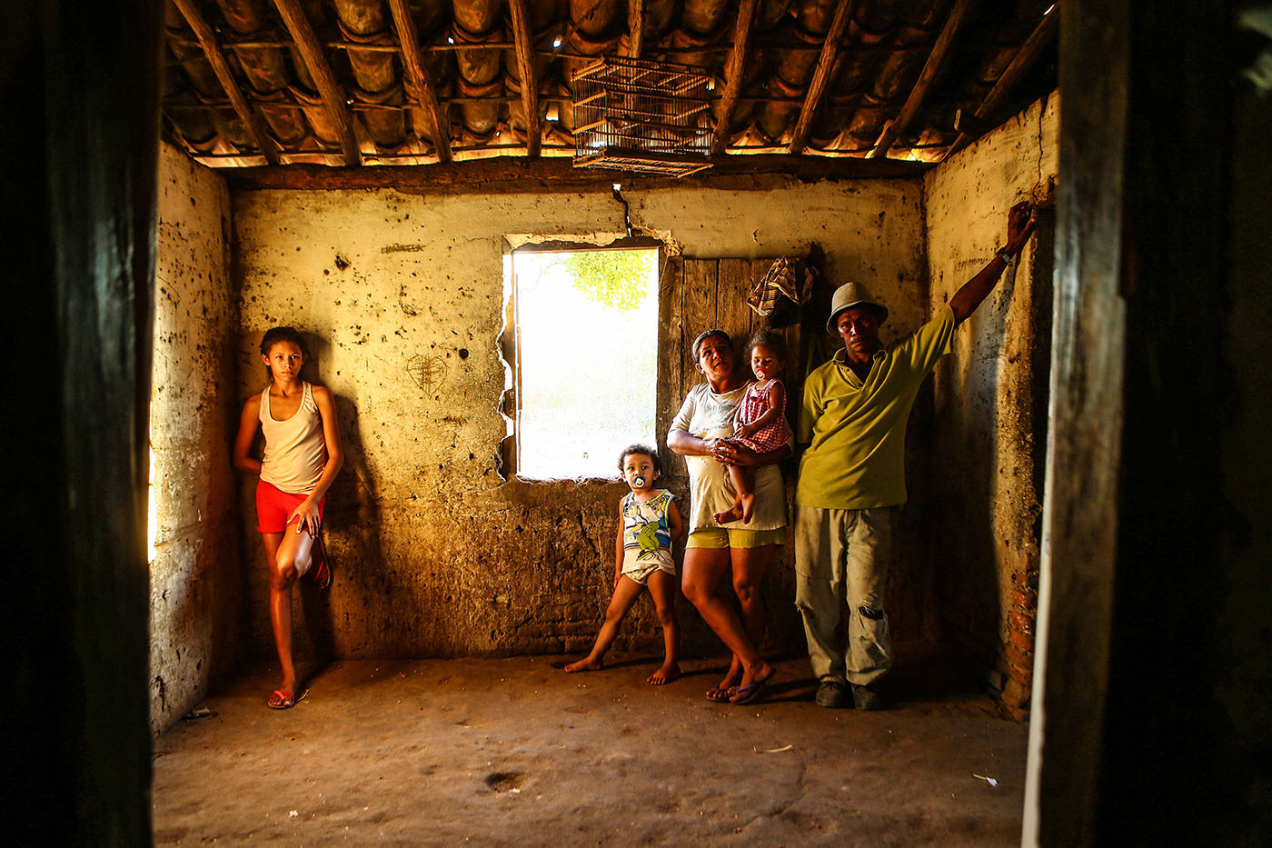
WJQUIXADA1 - CE - 18/08/2015 - SECA 100 ANOS/QUINZE - ESPECIAL PARA CIDADES OE - Cem anos depois da grande seca que assolou o sertão central do Ceará e inspirou o livro O Quinze, de Rachel de Queiroz, a região enfrenta outro grave período de falta de chuva pelo terceiro ano seguido. A reportagem refaz o trajeto da família fictícia criada pela escritora, formada por Chico Bento, Cordulna e cinco filhos, entre Quixadá e Fortaleza. Muita famílias ainda sofrem com a falta de água e não conseguiram produzir milhoe e feijão, os produtos da região. Na foto, Paulo Sérgio Alexandre Ferreira com a mulher, Zélia e os filhos Bianca, de 16 anos, Francisco Vitor, de 3, e Francisca Vitória, de 2. Cisterna instalada pelo governo do Estado está quase seca e família tem que pegar água em cacimba próxima ao barraco onde vive, na periferia de Quixadá. Foto: WILTON JUNIOR/ESTADÃO

 Lavoura. Paulo Sérgio, a mulher e os filhos sofrem com a seca na periferia de Quixadá: “não cheguei a fazer um saco de feijão”

A VIDA EM QUIXADÁ

DESALENTO E ESPERANÇA EM QUIXADÁ 

Morador  do distrito de Juatama, em Quixadá, Paulo Sérgio Alexandre Ferreira, de 44 anos, passa dificuldades com a cisterna quase vazia. Ele vive com a mulher, Zélia, de 37 anos, e cinco filhos em uma casa precária, de barro, sem água encanada e raros móveis. Quase todo dia, alguém busca água na cacimba mais próxima. “Não cheguei a fazer um saco de feijão”, lamenta Paulo Sérgio, que tem um roçado atrás da casa. Apesar das dificuldades, o Chico Bento de 2015 não pensa em sair em busca de outras oportunidades. A família recebe R$ 190 mensais do programa Bolsa Família, a única renda garantida. “Não gosto de cidade. A gente só vai lá por precisão”, afirma.

No mesmo município de Quixadá, outra história é de esperança. A seca que devasta as plantações e obriga famílias a buscarem água em cacimbas e poços distantes de casa também cria oportunidades para um grupo de jovens do distrito de Juatama. Por causa da falta de chuva e dos ventos fortes, Quixadá tornou-se um dos melhores locais do mundo para o voo livre. No inverno, atletas de vários países chegam à cidade, na expectativa de baterem o recorde de voo em linha reta batido na própria cidade. Os pilotos passaram a chamar jovens da região para ajudarem na montagem de equipamentos, dirigirem as caminhonetes e colaborarem no controle dos voos. Aos poucos, eles aprenderam a voar e hoje são também instrutores.

A Associação de Voo Livre do Sertão Central já reúne 24 jovens, que estimulam as crianças a também se interessarem por decolagens e pousos. “Em 1998, 12 meninos foram contratados para ajudar os que chegavam a Quixadá para voar e começaram a sonhar em voar também. Eu era um desses meninos. Graças a Deus, no meio das dificuldades da seca, uma janela se abre e surge uma oportunidade”, diz Diego Oliveira Dantas, de 26 anos, um dos rapazes que trabalham com voo livre em Quixadá. Na semana em que o Estado esteve em Quixadá, um dos grandes nomes do voo livre do País, Luiz Henrique Tapajós Antunes dos Santos, o Sabiá, estava na cidade, onde gravou parte do documentário que estrela para um canal fechado de TV. Sabiá e seus companheiros usaram os serviços de Diego e outros monitores locais.

QUIXADÁ EM NÚMEROS

ITAPIÚNA, A FOME

Município que em 1915 era um povoado chamado Castro, parte da cidade de Baturité. No livro, foi no Castro que bateu pela primeira vez a fome na família.

Chico Bento consegue trocar uma rede por farinha e rapadura.

Também no Castro, Mocinha, irmã de Cordulina, mulher de Chico Bento, decide abandonar o grupo.

A VIDA EM ITAPIÚNA

Na casa de Vera Lúcia de Almeida Ferreira, de 39 anos, não há água encanada. A cisterna instalada pelo governo do Estado está praticamente vazia. Ela busca água no rio próximo para lavar roupa e cozinhar. Recebe R$ 194 mensais do Bolsa Família para sustentar o casal e dois filhos. A cada dois meses, gasta R$ 50 com um botijão de gás. A conta de luz está em torno de R$ 26 mensais. “Antes eu pagava entre R$ 12 e R$ 15 de luz. Agora que inventaram essa bandeira vermelha, está o dobro. Daqui a pouco, o dinheiro vai todo para gás e energia”, preocupa-se Vera Lúcia. No dia 20 de agosto, uma quinta-feira, Vera Lúcia teve que gastar R$ 6 para mandar a filha Verilane, de 12 anos, para a escola. O ônibus escolar quebrou e a solução foi pagar uma van para levar e um mototáxi para trazer a menina para casa. No dia 21, Verilane não foi à escola. “Agora vou ter que esperar o ônibus consertar, não dá para gastar esse dinheiro todo dia”, afirmou Vera Lúcia.

Perto dali vive Antônio Osvaldo Gomes de Souza, de 40 anos. O filho Erison, de 9, só não perdeu as aulas porque Antônio levou e pegou de bicicleta. O menino depende do mesmo ônibus escolar com defeito. A Bolsa Família que sustenta Antonio, a mulher, Adriana, e o filho é de R$ 164 mensais.

ITAPIÚNA EM NÚMEROS

WJQUINZE200 - CE - 18/08/2015 - SECA 100 ANOS/QUINZE - ESPECIAL PARA CIDADES OE - Cem anos depois da grande seca que assolou o sertão central do Ceará e inspirou o livro O Quinze, de Rachel de Queiroz, a região enfrenta outro grave período de falta de chuva pelo terceiro ano seguido. A reportagem refaz o trajeto da família fictícia criada pela escritora, formada por Chico Bento, Cordulna e cinco filhos, entre Quixadá e Fortaleza. Muita famílias ainda sofrem com a falta de água e não conseguiram produzir milhoe e feijão, os produtos da região. Na foto, Vera Lúcia de Almeida Ferreira, de 39 anos, mora na beira da estrada em Itapiuna. Tem uma cisterna praticamente vazia. Conta que o governo do Estado instalou uma caixa d'água e promete levar água encanada, mas ainda não chegou. Foto: WILTON JUNIOR/ESTADÃO

Espera. Sem água encanada, Vera Lúcia aguarda a chegada de caminhão pipa para abastecer a cisterna quase vazia

BATURITÉ, A MORTE

Em algum ponto não definido deste município, Josias, um dos filhos de Chico Bento e Cordulina, morre intoxicado, depois de comer um pedaço de manipeba, um tipo venenoso de mandioca.

Foi também em Baturité que o vaqueiro decidiu vender a mula que acompanhava a família na travessia, Limpa-Trilho.

Já no fim do livro, Baturité volta em outra cena trágica. Dona Inácia, moradora que Quixadá que passara uma temporada em Fortaleza com a neta, Conceição, está no trem de volta para casa. Na estação de Baturité, se surpreende com uma moça que chama por ela. Era Mocinha, a cunhada de Chico Bento que decidira tentar a vida no Castro. Não deu certo.

A VIDA EM  BATURITÉ

Auxiliar de serviços gerais da rede pública de educação, Maria de Carvalho Félix, de 69 anos,  vive com três filhas e seis netos em uma casa confortável próxima à antiga estação de trem de Baturité, hoje transformada em museu. Conseguiu comprar uma antiga casa da Rede Ferroviária, tem água encanada e planeja, um dia, construir um andar de cima para abrigar melhor a família. “O trem era o transporte dos pobres, eu viajava para Juazeiro quase toda semana, para visitar minha mãe. Isso aqui (a antiga estação) vivia cheio, de passageiros e de gente vendendo frutas, macaxeira. Era muito bonito”, diz Maria, ao lado da filha Alexandra, de 38 aos, também auxiliar de serviços gerais da rede escolar e da neta Ana Clara, de oito anos. “Este ano a seca está grande, mas ainda temos água, se Deus quiser não vai faltar. Na seca de 1984, a torneira secou. Quando chegavam os caminhões pipa, era uma correria para garantir água”, lembra Maria.

BATURITÉ EM NÚMEROS


WJQUINZE61 - CE - 21/08/2015 - SECA 100 ANOS/QUINZE - ESPECIAL PARA CIDADES OE - Cem anos depois da grande seca que assolou o sertão central do Ceará e inspirou o livro O Quinze, de Rachel de Queiroz, a região enfrenta outro grave período de falta de chuva pelo terceiro ano seguido. A reportagem refaz o trajeto da família fictícia criada pela escritora, formada por Chico Bento, Cordulina e cinco filhos, entre Quixadá e Fortaleza. Muita famílias ainda sofrem com a falta de água e não conseguiram produzir milhoe e feijão, os produtos da região. Na foto, Maria de Carvalho Félix, de 69 anos, a filha Alexandra Carvalho Félix, de 38, e a neta Ana Clara, de 8, vivem em frente à antiga estação de trem de Baturité, hoje transformada em museu. Foto: WILTON JUNIOR/ESTADÃO

Passado. Maria vive com três filhas e seis netos em frente à estação desativada: saudade dos tempos da linha férrea

ACARAPE, O TREM

Já perto de Fortaleza, a uma distância de cerca de 50 quilômetros, a família vive novo drama. Chico Bento e Cordulina  descobrem que Pedro, o filho mais velho, tinha desaparecido.

É em Acarape que o que restou da família – Chico Bento, Cordulina e três filhos – finalmente consegue embarcar no trem para Fortaleza. O delegado de Acarape, Luís Bezerra, compadre de Chico Bento, padrinho de Josias, já morto, não consegue encontrar Pedro, mas paga as passagens para os retirantes concluírem a viagem.

A VIDA EM ACARAPE

Auxiliadora Silva Oliveira Rodrigues, de 36 anos, e Francisca Iraneide Pereira  de Lima, de 42, são vizinhas na periferia de Acarape, na beira da estrada que leva a Fortaleza. Em frente às casas pobres onde vivem, vendem frutas e verduras que compram na feira. Os clientes são, na maioria, motoristas que passam pela rodovia estadual. Há três anos,  chegou água encanada na localidade onde moram. A vida mudou para melhor, embora a pobreza não tenha aliviado. “Se Deus usar de misericórdia, não vai faltar água”, diz Auxliadora. A última chuva, lembra o marido dela, Édio Ferreira, presbítero da Assembleia de Deus, foi no dia 17 de julho.

WJQUINZE208 - CE - 21/08/2015 - SECA 100 ANOS/QUINZE - ESPECIAL PARA CIDADES OE - Cem anos depois da grande seca que assolou o sertão central do Ceará e inspirou o livro O Quinze, de Rachel de Queiroz, a região enfrenta outro grave período de falta de chuva pelo terceiro ano seguido. A reportagem refaz o trajeto da família fictícia criada pela escritora, formada por Chico Bento, Cordulina e cinco filhos, entre Quixadá e Fortaleza. Muita famílias ainda sofrem com a falta de água e não conseguiram produzir milhoe e feijão, os produtos da região. Na foto, Em Acarape na CE 060 que liga Quixada a Fortaleza, Francisco Lopes da Silva, de 70 anos, leva ração em uma carroça. Este ano, conseguiu tirar apenas um saco (60 quilos) de feijão de seu pequeno roçado. Foto: WILTON JUNIOR/ESTADÃO

Memória.  À beira da CE-060 Francisco, de 70 anos, lembra as muitas secas da região: “a pior foi a de 1970”

Francisca vive com o marido, Francisco Vitorino da Silva, e seis filhos, de 5 a 24 anos. Recebe “trezentos reais e uns quebradinhos” de Bolsa Família, a única renda fixa. “Tem dia ruim, que a gente não vende mais que R$ 10. Outros são melhores, dá para vender, R$ 30, R$ 40. Antigamente, a gente tinha que buscar água na cacimba, levava na cabeça”, lembra Francisca.

Na mesma estrada onde vivem Auxiliadora e Francisca, o lavrador Francisco Lopes da Silva segue em direção ao distrito de Antônio Diogo, no município de Redenção, onde mora. Nunca teve abastecimento direto em casa e, mesmo em tempos de chuva, tem de buscar água no poço. Aos 70 anos, tem a memória de muitas secas no sertão central do Ceará. “Do que me lembro, a pior foi a de 1970, mas sofremos muito também na de 1958”, diz.

ACARAPE EM NÚMEROS

FORTALEZA, O CAMPO
DE CONCENTRAÇÃO

Na etapa final do livro, Chico Bento e a família desembarcaram em Fortaleza, na Estação do Matadouro, que depois passou a se chamar estação Otávio Bonfim e hoje, é uma ruína cheia de lixo em volta.

Da estação, o casal e os filhos foram direto para o campo de concentração do Alagadiço. Muito antes da Segunda Guerra, no Ceará já se usava o termo campo de concentração, que designava o local que concentrava os flagelados, distribuía comida. Os retirantes se ajeitavam pelos cantos e saíam em busca de trabalho ou partiam para o Norte, para trabalhar no cultivo da borracha, ou para o Sudeste. Os campo de concentração foi criado para evitar que os retirantes se espalhassem pela capital e chegassem às áreas nobres, em busca de esmolas e trabalho.

O Alagadiço é hoje a parte mais pobre do bairro Otávio Bonfim, também chamado Farias Brito. É uma área carente e violenta.

A personagem Conceição, professora nascida em Quixadá que vivia em Fortaleza, é voluntária do Campo de Concentração e madrinha de Duquinha, um dos filhos de Chico Bento e Cordulina. Conceição convence Cordulina a deixar Duquinha com a madrinha e passa a criá-lo.

Chico Bento, Cordulina e os dois filhos que restaram partiram no porto de Fortaleza para São Paulo.

A VIDA EM FORTALEZA

CORRECAO DE LEGENDAFORTALEZA1 - CE - 18/08/2015 - SECA 100 ANOS/QUINZE - ESPECIAL PARA CIDADES OE - Cem anos depois da grande seca que assolou o sert„o central do Cear· e inspirou o livro O Quinze, de Rachel de Queiroz, a regi„o enfrenta outro grave perÌodo de falta de chuva pelo terceiro ano seguido. A reportagem refaz o trajeto da famÌlia fictÌcia criada pela escritora, formada por Chico Bento, Cordulna e cinco filhos, entre Quixad· e Fortaleza. Muita famÌlias ainda sofrem com a falta de ·gua e n„o conseguiram produzir milhoe e feij„o, os produtos da regi„o. Na foto, O comerciante Francisco Lopes da Silva, de 70 anos, ex-funcion·rio da Rede Ferrovi·ria, que Mora e tem um pequeno bar em frente ‡ antiga estaÁ„o do Matadouro, onde, no livro, Chico Bento e a famÌlia desembarcaram do trem quando chegaram em Fortaleza. Foto: WILTON JUNIOR/ESTAD√O

Alagadiço. Da janela de seu bar, Ramiro vê a estação e o terreno onde funcionou o campo de concentração

Funcionário da Rede Ferroviária entre 1976 e 1998, Ramiro Casimiro Barreto, de 67 anos, agora aposentado, mora e trabalha no pequeno bar aberto por ele em frente à estação desativada de Otávio Bonfim, que em 1915 se chamava Estação do Matadouro, por causa da proximidade de um abatedouro de animais. Ramiro ouviu falar da grande seca daquele ano, mas não conhece “O Quinze” nem a triste história do campo de concentração. Da janela de seu bar, avista o abandono da antiga estação e a comunidade que hoje ocupa o Alagadiço. Apesar da violência que domina a região onde há cem anos funcionava o acampamento dos flagelados, Ramiro diz que “é um bom lugar para morar”. Mas lamenta o fim da ferrovia. “Cansei de pegar o trem para Baturité. Depois essa linha acabou e ficou o trecho Fortaleza-Maracanaú, até 2011. Mas aí acabaram com o trem do interior e entraram os empresários de ônibus. Depois fizeram o metrô e isso aí é o que restou da ferrovia”, diz Ramiro.

FORTALEZA EM NÚMEROS


 Capítulo 2: A LEMBRANÇA DE RACHEL DE QUEIROZ


Capítulo 3: A SECA DE 1932: MEMÓRIA DE UM CAMPO DE CONCENTRAÇÃO


 Capítulo 4

A seca de 2015 no sertão central do Ceará

LAVAR ROUPA NOS RIOS E BUSCAR ÁGUA EM POÇOS FAZ PARTE DA ROTINA DOS MORADORES DAS CIDADES QUE SOFREM
COM A FALTA DE CHUVA. LAVOURAS FORAM PREJUDICADAS

CENAS DA SECA NO SERTÃO CENTRAL. Clique e assista ao video

No caminho até Senador Pompeu, pela BR 116, a reportagem do Estado encontrou famílias que têm como rotina buscar água nas cacimbas (poços), açudes e rios. Em um caminho estreito na beira da estrada, Alzira da Silva Gomes, de 52 anos, seguia em uma carroça com a  família para um banho no açude próximo, mais os jumentos Juca e Jubileu, no distrito de Triângulo, em Chorozinho. Alzira tem ainda a vaca Melindrosa e o cavalo Melindroso. A renda é garantida com o Bolsa Família de R$ 252 mensais. Neto de Alzira, Davi, de 14 anos, foi o único jovem encontrado pela reportagem que conhecia – e leu – o livro “O Quinze”, de Rachel de Queiroz, sobre a família que fugiu da seca em Quixadá e partiu para Fortaleza. “Li duas vezes. Muito triste, uma criança morre no caminho, a outra desaparece”, recorda Davi.

Estiagem. A seca modificou a paisagem de cidades como Senador Pompeu, Quixeramobim e Chorozinho

No mesmo caminho da família de Alzira, estavam as vizinhas Conceição Rufino Pinheiro, de 48 anos, e Daiane de Souza Coutinho, de 17, ambas donas de casa. Cada uma empurrava um carrinho de mão, com galões que seriam enchidos no poço. Reuniram 130 litros, que seriam transportados em duas viagens. “Tem que pegar água todo dia, mas agora os poços estão esvaziando”, diz Conceição.

Em Senador Pompeu, o rio Patu está quase vazio e os moradores comemoravam, no dia 18 de agosto, que as comportas da barragem foram abertas, liberando um pouco de água. “Ontem estava muito pior, que surpresa boa”, comemorou Fernanda Maria Simão, de 64 anos, que lavava roupa no rio com a vizinha Maria de Souza, de 52. Fernanda tem água encanada em casa, mas economiza lavando roupa no rio. “A vida no sertão é boa, mas é de muito sofrimento. Graças a Deus tenho saúde, não paro de trabalhar. Esse rio aqui quando enche é a coisa mais linda. Gosto de ficar aqui, vendo a natureza”, diz Fernanda, viúva, que recebe dois salários mínimos da própria pensão e a do marido. Tem uma vida confortável, diz, e complementa a renda cobrando R$ 20 pela trouxa pequena lavada e R$ 30 pela grande.

Rotina. Sem água encanada, poço ou cisterna, João Batista vai mais de uma vez por dia pegar água no rio Patu

A vida de João Batista dos Santos, de 50 anos, é mais difícil. Sua casa não tem água encanada e ele vai ao rio Patu buscar água mais de uma vez por dia. Cria galinhas e porcos, planta milho e feijão. “O milho não segurou este ano. Feijão foi muito pouco”, lamenta.

OS NÚMEROS DA SECA

Desde 2012 o nível de chuvas no Estado é muito baixo, com médias inferiores à metade das registradas em 2009, melhor ano da década

How Climate Change is Behind the Surge of Migrants to Europe (Time) + other related articles

Even as Europe wrestles over how to absorb the migrant tide, experts warn that the flood is likely to get worse as climate change becomes a driving factor.

More than 10,000 migrants and refugees traveled to Western Europe via Hungary over the weekend, fleeing conflict-ravaged and impoverished homelands in the hope of finding a more secure life abroad. Even as Europe wrestles over how to absorb the new arrivals, human rights activists and migration experts warn that the movement is not likely to slow anytime soon. Intractable wars, terror and poverty in the Middle East and beyond will continue to drive the surge. One additional factor, say scientists, is likely to make it even worse: climate change.

From 2006 to 2011, large swaths of Syria suffered an extreme drought that, according to climatologists, was exacerbated by climate change. The drought lead to increased poverty and relocation to urban areas, according to a recent report by the Proceedings of the National Academy of Sciences and cited by Scientific American. “That drought, in addition to its mismanagement by the Assad regime, contributed to the displacement of two million in Syria,” says Francesco Femia, of the Washington, D.C.-based Center for Climate and Security. “That internal displacement may have contributed to the social unrest that precipitated the civil war. Which generated the refugee flows into Europe.” And what happened in Syria, he says, is likely to play out elsewhere going forward.

Across the Middle East and Africa climate change, according to climatologists at the U.S. Department of Defense-funded Strauss Center project on Climate Change and African Political Stability in Texas, has already affected weather. These changes have contributed to more frequent natural disasters like flooding and drought. Agricultural land is turning to desert and heat waves are killing of crops and grazing animals. Over the long term, changing weather patterns are likely to drive farmers, fishermen and herders away from affected areas, according to Femia’s Center for Climate and Security, and into urban centers — as has already happened in Syria. Both the Pentagon, which calls climate change a “threat multiplier” and U.S. Presidential candidate Hillary Clinton have warned of “water wars,” in which rival governments or militias fight over declining resources, sending even greater waves of migrants in search of security and sustenance. On Aug. 31, Secretary of State John Kerry warned that climate change could create a new class of migrants, what he called “climate refugees” at a conference on climate change conference in Anchorage, Alaska. “You think migration is a challenge to Europe today because of extremism, wait until you see what happens when there’s an absence of water, an absence of food, or one tribe fighting against another for mere survival,” he said.

Security analysts say they are already seeing the impact, particularly in migration patterns from northern Africa and the Sahel region, which is the band of farmland just below the Sahara desert. “All the indicators seem to fairly solidly convey that climate change — desertification and lack of water, or floods, are massively contributing to human mobility,” says Michael Werz, a Senior Fellow at the Center for American Progress policy group in Washington, D.C. Syrians and Afghans may make up the largest number of refugees flooding into Europe right now, but Africans from the Sahel are not far behind. “No one is saying ‘I’d better pack my stuff and go to Europe because I expect CO2 emissions to rise,’” he says. But the knock on effects — failed crops, ailing livestock and localized conflicts over resources—are already driving residents of the Sahel northward to flee poverty. Libya’s collapse has opened the doors wide for migrants, and the smugglers who ship them across the Mediterranean to Europe.

As Europeans debate over what to do about the influx of migrants, there has been a call for an international effort to stabilize the regions from which they come. But it’s not enough to talk about ending conflict, says Femia. “A lot more attention has to be paid to putting more resources into climate adaptation and water security and food security, so migration doesn’t become the primary option.” Tackling the problem at its source doesn’t mean ending conflict, but stopping it before it starts. And that means addressing climate change as well.

The European Migrant Crisis Is A Nightmare. Climate Change Will Make It Worse (Huff Post)

Hundreds of thousands of migrants are seeking refuge in Europe, but millions more will be displaced as the climate warms.

<span class='image-component__caption' itemprop="caption">2-year-old Aliou Seyni Diallo eats dry couscous given to him by a neighbor, after he collapsed in tears of hunger in the village of Goudoude Diobe, in the Matam region of northeastern Senegal, Tuesday, May 1, 2012.</span>

CREDIT: REBECCA BLACKWELL/ASSOCIATED PRESS. 2-year-old Aliou Seyni Diallo eats dry couscous given to him by a neighbor, after he collapsed in tears of hunger in the village of Goudoude Diobe, in the Matam region of northeastern Senegal, Tuesday, May 1, 2012.

The hundreds of thousands of migrants arriving in Europe or dying on the way to its shores could be a harbinger of things to come, researchers and policymakers warn, because a potentially greater driver of displacement looms on the horizon: climate change.

As U.S. Secretary of State John Kerry warned at a recent State Department-led conference on climate change in the Arctic, the scenes of chaos and heartbreak in Europe will be repeated globally unless the world acts to mitigate climate change.

“Wait until you see what happens when there’s an absence of water, an absence of food, or one tribe fighting against another for mere survival,” Kerry said.

World leaders have long warned that natural disasters and degraded environments linked to climate change could — indeed, have already started to — drive people from their homes. UN High Commissioner for Refugees António Guterres declared in 2009 that climate change will create millions of refugees and internally displaced populations. “Not only states, but cultures and identities will be drowned,” Guterres said.

Displacement is already happening in some parts of the world. Almost 28 million people on average were displaced by environmental disasters every year between 2008 and 2013, according to the Internal Displacement Monitoring Center — roughly three times as many as were forced from their homes by conflict and violence.

It’s difficult to predict exactly how many more may be displaced as climate change progresses. “When global warming takes hold there could be as many as 200 million people overtaken” by the consequences, professor Norman Myers of Oxford University argued in a 2005 paper. For comparison’s sake, 350,000 migrants sought entry into the  European Union in 2014, the International Organization for Migration estimated.

Few countries or international organizations are prepared to deal with environmentally displaced people. As a 2011 report from the European Parliament’s Directorate-General for Internal Policies detailed, there is no specific legal protection for “environmentally displaced individuals” beyond temporary measures that would prove insufficient if the environmental damage to their homeland endured.

The UN has a non-binding agreement on internal displacement from 1998 that includes provisions for people fleeing natural disasters, but it is not obligatory and includes no penalties for countries that ignore it, as Roger Zetter, a professor emeritus in refugee studies at Oxford, told The Huffington Post. The portions addressing natural disasters focus on storms, not the more complex and slow-onset effects of climate change.

Myers’ sensational prediction of hundreds of millions of climate change refugees has come under fire in the years since its 2005 publication. “It’s a very contentious overestimate,” Zetter said. “It’s a back-of-the-envelope figure.”

It’s difficult, if not impossible, to get data on the number of current migrants who left their homes primarily because of climate change. For most, environmental degradation is one factor among many, Zetter and other experts cautioned. Nevertheless, climate change-related environmental impacts will present “very significant challenges,” Zetter said.

“What climate change and displacement do is present developmental problems for countries that are already struggling,” he explained. “If you’ve got to start spending more and more money on flood relief channels or earthquake-proof buildings or increasing huge water transfer programs to cope with depleting aquifers, there’s no question that it will add a huge additional financial burden and make planning and development strategies more difficult.” 

And for some countries, climate change poses an immediate and very real threat — countries like the small island states threatened by rising seas. “If there’s no land, they’ll have to leave,” Zetter said.

<span class='image-component__caption' itemprop="caption">In this March 30, 2004 file photo, a man fishes on a bridge on Tarawa atoll, Kiribati. Fearing that climate change could wipe out their entire Pacific archipelago, the leaders of Kiribati are considering an unusual backup plan: moving the populace to Fiji.</span>

CREDIT: RICHARD VOGEL/ASSOCIATED PRESS. In this March 30, 2004 file photo, a man fishes on a bridge on Tarawa atoll, Kiribati. Fearing that climate change could wipe out their entire Pacific archipelago, the leaders of Kiribati are considering an unusual backup plan: moving the populace to Fiji.

That includes places like Kiribati, a country made up of 33 islands in the remote South Pacific. Kiribati will be among the first countries to vanish beneath the rising ocean, possibly as soon as the end of this century. But long before then, its atolls and reef islands will be uninhabitable for their 103,000 residents if a violent storm comes crashing through, or if the ocean seeps into their already inadequate supply of fresh groundwater. Half of the country’s citizens live on the Tarawa Atoll, a crescent of white sand two-thirds of a mile across whose highest point is just 10 feet above the ocean.

Operating on the unfortunate assumption that the sea will swallow the country, the government of Kiribati purchased 6,000 acres of land in Fiji last year, in case they need to uproot an entire people and put them somewhere else.

Major storms and flooding already cause tremendous displacement — almost 28 million per year on average, according to the Internal Displacement Monitoring Center. Many more are affected, but not necessarily displaced — an average of 140 million people yearly, the International Panel on Climate Change reports. Scientists expect climate change to make violent storms like Typhoon Haiyan, which forced a million people to flee their homes in the Philippines in 2013, stronger and more frequent.

Typhoons and monsoon floods hit people hard and fast, forcing them to literally flee for their lives. Scientists call those rapid-onset climate events. But there are also slow-onset climate events like drought, desertification and sea level rise.

These slow-moving changes are “much more difficult to relate to mobility patterns,” Albert Kraler, a program manager for research at the International Center for Migration Policy Development in Vienna, told HuffPost. Often, environmental changes are just “one of the factors informing people’s migration choices.”

Despite the difficulty in determining exact numbers, the United Nations Environment Program concluded in a 2011 study on the Sahel, a semi-arid belt across northern Africa, that “migration occurs when livelihoods cannot be maintained, especially when agriculture or herding is severely affected by environmental degradation or extreme events.”

The changes in the Sahel are perhaps the most obvious example of slow-onset events. The UN dubbed the region “ground zero” for climate change “due to its extreme climatic conditions and highly vulnerable population.” Its arid climate and infrequent rain are getting worse, and scientists blame climate change. The rain is less predictable than it used to be — sometimes there is too much and sometimes nowhere near enough. For almost everyone in the Sahel, food has become more expensive and scarcer. As a result, 30 percent of households in Burkina Faso, in the heart of the Sahel, have relocated in the last 20 years because they could no longer survive, The Guardian reported in 2013.

People have always migrated across this region. But these days, “the traditional temporary and seasonal migration patterns of many farmers, herders and fishermen in the region are increasingly being replaced by a more permanent shift southward and to urban areas,” UNEP reports. “Nearly half of the West African population now lives in largely overcrowded coastal cities, including 12 townships of over one million inhabitants along the coastline from Senegal to Nigeria.”

The population of the Sahel region is expected to skyrocket over the next few decades. Competition between tribes and ethnic groups, pastoralists, farmers and fishermen over ever-scarcer natural resources, which has existed for as long as people have lived there, is becoming intense. And then there’s Boko Haram. Its fighters have set up camps on islands emerging out of Lake Chad, a once-majestic expanse of fresh water that in the past supported millions of people in the heart of the Sahel. But the lake has lost 90 percent of its area since the 1960s. Now, there’s a militant Muslim fundamentalist insurgency taking hold amid an ongoing environmental disaster.

<span class='image-component__caption' itemprop="caption"><!-- [if gte mso 9]>

<![endif]--> <!-- [if gte mso 9]>

  Normal
  0

  false
  false
  false

  EN-US
  JA
  X-NONE

<![endif]--><!-- [if gte mso 9]>

<![endif]--> <!-- [if gte mso 10]>

 /* Style Definitions */
table.MsoNormalTable
	{mso-style-name:"Table Normal";
	mso-tstyle-rowband-size:0;
	mso-tstyle-colband-size:0;
	mso-style-noshow:yes;
	mso-style-priority:99;
	mso-style-parent:"";
	mso-padding-alt:0in 5.4pt 0in 5.4pt;
	mso-para-margin:0in;
	mso-para-margin-bottom:.0001pt;
	mso-pagination:widow-orphan;
	font-size:12.0pt;
	font-family:Cambria;
	mso-ascii-font-family:Cambria;
	mso-ascii-theme-font:minor-latin;
	mso-hansi-font-family:Cambria;
	mso-hansi-theme-font:minor-latin;}

<![endif]--> <!--StartFragment--> <!--EndFragment-->
A dead donkey lies partially covered by the wind-swept sand near the village of Dala in the Sahel belt of Chad, Friday, April 20, 2012. UNICEF estimates that 127,000 children under five in Chad's Sahel belt will require lifesaving treatment for severe acute malnutrition this year, with an estimated 1 million expected throughout the wider Sahel region. The organization says the current food and nutrition crisis stems from scarce rainfalls in 2011, which caused poor harvests and livestock production.</span>

CREDIT: BEN CURTIS/ASSOCIATED PRESS. A dead donkey lies partially covered by the wind-swept sand near the village of Dala in the Sahel belt of Chad, Friday, April 20, 2012. UNICEF estimates that 127,000 children under five in Chad’s Sahel belt will require lifesaving treatment for severe acute malnutrition this year, with an estimated 1 million expected throughout the wider Sahel region. The organization says the current food and nutrition crisis stems from scarce rainfalls in 2011, which caused poor harvests and livestock production.

Climate change is also a factor in the worsening storms and environmental degradation of coastal South Asia — factors that, when combined with mismanagement and political dysfunction, are putting millions of people at risk. Some have already started to migrate because their ways of living are becoming impossible. In the Indus delta in Pakistan, entire villages have been wiped off the map. Bangladeshis and Indians in the Sundarbans, a vast mangrove forest where the Ganges meets the sea, are heading inland, away from the rising ocean and the increasingly saline farmland.

Bangladesh is expected to be the largest single source of climate refugees, with up to 30 million people at risk. Many end up in slums in cities like Dhaka, Bangladesh’s capital and the world’s fastest-growing megacity. Some 70 percent of Dhaka’s slum dwellers moved there because of environmental degradation, according to the International Organization for Migration.

Migrants and refugees across the world, driven by rapid-onset natural disasters or by a complex combination of the more slow-moving effects of a changing climate, are already putting immense strain on the countries and cities they end up in. A lot of the time locals aren’t happy to see them, and many governments have been caught unprepared and unwilling to take them in.

Already, migrants and refugees across the world are already putting immense strain on the countries and cities where they end up.

In Europe, Hungary is putting up a fence to keep migrants and refugees out. “We don’t want to [live together with Muslims],” Hungary’s prime minister Victor Orban said on Thursday, “and I think we have a right to decide that we do not want a large number of Muslim people in our country.”

<span class='image-component__caption' itemprop="caption"><!-- [if gte mso 9]>

<![endif]--> <!-- [if gte mso 9]>

  Normal
  0

  false
  false
  false

  EN-US
  JA
  X-NONE

<![endif]--><!-- [if gte mso 9]>

<![endif]--> <!-- [if gte mso 10]>

 /* Style Definitions */
table.MsoNormalTable
	{mso-style-name:"Table Normal";
	mso-tstyle-rowband-size:0;
	mso-tstyle-colband-size:0;
	mso-style-noshow:yes;
	mso-style-priority:99;
	mso-style-parent:"";
	mso-padding-alt:0in 5.4pt 0in 5.4pt;
	mso-para-margin:0in;
	mso-para-margin-bottom:.0001pt;
	mso-pagination:widow-orphan;
	font-size:12.0pt;
	font-family:Cambria;
	mso-ascii-font-family:Cambria;
	mso-ascii-theme-font:minor-latin;
	mso-hansi-font-family:Cambria;
	mso-hansi-theme-font:minor-latin;}

<![endif]--> <!--StartFragment--> <!--EndFragment-->
Detainees sit in a detention center on the outskirts of Kuala Lumpur, Malaysia, July 23, 2009. Australia came under fire from the U.N. children's aid agency and human rights advocates June 3, 2011, over its plan to send unaccompanied child asylum seekers to Malaysia under a refugee swap deal.</span>

CREDIT: MARK BAKER/ASSOCIATED PRESS. Detainees sit in a detention center on the outskirts of Kuala Lumpur, Malaysia, July 23, 2009. Australia came under fire from the U.N. children’s aid agency and human rights advocates June 3, 2011, over its plan to send unaccompanied child asylum seekers to Malaysia under a refugee swap deal.

For the past two years, Australia has deployed its navy to force migrants and asylum-seekers away. The government allegedly bribed one captain more than $30,000 to take his boatload of migrants to Indonesia. Other migrants are being held in detention centers on tiny islands like Nauru, where, according to an Australian Senate committee report, children are sexually abused and guards offer weed in exchange for sex.

As for America, when residents of Kivalina, a Native village in northwestern Alaska that is rapidly disappearing into the ocean, tried to get the government to lend a hand, the response they received was that “there’s no agency set up to address those questions.”

Europe’s handling of the current refugee situation doesn’t bode well for a future in which vulnerable populations fleeing the effects of climate change are again knocking at their doors. Nor does it seem likely that Western countries will embark on the expensive and challenging task of helping at-risk countries prepare, as John Kerry warned we must do. The Western world is facing a lot of tough questions, Zetter said.

“We’ve not faced up to the challenge that we obviously are the emitters, that we are creating climate change, that we are creating this additional pressure on the developmental trajectories that many countries face,” he said.

The Village That Will Be Swept Away (The Atlantic)

Residents of Newtok, Alaska, voted to relocate as erosion destroyed their land. That was the easy part.

Andrew Burton / Getty

ALANA SEMUELS

AUG 30, 2015

NEWTOK, Alaska—Two decades ago, the people of this tiny village came to terms with what had become increasingly obvious: They could no longer fight back the rising waters.

Their homes perched on a low-lying, treeless tuft of land between two rivers on Alaska’s west coast, residents saw the water creeping closer every year, gobbling up fields where they used to pick berries and hunt moose. Paul and Teresa Charles watched from their blue home on stilts on Newtok’s southern side as the Ninglick River inched closer and closer, bringing with it the salt waters of the Bering Sea.

“Sometimes, we lose 100 feet a year,” Paul Charles told me, over a bowl of moose soup.

Many communities across the world are trying to stay put as the climate changes, installing expensive levees and dikes and pumps, but not Newtok, a settlement of about 350 members of the Yupik people. In 1996, the village decided that fighting Mother Nature was fruitless, and they voted to move to a new piece of land nine miles away, elevated on bedrock.

It wasn’t an easy decision, to leave behind the place where many of them were born, and where most have memories of following their parents and grandparents out on the tundra to hunt and fish. But villagers could see the water creeping closer to their homes and school, which the Army Corps of Engineers said could be underwater as soon as 2017.

Alana Semuels

Newtok is eroding in part because it sits on permafrost, a once-permanently frozen sublayer of soil found in Arctic region. As temperatures increase in Alaska, that permafrost is melting, leading to rapid erosion. Snow is melting earlier in the spring in Alaska, sea ice is disappearing and the ocean temperature is increasing. Alaska is warming at a rate two to three times faster than the mainland United States, and the average winter temperature has risen 6.3 degrees over the past 50 years.

Alaska sits on the front lines of climate change. But the rest of the nation is getting warmer, too, and so communities across the country may soon have to face some of the same problems. That’s one reason President Obama is visiting the region this week.

“What’s happening in Alaska isn’t just a preview of what will happen to the rest of us if we don’t take action,” Obama said in a video previewing his visit. “It’s our wakeup call.”

But many of the nation’s climate change policies are focused on helping victims rebuild in place after a disaster. There’s little funding or political will to spend money on moving communities away from disaster-prone zones to prevent tragedies from happening, perhaps because policymakers don’t want to believe the dire predictions about what will happen to many of the nation’s coastal villages and towns.

But the experience of Alaska shows that failing to take action could be costly.A  2003 report from the Government Accountability Office found that most of Alaska’s 200-plus native villages are affected by erosion and flooding, and that four were in “imminent danger.” By 2009, the GAO said 31 villages were in imminent danger.

As of this year, though, only a few of those villages are making immediate plans to move. Newtok is the furthest along of these four villages in its relocation efforts, and the scariest part is that it isn’t very far along at all.

* * *

Newtok is an isolated village. There are no roads that lead there—the only way a visitor can get in or out is by a propeller plane that stops by a few times each day, except in inclement weather. There are no roads in Newtok, either— boardwalks run between the homes and the school and the post office, and just about every family has a small boat that is its primary mode of transportation.

It wasn’t that long ago that Yupik communities like this one were nomadic, traveling to the rivers to catch salmon and to higher ground when the waters rose. But between 1900 and 1950, as missionaries in Alaska tried to “civilize” native Alaskans, the Yupik began to settle in villages, in part because of legislation that required all children of a certain age to attend school. One group of people ended up in the place where Newtok now stands in part because a federal-government barge carrying a new school building could only reach this far up the Newtok River before getting stuck.

The river is fast approaching Newtok’s series of boardwalks. (Alana Semuels)

Villagers did not abandon their lifestyle just because they began living in a town with a post office and electricity. This is still a place built on a subsistence system, where residents survive off moose, seals, fish, berries, and other local plants all year round. The homes, small wooden boxes on stilts, often have pelts from a musk ox hanging on their porches, or moose antlers stacked alongside the snowmobiles and ATVs in the yard. As Canadian geese caw overhead, different breeds of dogs run throughout the village, a reminder of the dog teams that used to help villagers travel through snow. Just about every house has a small shelter out back where residents hang the moose, seal, and fish they’ve caught to dry.

As I wandered around town, I encountered Zenia Andy, who was watching her son Paiton disembowel a seal he had hunted. His hands stained red with blood, he gutted the creature with  an ulu, a sharp rounded blade attached to a handle. He separated the ribs, the heart, the flippers, the head, carefully saving every part.

The dedication to this subsistence lifestyle could have made it difficult for residents to pick up and move, since most Alaska Natives want to continue to be close to traditional hunting grounds but high enough off the land that the rising tides will not displace them ever again. Kivalina and Shismaref, two of the other threatened Alaska Native villages, have struggled to find a place to relocate that is within reach of their traditional hunting grounds and can also withstand decades of melting permafrost, Robin Bronen, the executive director of the Alaska Immigration Justice Project, told me.

But Newtok was lucky. Villagers had once spent summers nine miles from Newtok on a place called Nelson Island, part of a vast stretch of land on Alaska’s western coast that sits on volcanic bedrock elevated from the river. Villagers voted to move there, to a piece of land they call Mertarvik, which in Yupik means “getting water from the stream.”

In 1996, the Newtok Native Corporation, which was then the village’s governing body, passed a resolution allowing leaders to negotiate with U.S. Fish and Wildlife Service, which managed the land where Mertarvik sits. Newtok had to hire a lobbyist to prod Congress for eight years to get title to the land, Bronen said, and in exchange they offered to relent their claim to their current land and allow the government to turn it into a wildlife refuge. This shouldn’t have been a difficult swap—fly over Mertarvik or Newtok by plane, and all you can see is vast stretches of land and water with no development (or trees) whatsoever. The trade was finally approved in 2003.

But it’s been 12 years since then and not a whole lot has happened since, despite two massive flooding incidents in 2004 and 2005, one of which temporarily turned Newtok into an island. Three homes have been constructed in Mertarvik, but no one lives there year round. There’s a half-completed evacuation center next to piles of pipes and Dura-base flooring.

“We’ve been waiting so long. I don’t know. I’m beginning to lose a little bit of hope,” Newtok resident Jimmy Charles told me as he stopped by the one-room post office to pick up his mail.

The difficulty of relocating Newtok was evident from the beginning. Most villages can’t find funding for relocation projects because the costs often outweigh the expected benefits, according to the 2003 GAO report. Money to build new runways is usually only available after the old runways have been flooded or eroded, not to prevent such flooding from happening. It’s expensive to bring in materials and labor to remote villages, and the Army Corps of Engineers requires villages to pay up to half of the costs of these projects—“funding that many of them do not have,” according to the report. Dave Williams, a U.S. Army Corps of Engineers project manager in Alaska, told me his group had been approved to build a road and community building at the new site. Newtok would be required to pay 35 percent of the costs, but has not followed through on the necessary paperwork, he saidThe Corps estimated that moving Newtok could cost $130 million in total.

The whole effort to move a village feels a bit like a giant Catch-22: The school district won’t build a new school at the new site until 25 families live there, but no families want to live there without a school. The FAA won’t fund the design and construction of the Newtok airport until there is power generation at Mertarvik to provide runway lighting, but without an airport, it’s difficult to get a power source there. Mail service requires at least 25 families and regularly scheduled transportation to the community, which doesn’t exist without an airport.

Paiton Andy gets help from friends gutting a seal. (Alana Semuels)

Newtok’s experience demonstrates that decades after the nation first became familiar with climate change, Americans are still focused on responding to climate-related disasters, not preventing them.

“In almost every disaster event in America, from Hurricane Sandy to tornadoes in Oklahoma, the rally cry of ‘we will rebuild’ and FEMA’s support of rebuilding in place exemplifies the hazard-centric idea that disasters are one-off aberrations of normal conditions and that increased warning infrastructure, response plans, and technological interventions can prevent the next disaster,” writes Elizabeth Marino, an anthropologist who has studied Shismaref and has a book coming out about the town’s efforts to move. “Rebuilding in the same way, in the same place leaves no space for reconsidering our relationship with the environment.”

In Kivalina, for example, the U.S. government completed a $2.5 million sea wall to protect the village from the sea in 2006 to great fanfare. The wall was partially destroyed in a storm surge the same year, according to Bronen. In 1900, Galveston, Texas, was destroyed by a hurricane that killed 6,000 people, but the city rebuilt, only to be damaged repeatedly by storms, including Hurricane Ike in 2008. The city is now considering building an “Ike Dike,” which would cost billions.

Still, no matter how compelling it might be to try and move Newtok, neither the state nor federal government has the authority or the funding to spearhead the move.

“There has not been any formal direction on how to proceed on all of this,” Sally Russell Cox, a planner with Alaska’s Department of Commerce, Community, and Economic Development, told me. “While I can advise and assist and provide resources, it’s really the community that’s supposed to be relocating themselves.”

I was referred to Cox by a number of different governmental agencies when I asked for a name of a point person on the move. Yet Cox told me she was never asked to formally lead any sort of relocation project, it’s just fallen to her because she’s in her department’s division of community and rural affairs.

To be sure, there are problems inherent in having a state or federal agency step in and move a Native community, but the village voted to move itself, and needs assistance and funding to carry out those plans. Yet there is nowhere the village could apply on the state level to get the funding they need to move, said Jeremy Zidek, a spokesman for the Alaska Division of Homeland Security and Emergency Management.

“To my knowledge, there is no mechanism within any of the departments of state government that could wholly fund the move of Newtok to Mertarvik,” he told me.

Funds are even tighter now that Alaska is facing a $3.7 billion budget deficit because of the declining price of oil. The state gets almost 90 percent of its revenues from oil taxes and royalties.

The river is eroding whole chunks of land near homes. (Alana Semuels)

While it has waited for funding, erosion has made Newtok even more isolated.  In 1996, the Newtok river was captured by the Ninglick River, creating more powerful tides on the smaller river, and in 2005, a raging storm temporarily turned the village into an island. A 2013 storm destroyed the barge landing where the town gets most of its supplies. The barge now drops off goods at a makeshift landing on ground that is continuing to erode.

“It’s getting closer each year,” Zenia Andy told me, as her son gutted the seal. She glanced up at the river, which is now just a few hundred feet from her house. “It used to be so far away.”

The community members in 2006 partnered with state and federal agencies to create the Newtok Planning Group, which meets a few times a year to coordinate efforts. But the group comes with no funding mandate, nor does it have much authority. Four homes close to the Ninglick River need to be moved, but when the group asked the Natural Resources Conservation Service for funding to do so, they were told the move would not meet the program’s criteria. Funds designated by Congress to move communities like Newtok were instead used to study the feasibility of a move, Bronen told me.

The villagers’ biggest hope for funding is now FEMA, thanks to the 2013 storm and the subsequent flooding, which allowed Newtok to apply for $4 million of FEMA funds through the Hazard Mitigation Grant Program. That money, if it is approved, will be used to relocate 12 homes and buy out five homeowners in Newtok, who can use that money to build a new house in Mertarvik. But that application was submitted in July and funds won’t be available for another year.

The two decades the village has been trying to move seem especially long when compared to the amount of time it took the village of Pattonsburg, Missouri, to move after the Great Flood of 1993. The community had experienced floods for years, but the Great Flood buried homes and businesses under 20 feet of water. That year, the village voted to move, and by 1994, the town of New Pattonsburg had been established on higher ground. All it took was a disaster.

* * *

Nine miles may sound close to people accustomed to paved roads, highways, and dense cities. But the nine-mile-long ride from Newtok to Mertarvik is 50 minutes on a bumpy boat across a river so wide it looks like the sea. In the winter, villagers go back and forth by snowmobile once the river freezes up, and they say that freeze-up is happening later and later. Boat and snowmobile are the only way to get between the two sites.

I visited Mertarvik with Tom John, a tribal administrator, and his wife Bernice, on a recent August afternoon. We had to wait for high tide, since the Newtok river is now too shallow during low tide for boats. As the motor coughed up mud, we headed out to the wider waters of the Ninglick River. We passed land sloughing off into the sea and signs of erosion everywhere, as if someone had taken a guillotine and chopped the Earth away. Though it was summer, typically an easy time to get across, the air was cold and the water bumpy, and the journey felt long.

Andrew Burton / Getty

We arrived in Mertarvik, parked the boat at a small dirt beach there, and walked up a steep ramp of road made from Dura-base—mats that are easier and faster to install than roads—laid by the military as part of the Defense Department’s Innovative Readiness Training program, which seeks to deploy military personnel to help civilian communities as part of war preparation. (The soldiers have since left.)

In addition to the Dura-base road and three tan houses on the hillside, there are the beginnings of a massive evacuation center, funded by Alaska’s state legislature, but so far, only the foundation has been completed. Nails are falling out of the stairway leading to the elevated evacuation center, which had been considered a top priority because the village needs somewhere to house families while their homes are being transported between the two sites. (A 2013 audit of the evacuation center found that the group in charge of building the center, the Newtok Traditional Council, failed to inspect the workmanship and the materials. That council has been replaced by the Newtok Village Council, which employs Tom John.)

It was spitting rain and windy the day we visited Mertarvik, weather that will become more common through the fall months, the Johns told me. The wet weather only made the urgency of the move more evident to them as they stood on this high mountain, looking out over the water towards their village, which this fall will be threatened with floods every time it rains.

“We have to get it right this time,” Tom John told me, standing on the platform of the rickety evaluation center as his grandson played on nearby abandoned construction vehicles.

“The whole world is watching us,” Bernice added, and then she headed off to a nearby field to pick salmon berries and blackberries.

Bernice and Tom John in the half-completed evacuation center in Mertarvik. (Alana Semuels)

Much of the move is out of their hands, though. Without a major influx of new homes and an airport it will be difficult to convince anyone to live in Mertarvik. And without more money—a lot more money—the town can’t build anything.

Lisa and Jeff Charles and their five children moved to one of the three new homes in Mertarvik in the summer of 2012. There was no electricity or running water, so the experience felt like camping, but they enjoyed the quiet, Lisa Charles told me. But their children needed to go to school, so the family couldn’t stay in Mertarvik during the school year.

When Lisa got pregnant, she didn’t want to be a 50-minute boat ride from medical care. Though they could survive on the food they caught, the Charles’ have loans to pay, for the snowmobiles and ATV that allow them to subsistence hunt. To pay those loans, they needed jobs back in the village. After the summer, they returned home to Newtok, and the tribal council gave the Mertarvik home to someone else.

* * *

While the village waits to move to Mertarvik, Newtok is falling apart. State agencies have been hesitant to invest in the town, since it is supposed to be moving soon. The boardwalks connecting the homes are rotted, their nails falling out, pieces of wood surrendered to the mud. A small spit of land runs between the air strip and the village, but the boardwalk connecting the two has gaping holes, making the ride over it in a four-wheeler harrowing.

Without running water or toilets, villagers use “honey buckets” for waste, which they dump into the river, but high waters sometimes bring waste back into the village. The dump site was lost to erosion, and the new dump is only accessible during high tide by boat. “Do not burn your trash here,” one sign reads on the banks of the Ninglick River.

The village’s water supply, a freshwater lake, is just a few hundred feet from the saltwater river—in a severe storm, it could be compromised by the saltwater. A rickety series of pipes, held up on stilts, connects the lake to a shed where villagers collect tap water, where the boardwalk is nearly always covered in mud and trash.

The deterioration is taking a toll on public health. Between 1994 and 2009, more than one-quarter of infants in Newtok were hospitalized with lower respiratory tract infections, which meant Newtok had one of the highest rates of infection in the state. Public health professionals in 2006 found that inadequate levels of drinking water and high levels of contamination from honey bucket waste could be contributing to the infections.

Lisa Charles raised two of her children in Anchorage, and the rest in Newtok. Her infants had no health problems in Anchorage, but in Newtok, two of her babies came down with fevers and respiratory infections, she told me.

With little progress on Mertarvik and the water continuing to rise, it’s unclear how much longer the villagers will wait. If they leave and head to a bigger city, the centuries-old traditions and culture that they’ve preserved could disappear.

“My kids’ education comes first,” Zenia Andy told me, when I asked her whether she planned to move. If the school begins to lose teachers and students, she may move her family somewhere else.

The waters could reach Newtok’s school by 2017. (Alana Semuels)

Another resident, Jimmy Charles, told me that his children didn’t want to stay in Newtok because of the frequent floods.

Lisa and Jeff Charles have stuck around despite the floods and the health scares because they think Newtok is a good place to raise their children, and they want their kids to have the same experiences they did, trapping muskrats in the winter and fishing in the summer for survival. But Lisa Charles is beginning to worry for their safety. During the 2013 storm, she and her family watched as the water got higher and higher, eventually reaching 20 feet from their house. Charles eventually evacuated her grandmother and children to the school to be safe.

She wants to stay and relocate the nine miles across the water to Mertarvik, but she’s been waiting a long time.

“If it gets too dangerous, I have to get my kids out,” she told me.

Over the past few weeks, the fall rains have started, once again threatening to flood her hometown.

RELATED STORY

Alaska’s Climate Refugees 

California levees’ vulnerability (Science Daily)

Date:
August 25, 2015
Source:
Mississippi State University
Summary:
With the ongoing extreme drought in California posing a threat to the state’s levee systems, there is an urgent need to invest in research regarding the vulnerabilities of critical infrastructure under extreme climatic events. Experts warn that current drought conditions pose “a great risk to an already endangered levee system.”

A Mississippi State University assistant professor of civil and environmental engineering is the lead author on a letter published last week [Aug. 21] in Sciencemagazine.

Farshid Vahedifard, an MSU faculty member since 2012, is lead author on the letter titled “Drought threatens California’s levees.”

The letter discusses the threats that ongoing extreme drought poses on California’s levee systems and highlights an urgent need to invest in research regarding the vulnerabilities of these systems under extreme climatic events. Earthen levees protect dry land from floods and function as water storage and management systems, the letter states. Vahedifard points to a 2011 report by the California Department of Water Resources which says that over 21,000 kilometers of earthen levees deliver approximately two-thirds of potable water to more than 23 million Californians and protect more than $47 billion worth of homes and businesses from flooding.

However, current drought conditions pose “a great risk to an already endangered levee system,” the authors warn. Drought conditions — and particularly drought ensued by heavy rainfall and flooding — may cause similar catastrophic failures in California’s levee systems as seen in 2008 along river banks of the Murray River at the peak of Australia’s Millennium Drought and in 2003 in the Netherlands’ Wilnis Levee.

Vahedifard, who completed a second master’s degree and his doctoral work in civil engineering at the University of Delaware after completing previous academic work in Iran, said the commentary is important because there is very little information published about the effect of drought on the performance of critical infrastructures. The civil engineer who specializes in geotechnical engineering added that the National Levee Database shows that only around 10 percent of U.S. levees are rated as “acceptable,” with the rest being rated as “minimally acceptable” or “unacceptable,” indicating that the levee has a minor deficiency or the levee cannot serve as a reliable flood protection structure, respectively.

In California, a vast quantity of levee systems are currently rated as “high hazard,” meaning they are in serious danger of failing during an earthquake or flood event. This indicates that the resilience of these levee systems is a major concern without even considering the effects of the ongoing extreme drought, Vahedifard said. Prolonged droughts threaten the stability of levee systems by inducing soil cracking, increased water seepage through soil, soil strength reduction, soil organic carbon decomposition, land subsidence and erosion, he explained.

“When you have a marginal system, then you just need the last straw to create a failure,” Vahedifard said.

He began research related to climate change and its impact on critical infrastructure with his colleague AghaKouchak, a hydrologist, since 2013. They hypothesized that California’s current extreme drought will accelerate the ongoing land subsidence — or sinking. Recently, NASA’s Jet Propulsion Laboratory at the California Institute of Technology published a report that shows the Central Valley is undergoing an unprecedented subsidence period of as much as two inches per month in some locations. “This is exactly what we predicted, that this drought would lead to increased land subsidence,” Vahedifard said. The danger, he explained, is that it increases the risk of water rising over the top of the levees.

“At MSU, I have been working on quantitatively assessing the resilience and vulnerability of critical infrastructure to extreme events under a changing climate. While several large-scale studies have been conducted to evaluate various aspects and implications of climate change, there is a clear gap in the state of our knowledge in terms of characterizing uncertainty in climate trends and incorporating such findings into engineering practice for planning and designing critical infrastructure,” Vahedifard said.

“An improved understanding of the resilience of critical infrastructure under a changing climate indisputably involves many authoritative and complex technical aspects. It also requires close collaboration between decision makers, engineers, and scientists from various fields including climate science, social science, economics and disaster science. Community engagement and public risk education also are key to enhancing the resilience of infrastructure to climate change,” he added.

“The impacts of climate change on infrastructure pose a multi-physics problem involving thermo-hydro-mechanical processes in different scales. Further research can help communities and decision makers toward developing appropriate climate change adaptation and risk management approaches,” he said.

He emphasized that design and monitoring guidelines may need to be modified to ensure resilient infrastructure against extreme events under a changing climate.


Journal Reference:

  1. F. Vahedifard, A. AghaKouchak, J. D. Robinson. Drought threatens California’s leveesScience, 2015; 349 (6250): 799 DOI: 10.1126/science.349.6250.799-a

Urânio contamina água na Bahia (Estadão)

JC, 5246, 24 de agosto de 2015

Há 15 anos extração em única mina explorada na América Latina é feita pela Indústrias Nucleares do Brasil, estatal federal que sempre negava problema

Uma tampa de ferro cobre a boca do poço, no sítio de Osvaldo Antônio de Jesus. A proteção enferrujada tem um furo no meio. Abaixo dela, um reservatório com 90 metros de profundidade está cheio d’água. Osvaldo ergue a tampa e aponta o líquido, um bem precioso para quem vive por esses cantos de Lagoa Real, no sertão da Bahia. Por cerca de um ano, foi esse o poço que garantiu boa parte do consumo diário de sua família. Há poucas semanas, porém, nenhuma gota pôde mais ser retirada dali. Sua água está contaminada por urânio.

Veja o texto na íntegra: http://brasil.estadao.com.br/noticias/geral,uranio-contamina-agua-na-bahia,1748686

(André Borges e Dida Sampaio/O Estado de S.Paulo)

Artigos de pesquisadores do INPE diagnosticam as condições de seca no Sudeste (INPE)

JC, 5246, 24 de agosto de 2015

O texto foi publicado na versão online da revista Theoretical and Applied Climatology

Publicado na versão online da revista Theoretical and Applied Climatology, o artigo Precipitation diagnostics of an exceptionally dry event in São Paulo, Brazil apresenta um diagnóstico das condições de déficit de chuva observadas sobre o sudeste do Estado de São Paulo, incluindo sua região metropolitana, durante os dois últimos verões (2013/2014 e 2014/2015).

Segundo Caio Coelho, do Centro de Previsão do Tempo e Estudos Climáticos (CPTEC) do Instituto Nacional de Pesquisas Espaciais (INPE) e um dos autores do trabalho, o artigo responde a uma série de questões sobre a manifestação de eventos extremos de seca.

Os resultados obtidos pelos pesquisadores da Divisão de Operações do CPTEC/INPE revelam a excepcionalidade do déficit de chuva observado durante o verão 2013/2014, quando comparado a outros verões desde 1961/62, e que a região estudada vem sofrendo com déficit de chuva desde o final da década de 1990. Eventos de seca semelhantes foram observados no passado, porém de menor magnitude em termos de déficit de chuva. Um dos fatores que contribuiu para o déficit expressivo de precipitação durante o verão 2013/2014 foi o término exageradamente antecipado da estação chuvosa.

Outro trabalho do CPTEC/INPE publicado na versão online da revista Climate Dynamics, realizado em colaboração com pesquisadores da Universidade de São Paulo e Universidade Federal de Itajubá, destaca que a seca sobre o Sudeste durante o verão 2014 teve como raiz as condições de chuvas anômalas na região tropical ao norte da Austrália, desencadeando uma sequência de processos entre a região tropical e extratropical do oceano Pacífico, até atingir a região Sudeste do Brasil e oceano Atlântico adjacente.

Este trabalho, intitulado The 2014 southeast Brazil austral summer drought: regional scale mechanisms and teleconnections, revela o estabelecimento de um sistema anômalo de alta pressão sobre o oceano Atlântico adjacente aquecido, que forçou os sistemas frontais a realizar trajetórias oceânicas, favoreceu a manutenção do aquecimento oceânico através da incidência de radiação solar, transportou umidade da Amazônia para o sul do Brasil, e desfavoreceu a formação de eventos de Zona de Convergência do Atlântico Sul, um dos principais mecanismos de produção de chuva sobre a região Sudeste do Brasil.

Mais detalhes sobre os estudos na página: http://www.cptec.inpe.br/noticias/noticia/127760

(Inpe)

California Drought Is Made Worse by Global Warming, Scientists Say (New York Times)

Visitors along the recessed shores of Beal’s Point in California’s Folsom Lake State Recreation Area. A new study has found that inevitable droughts in California were made worse by global warming. CreditDamon Winter/The New York Times 

Global warming caused by human emissions has most likely intensified the drought in California by 15 to 20 percent, scientists said on Thursday, warning that future dry spells in the state are almost certain to be worse than this one as the world continues to heat up.

Even though the findings suggest that the drought is primarily a consequence of natural climate variability, the scientists added that the likelihood of any drought becoming acute is rising because of climate change. The odds of California suffering droughts at the far end of the scale, like the current one that began in 2012, have roughly doubled over the past century, they said.

“This would be a drought no matter what,” said A. Park Williams, a climate scientist at the Lamont-Doherty Earth Observatory of Columbia University and the lead author of a paperpublished by the journal Geophysical Research Letters. “It would be a fairly bad drought no matter what. But it’s definitely made worse by global warming.”

The National Oceanic and Atmospheric Administration also reportedThursday that global temperatures in July had been the hottest for any month since record-keeping began in 1880, and that the first seven months of 2015 had also been the hottest such period ever. Heat waves on several continents this summer have killed thousands of people.

Dry grassland south of the El Dorado Freeway near Folsom, Calif. The study credited human-caused climate change for between 8 percent and 27 percent of the state’s soil moisture deficit. CreditDamon Winter/The New York Times 

The paper on the California drought echoes a growing body of research that has cited the effects of human emissions, but scientists not involved in the work described it as more thorough than any previous effort because it analyzed nearly every possible combination of data on temperature, rainfall, wind speed and other factors that could be influencing the severity of the drought. The research, said David B. Lobell, a Stanford University climate scientist, is “probably the best I’ve seen on this question.”

The paper provides new scientific support for political leaders, including President Obama and Gov. Jerry Brown of California, who have cited human emissions and the resulting global warming as a factor in the drought. As he races around his battered state, from massive forest fires to parched farms, Mr. Brown has been trying to cajole the Republican presidential candidates into explaining what they would do about climate change.

“To say you’re going to ignore that there’s a huge risk here, the way we’re filling the atmosphere with heat-trapping gases, is folly, ignorance and totally irresponsible,” Mr. Brown said Thursday in a telephone interview. “And virtually the entire Republican Party in Congress is saying exactly that. It’s inexplicable.”

Several Republican presidential candidates, including Senator Lindsey Graham of South Carolina and Gov. John R. Kasich of Ohio, do acknowledge that climate change poses risks, but they are skeptical of the way Mr. Obama has gone about trying to limit emissions, with a planexpected to force the shutdown of many coal-fired power plants.

Chris Schrimpf, a spokesman for Mr. Kasich, said Thursday that political leaders confronting questions about climate change “can’t stick their heads in the sand and pretend it isn’t happening. Instead we need to be about the business of taking action, but action that doesn’t throw the economy and jobs out the window at the same time.”

However, many of the leading Republican candidates are openly skeptical of climate science and play down the risks. In response to a letter from Mr. Brown asking about their plans, several of the candidates retorted last week that California should be building more dams to store water for future droughts. Senator Ted Cruz of Texas said that “alarmists” about global warming were trying to gain “more power over the economy and our lives.”

report this week by researchers at the University of California, Davis, projected that the drought would cost the California economy some $2.7 billion this year. Much of that pain is being felt in the state’s huge farming industry, which has been forced to idle a half-million acres and has seen valuable crops like almond trees and grape vines die.

As climate scientists analyze the origins of the drought, they have been tackling two related questions: What caused the dearth of rain and snow that began in 2012? And, regardless of the cause, how have the effects been influenced by global warming?

The immediate reason for the drought is clear enough: For more than three years, a persistent ridge of high pressure in the western Pacific Ocean has blocked storms from reaching California in the winter, when the state typically gets most of its moisture. That pattern closely resembles past California droughts.

Some scientists have argued that the ocean and atmospheric factors that produced the ridge have become somewhat more likely because of global warming, but others have disputed that, and the matter remains unresolved.

On the question of the effects, scientists have been much clearer. Rising temperatures dry the soil faster and cause more rapid evaporation from streams and reservoirs, so they did not need any research to tell them that the drought was probably worse because of the warming trend over the past century. The challenge has been to quantify how much worse.

The group led by Dr. Williams concluded that human-caused climate change was responsible for between 8 and 27 percent of the deficit in soil moisture that California experienced from 2012 to 2014.

But, in an interview, Dr. Williams said the low number was derived from a method that did not take account of the way global warming had sped up since the 1970s. That led him and his colleagues to conclude that climate change was most likely responsible for about 15 to 20 percent of the moisture deficit.

Since 1895, California has warmed by a little more than 2 degrees Fahrenheit. That increase sounds small, but as an average over an entire state in all seasons, scientists say, it is a large number. The warmer air can hold more water vapor, and the result is that however much rain or snow falls in a given year, the atmosphere will draw it out of the soil more aggressively.

“It really is quite simple,” said Richard Seager, a senior climate scientist at Lamont and a co-author on the Williams paper. “When the atmosphere is as warm as it is, the air is capable of holding far more water. So more of the precipitation that falls on the ground is evaporated, and less is in the soil, and less gets into streams.”

Dr. Williams calculated that the air over California can absorb about 8.5 trillion more gallons of water in a typical year than would have been the case in the cooler atmosphere at the end of the 19th century. The air does not always manage to soak up that much, however, because evaporation slows as the soils dry out.

How much more California will warm depends on how high global emissions of greenhouse gases are allowed to go, but scientists say efforts to control the problem have been so ineffective that they cannot rule out another 5 or 6 degrees of warming over the state in this century, a level that could turn even modest rainfall deficits into record-shattering droughts.

For politicians like Mr. Obama and Mr. Brown, the emerging question is whether Americans will awaken to the risks and demand stronger action before emissions reach such catastrophic levels.

“I don’t think climate change is anywhere near the issue that it’s going to be, but the concern is rising in the public mind,” Mr. Brown said Thursday. “The facts can’t be concealed forever.”

Europe hit by one of the worst droughts since 2003 (Science Daily)

Date:
August 20, 2015
Source:
European Commission, Joint Research Centre (JRC)
Summary:
Much of the European continent has been affected by severe drought in June and July 2015, one of the worst since the drought and heat wave of summer of 2003, according to the latest reports.

Areas with the lowest soil moisture content since 1990 in July 2015 (in red) and in July 2003 (in blue). Credit: JRC-EDEA database (EDO). © EU, 2015

Much of the European continent has been affected by severe drought in June and July 2015, one of the worst since the drought and heat wave of summer of 2003, according to the latest report by the JRC’s European Drought Observatory (EDO). The drought, which particularly affects France, Benelux, Germany, Hungary, the Czech Republic, northern Italy and northern Spain, is caused by a combination of prolonged rain shortages and exceptionally high temperatures.

Satellite imagery and modelling revealed that the drought, caused by prolonged rainfall shortage since April, had already affected soil moisture content and vegetation conditions in June. Furthermore, the areas with the largest rainfall deficits also recorded exceptionally high maximum daily temperatures: in some cases these reached record values.

Another characteristic of this period was the persistence of the thermal anomalies: in the entire Mediterranean region, and particularly in Spain, the heat wave was even longer than that of 2003, with maximum daily temperatures consistently above 30°C for durations of 30 to 35 days (even more than 40 days in Spain).

While sectors such as tourism, viticulture and solar energy benefited from the unusual drought conditions, many environmental and production sectors suffered due to water restrictions, agricultural losses, disruptions to inland water transport, increased wildfires, and threats to forestry, energy production, and human health.

Rainfall is urgently needed in the coming months to offset the negative impacts of the 2015 drought situation. The current seasonal weather forecast envisages more abundant rains for the Mediterranean region in September, but no effective improvement is yet foreseen for parts of western, central and eastern Europe.

California drought causing valley land to sink (Science Daily)

Date:
August 20, 2015
Source:
NASA/Jet Propulsion Laboratory
Summary:
As Californians continue pumping groundwater in response to the historic drought, the California Department of Water Resources has released a new NASA report showing land in the San Joaquin Valley is sinking faster than ever before, nearly 2 inches (5 centimeters) per month in some locations.

Total subsidence in California’s San Joaquin Valley for the period May 3, 2014 to Jan. 22, 2015, as measured by Canada’s Radarsat-2 satellite. Two large subsidence bowls are evident, centered on Corcoran and south of El Nido. Credit: Canadian Space Agency/NASA/JPL-Caltech

As Californians continue pumping groundwater in response to the historic drought, the California Department of Water Resources has released a new NASA report showing land in the San Joaquin Valley is sinking faster than ever before, nearly 2 inches (5 centimeters) per month in some locations.

“Because of increased pumping, groundwater levels are reaching record lows — up to 100 feet (30 meters) lower than previous records,” said Department of Water Resources Director Mark Cowin. “As extensive groundwater pumping continues, the land is sinking more rapidly and this puts nearby infrastructure at greater risk of costly damage.”

Sinking land, known as subsidence, has occurred for decades in California because of excessive groundwater pumping during drought conditions, but the new NASA data show the sinking is happening faster, putting infrastructure on the surface at growing risk of damage.

NASA obtained the subsidence data by comparing satellite images of Earth’s surface over time. Over the last few years, interferometric synthetic aperture radar (InSAR) observations from satellite and aircraft platforms have been used to produce maps of subsidence with approximately centimeter-level accuracy. For this study, JPL researchers analyzed satellite data from Japan’s PALSAR (2006 to 2010); and Canada’s Radarsat-2 (May 2014 to January 2015), and then produced subsidence maps for those periods. High-resolution InSAR data were also acquired along the California Aqueduct by NASA’s Uninhabited Aerial Vehicle Synthetic Aperture Radar (UAVSAR) (2013 to 2015) to identify and quantify new, highly localized areas of accelerated subsidence along the aqueduct that occurred in 2014. The California Aqueduct is a system of canals, pipelines and tunnels that carries water collected from the Sierra Nevada Mountains and Northern and Central California valleys to Southern California.

Using multiple scenes acquired by these systems, the JPL researchers were able to produce time histories of subsidence at selected locations, as well as profiles showing how subsidence varies over space and time.

“This study represents an unprecedented use of multiple satellites and aircraft to map subsidence in California and address a practical problem we’re all facing,” said JPL research scientist and report co-author Tom Farr. “We’re pleased to supply the California DWR with information they can use to better manage California’s groundwater. It’s like the old saying: ‘you can’t manage what you don’t measure’.”

Land near Corcoran in the Tulare basin sank 13 inches (33 centimeters) in just eight months — about 1.6 inches (4 centimeters) per month. One area in the Sacramento Valley was sinking approximately half-an-inch (1.3 centimeters) per month, faster than previous measurements.

Using the UAVSAR data, NASA also found areas near the California Aqueduct sank up to 12.5 inches (32 centimeters), with 8 inches (20 centimeters) of that occurring in just four months of 2014.

“Subsidence is directly impacting the California Aqueduct, and this NASA technology is ideal for identifying which areas are subsiding the most in order to focus monitoring and repair efforts,” said JPL research scientist and study co-author Cathleen Jones. “Knowledge is power, and in this case knowledge can save water and help the state better maintain this critical element of the state’s water delivery system.” UAVSAR flies on a C-20A research aircraft based at NASA’s Armstrong Flight Research Center facility in Palmdale, California.

The increased subsidence rates have the potential to damage local, state and federal infrastructure, including aqueducts, bridges, roads and flood control structures. Long-term subsidence has already destroyed thousands of public and private groundwater well casings in the San Joaquin Valley. Over time, subsidence can permanently reduce the underground aquifer’s water storage capacity.

“Groundwater acts as a savings account to provide supplies during drought, but the NASA report shows the consequences of excessive withdrawals as we head into the fifth year of historic drought,” Director Cowin said. “We will work together with counties, local water districts, and affected communities to identify ways to slow the rate of subsidence and protect vital infrastructure such as canals, pumping stations, bridges and wells.”

NASA will also continue its subsidence monitoring, using data from the European Space Agency’s recently launched Sentinel-1 mission to cover a broader area and identify more vulnerable locations.

DWR also completed a recent land survey along the Aqueduct — which found 70-plus miles (113-plus kilometers) in Fresno, Kings and Kern counties sank more than 1.25 feet (0.4 meters) in two years — and will now conduct a system-wide evaluation of subsidence along the California Aqueduct and the condition of State Water Project facilities. The evaluation will help the department develop a capital improvement program to repair damage from subsidence. Past evaluations found that segments of the Aqueduct from Los Banos to Lost Hills sank more than 5 feet (1.5 meters) since construction.

NASA and the Indian Space Research Organisation are jointly developing the NASA-ISRO Synthetic Aperture Radar (NISAR) mission. Targeted to launch in 2020, NISAR will make global measurements of the causes and consequences of land surface changes. Potential areas of research include ecosystem disturbances, ice sheet collapse and natural hazards. The NISAR mission is optimized to measure subtle changes of Earth’s surface associated with motions of the crust and ice surfaces. NISAR will improve our understanding of key impacts of climate change and advance our knowledge of natural hazards.

The report, Progress Report: Subsidence in the Central Valley, California, prepared for DWR by researchers at NASA’s Jet Propulsion Laboratory, Pasadena, California, is available at: http://water.ca.gov/groundwater/docs/NASA_REPORT.pdf (14 MB)

Warming climate is deepening California drought (Science Daily)

Scientists say increasing heat drives moisture from ground

Date:
August 20, 2015
Source:
The Earth Institute at Columbia University
Summary:
A new study says that global warming has measurably worsened the ongoing California drought. While scientists largely agree that natural weather variations have caused a lack of rain, an emerging consensus says that rising temperatures may be making things worse by driving moisture from plants and soil into the air. The new study is the first to estimate how much worse: as much as a quarter.

Drought in California. Credit: © Tupungato / Fotolia

A new study says that global warming has measurably worsened the ongoing California drought. While scientists largely agree that natural weather variations have caused a lack of rain, an emerging consensus says that rising temperatures may be making things worse by driving moisture from plants and soil into the air. The new study is the first to estimate how much worse: as much as a quarter. The findings suggest that within a few decades, continually increasing temperatures and resulting moisture losses will push California into even more persistent aridity. The study appears this week in the journal Geophysical Research Letters.

“A lot of people think that the amount of rain that falls out the sky is the only thing that matters,” said lead author A. Park Williams, a bioclimatologist at Columbia University’s Lamont-Doherty Earth Observatory. “But warming changes the baseline amount of water that’s available to us, because it sends water back into the sky.”

The study adds to growing evidence that climate change is already bringing extreme weather to some regions. California is the world’s eighth-largest economy, ahead of most countries, but many scientists think that the nice weather it is famous for may now be in the process of going away. The record-breaking drought is now in its fourth year; it is drying up wells, affecting major produce growers and feeding wildfires now sweeping over vast areas.

The researchers analyzed multiple sets of month-by-month data from 1901 to 2014. They looked at precipitation, temperature, humidity, wind and other factors. They could find no long-term rainfall trend. But average temperatures have been creeping up–about 2.5 degrees Fahrenheit over the 114-year period, in step with building fossil-fuel emissions. Natural weather variations have made California unusually hot over the last several years; added to this was the background trend. Thus, when rainfall declined in 2012, the air sucked already scant moisture from soil, trees and crops harder than ever. The study did not look directly at snow, but in the past, gradual melting of the high-mountain winter snowpack has helped water the lowlands in warm months. Now, melting has accelerated, or the snowpack has not formed at all, helping make warm months even dryer according to other researchers.

Due to the complexity of the data, the scientists could put only a range, not a single number, on the proportion of the drought caused by global warming. The paper estimates 8 to 27 percent, but Williams said that somewhere in the middle–probably 15 to 20 percent–is most likely.

Last year, the U.S. National Oceanic and Atmospheric Administration sponsored a study that blamed the rain deficit on a persistent ridge of high-pressure air over the northeast Pacific, which has been blocking moisture-laden ocean air from reaching land. Lamont-Doherty climatologist Richard Seager, who led that study (and coauthored the new one), said the blockage probably has nothing to do with global warming; normal weather patterns will eventually push away the obstacle, and rainfall will return. In fact, most projections say that warming will eventually increase California’s rainfall a bit. But the new study says that evaporation will overpower any increase in rain, and then some. This means that by around the 2060s, more or less permanent drought will set in, interrupted only by the rainiest years. More intense rainfall is expected to come in short bursts, then disappear.

Many researchers believe that rain will resume as early as this winter. “When this happens, the danger is that it will lull people into thinking that everything is now OK, back to normal,” said Williams. “But as time goes on, precipitation will be less able to make up for the intensified warmth. People will have to adapt to a new normal.”

This study is not the first to make such assertions, but it is the most specific. A paper by scientists from Lamont-Doherty and Cornell University, published this February, warned that climate change will push much of the central and western United States into the driest period for at least 1,000 years. A March study out of Stanford University said that California droughts have been intensified by higher temperatures, and gives similar warnings for the future.

A further twist was introduced in a 2010 study by researchers at the NASA Goddard Institute for Space Studies. They showed that massive irrigation from underground aquifers has been offsetting global warming in some areas, because the water cools the air. The effect has been especially sharp in California’s heavily irrigated Central Valley–possibly up to 3.5 degrees Fahrenheit during some seasons. Now, aquifers are dropping fast, sending irrigation on a downward trajectory. If irrigation’s cooling effect declines, this will boost air temperatures even higher, which will dry aquifers further, and so on. Scientists call this process “positive feedback.”

Climatologist Noah Diffenbaugh, who led the earlier Stanford research, said the new study is an important step forward. It has “brought together the most comprehensive set of data for the current drought,” he said. “It supports the previous work showing that temperature makes it harder for drought to break, and increases the long-term risk.”

Jonathan Overpeck, co-director of the Institute of the Environment at the University of Arizona, said, “It’s important to have quantitative estimates of how much human-caused warming is already making droughts more severe.” But, he said, “it’s troubling to know that human influence will continue to make droughts more severe until greenhouse gas emissions are cut back in a big way.”


Journal Reference:

  1. A.P. Williams et al. Contribution of anthropogenic warming to California drought during 2012–2014Geophysical Research Letters, 2015 DOI: 10.1002/2015GL064924