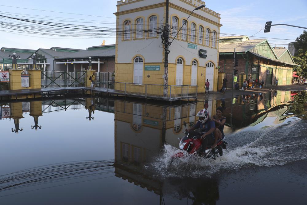
- Bradesco projeta aumento de dois dígitos em atendimentos, e Porto diz que clima dá mais prejuízo que roubo em residências
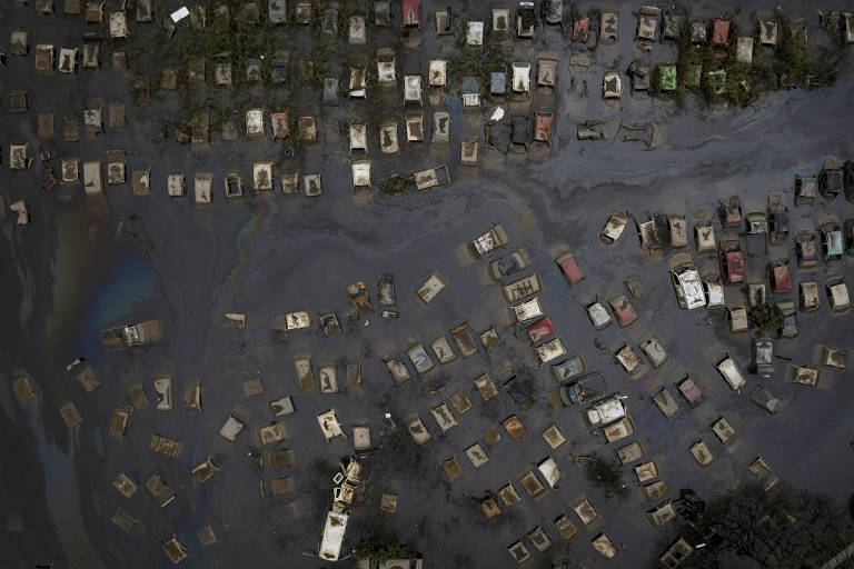
- Cobertura contra alagamentos ainda é baixa no país, mesmo depois do desastre no Rio Grande do Sul
26.jun.2026 às 6h00
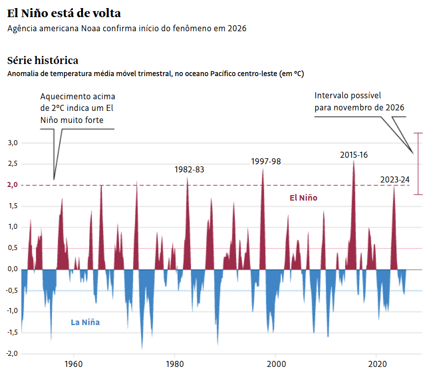
A chegada do El Niño já faz as seguradoras calcularem os impactos do fenômeno e se prepararem para um pico de indenizações. O setor residencial espera aumento de prejuízos ligados a chuvas, enquanto a seca deve elevar os acionamentos de apólices rurais.
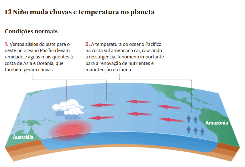
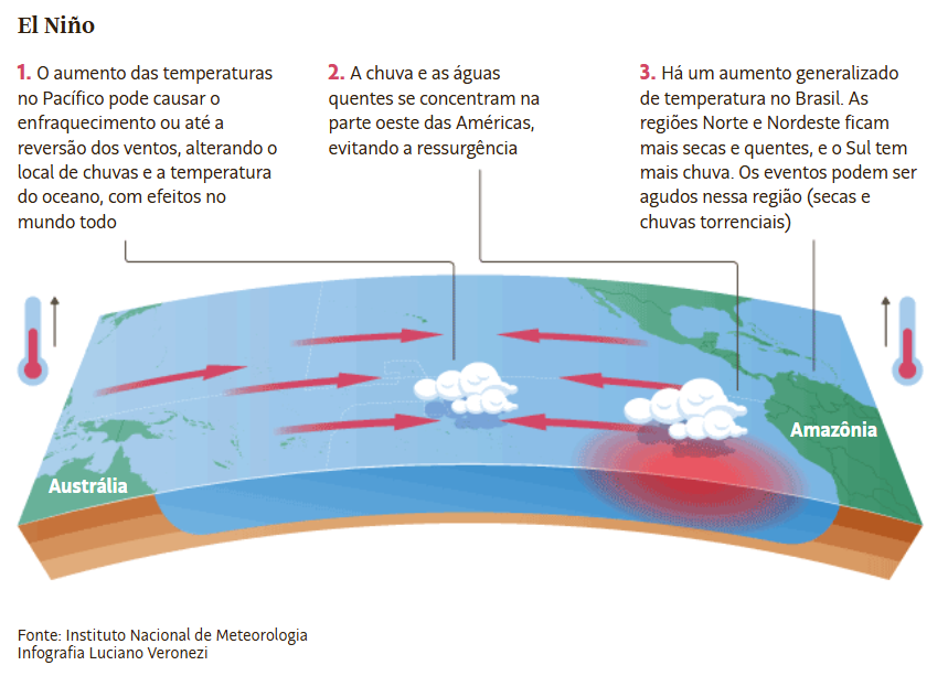
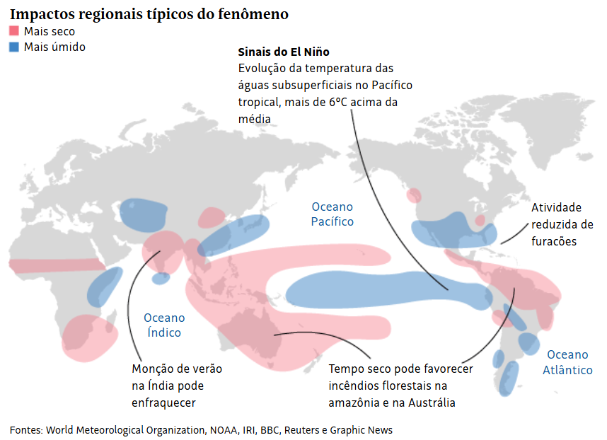
O El Niño é o aquecimento das águas do oceano Pacífico, que altera o clima do planeta. A Administração Nacional Oceânica e Atmosférica dos Estados Unidos confirmou o início do fenômeno no dia 11, com previsão de 63% de alcançar um nível muito forte de novembro a janeiro. A alta nas temperaturas globais tende a ampliar seus efeitos.
“Tudo indica que os maiores impactos nas carteiras de seguro residencial e patrimonial, como empresas e condomínios, serão na primavera, principalmente a partir de setembro e outubro”, diz Jarbas Medeiros, presidente da comissão de riscos patrimoniais massificados da FenSeg (Federação Nacional de Seguros Gerais).
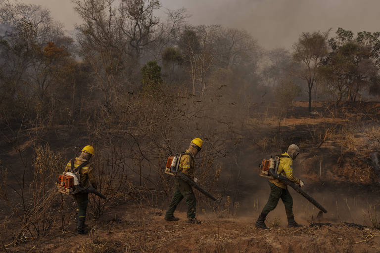
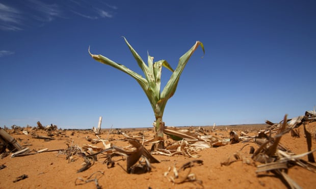
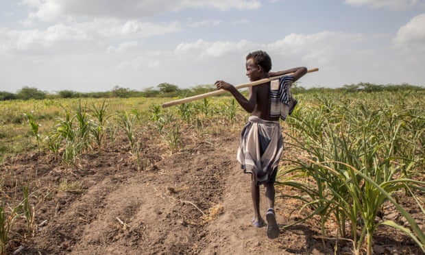
O cálculo do prejuízo depende das características de cada seguradora e da preparação das cidades atingidas, mas há clareza no setor residencial de que os maiores danos serão no Sul, onde chuvas fortes podem se tornar mais frequentes. No Norte e Centro-Oeste, o El Niño deve trazer mais seca e aumentar o risco de quebras de safra no agronegócio.
“Sabemos que podem acontecer eventos mais catastróficos em algumas regiões, e as seguradoras já começam a acompanhar isso muito de perto e a preparar suas estruturas, porque montamos uma força-tarefa para atendimento aos clientes em eventos extremos”, afirma Medeiros.
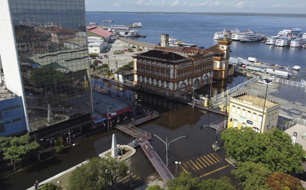
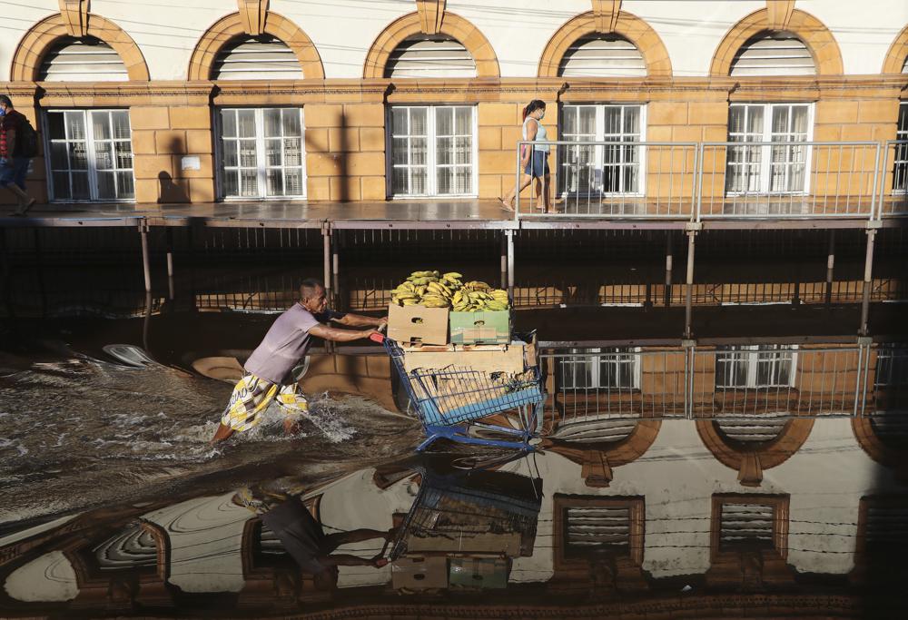
A última estimativa da FenSeg, de 2021, indicou que menos de 1% das residências do país tinha cobertura contra danos causados por alagamentos. Dados mais recentes das seguradoras apontam que a procura pela proteção aumentou, principalmente após o desastre no Rio Grande do Sul em 2024, mas os números ainda são baixos.
Sain’t Clair Lima, diretor de produtos da Bradesco Seguros, diz que de 4% a 6% das apólices residenciais da empresa cobrem inundações. A situação varia conforme a região: no Sul, a cobertura é de 6% a 7%.
“Se as previsões se confirmarem, deve ter aumento de pelo menos dois dígitos em relação à frequência de sinistros”, afirma Lima. Os sinistros são as ocasiões em que clientes sofrem danos e precisam acionar a seguradora para receber indenização.
Medeiros, que também atua como diretor de ramos elementares e vida na Porto Seguro, afirma que somente 3% das apólices residenciais da empresa incluem inundações. A cobertura alcança 50% para vendavais e 80% para danos elétricos devido a cortes de energia.
Segundo ele, dez seguradoras oferecem a proteção para alagamentos atualmente no Brasil, contra apenas três na época do desastre gaúcho.
“Embora essa seja uma cobertura bastante desafiadora do ponto de vista de subscrição e precificação, o mercado trabalha para ampliar a oferta, para que o cliente encontre nas seguradoras uma possibilidade de se proteger contra os eventos extremos”, diz.
Sinistros em condomínios e empresas também devem aumentar, e Medeiros afirma que a proteção contra alagamento nessas categorias não passa de 5% das carteiras.
De acordo com o diretor, 29% da receita com seguros residenciais da Porto Seguro vêm de coberturas de eventos climáticos, incluindo alagamento, vendaval e dano elétrico. Porém, 48% do valor pago em indenizações se deve a essas ocorrências, taxa superior ao montante indenizado por furtos ou roubos.
“Claramente são coberturas que trazem risco para a companhia, porque a proporção entre indenização e pagamento é maior”, afirma. “As pessoas têm medo de ser roubadas, de sair de férias e, quando voltar, ver que a casa foi arrombada. Mas, muitas vezes, não passa na cabeça que o que mais causa prejuízo é o evento climático”.
Adilson Lavrador, diretor-executivo de operações, sinistros e tecnologia da Tokio Marine, diz que a companhia acompanha as informações sobre o El Niño e que fenômenos climáticos podem impactar praticamente todo o ecossistema de seguros.
“Em cenários de enchentes severas, chuvas intensas e vendavais, os ramos de seguros patrimoniais, de automóvel e agrícola tendem a registrar elevação nas ocorrências”, afirma. “Em situações extremas, também impactam o seguro de vida”.
No agronegócio, os números mostram uma queda no valor pago pelos clientes às seguradoras. Daniel Nascimento, presidente da comissão de seguro rural da FenSeg, afirma que houve uma retração de 7% no valor do prêmio no primeiro trimestre de 2026, em relação ao mesmo período de 2025.
O setor também registra redução na área de lavouras protegidas: 3,2 milhões de hectares estavam segurados em 2025, menos da metade dos 7,1 milhões de hectares do ano anterior.
“As seguradoras vêm acompanhando de perto o El Niño e fazem um planejamento de vendas para não expor muito seu capital”, diz. “Nosso maior desafio é que o produtor não espere o próximo evento impactar a sua região [para contratar a proteção]”.
Lima, da Bradesco Seguros, afirma que os prejuízos do agro com eventuais perdas de safra não poderão ser totalmente compensados: “Por mais que o seguro consiga recompor de alguma forma a perda financeira, há uma preocupação com todo o ecossistema, principalmente o financeiro, porque vai faltar alimento no mercado e gerar inflação”.


")


 Segundo o secretário-geral adjunto da Organização Mundial de Meteorologia (OMM), Jeremiah Lengoasa, aquecimento das águas equatoriais do Oceano Pacífico, na altura do Peru e do Equador, provocará a formação de nuvens que tendem a ser arrastadas pelos ventos na direção contrária a América do Sul; fenômeno deve manter seca em SP em 2015
 Precipitation outlook for winter 2011-12, showing the likelihood of below average precipitation in Texas and other drought-stricken states.


COMENTÁRIOS
5 comentários em “Fenômeno “El Niño” deve prolongar seca em SP”
Os comentários aqui postados expressam a opinião
dos seus autores, responsáveis por seu teor, e não do 247
Wilians 28.10.2014 às 14:51
Eu e minha familia alugamos nossa casa em São Paulo e mudamos para o sertão da Bahia. Aqui está bom pra morar tem emprego e muita agua,e confesso pra voces,mesmo que São Paulo volte a ter agua,talves nos não voltaremos mais aqui é muito bom pra se viver,pois os baianos são um povo hospitaleiros.Detalhe:sou paulistano da 3ª geração.
JÁ OUVIU FALAR DE HAARP? GUERRA CLÍMATICA. 28.10.2014 às 12:56
http://amaivos.uol.com.br/amaivos09/noticia/noticia.asp?cod_canal=38&cod_noticia=25492 //////// E VEJA TAMBÉM EM: http://www.anovaordemmundial.com/2014/02/haarp-cientistas-advertem-que-eua-iniciaram-uma-guerra-climatica-contra-a-america-do-sul.html
Carlos Avelar 28.10.2014 às 12:03
Penso que o governador Alckmin tem que falar da questão hídrica com seriedade, notadamente diante do quadro de catástrofe que se avizinha. Evidente que o governo de SP sabia de tudo, mas por “compreensível” questão de manter o poder, abafou a discussão; evitando, assim, de forma desastrosa, que os paulistanos, principalmente esses, tomassem conhecimento da gravidade que é a questão de futuro e inevitável desabastecimento. Faltou coragem e honra ao sr. Alckmin quando deixou de tomar as medidas necessárias que durante muitos e muitos anos lhe foram demonstradas tecnicamente, porquanto necessárias. Quando, de fato, as torneiras – TODAS – começarem a secar, até mesmo as dos moradores “privilegiados”, pagarão os governantes do PSDB um preço alto e merecido pelo descaso e mentira perpetrados.
ISSO SÓ PODE SER CASTIGO DIVINO . . . . . . . 28.10.2014 às 11:54
. . . CONTRA ESSA QUADRILHA TUCANALHA QUE QUE GOVERNA OS ESTADOS AFETADOS PELA SECA: SÃO PAULO, MINAS GERAIS E PARANÁ……………………… NEM DEUS AGUENTA MaIS ESSA TURMA DE CORRUPTOS DA QUADRILHA TUCANALHA.
Vou Pro Nordeste! 28.10.2014 às 11:41
Lá tem água trazida pelo São Francisco! Vou pegar um pau-de-tucano e me mandar! KKKKKKKKKKKKKKKKKKKKKKKKKKKKKKK
* * *
RBA
Para especialista, Grande SP viverá dois anos de seca e vai perder o Cantareira
Se o volume morto for desconsiderado, as represas do Sistema Cantareira estariam com reservatórios a menos de 1%
São Bernardo do Campo – Má gestão e descuido provocaram uma situação de crise e degradação ambiental nos principais reservatórios de água da Grande São Paulo. O Sistema Cantareira, o primeiro a falecer com a estiagem, deve operar a partir de hoje (11) apenas com o chamado volume morto. Isso porque ontem atingiu 18,7% de sua capacidade – se o volume morto for desconsiderado, as represas desse sistema estariam com reservatórios a menos de 1%. Especialistas e órgãos que acompanham a situação do sistema argumentam que até 2015 as represas não devem se recuperar. Serão dois anos de seca para a metrópole.
No ABC paulista, o Sistema Rio Grande, braço da represa Billings, já está sofrendo as consequências da seca e mudanças na forma de abastecimento. Ontem, o reservatório, que até o mês passado estava em operação com mais de 95% de sua capacidade, apresentava 90%. O Alto Tietê, segundo da lista de estiagem, já está funcionando com apenas 24%.
O grupo técnico que acompanha a gestão das bacias paulistas vem alertando o governo estadual para a redução da retirada de água do Cantareira. O alerta se estendeu também para o Alto Tietê e outras bacias. Ao contrário da expectativa do governador Geraldo Alckmin (PSDB), o grupo apontou que o Cantareira tem baixa possibilidade de voltar à capacidade normal em 2015. Conforme boletim divulgado pelo grupo, as chances são de 25%.
Em três documentos expedidos desde maio, os técnicos solicitam “medidas de restrição de uso para usuários localizados nas bacias do PCJ (Piracicaba, Capivari e Jundiaí) e Alto Tietê”. Diante disso, a Sabesp (Companhia de Saneamento Básico de São Paulo) reduziu o volume captado no Cantareira, enquanto o governador incentivava os paulistanos a economizar no consumo de água em troca de descontos na conta mensal. Em todos os momentos, Alckmin garantiu que não recorreria ao racionamento.
Só volume morto
O diretor do Departamento de Hidrologia da Faculdade de Engenharia da Unicamp, Antônio Carlos Zuffo, explicou hoje que o Sistema Cantareira vai operar apenas com volume morto. Conforme o especialista, a estiagem de agora é cíclica e pode durar pelos próximos anos. “Entre as décadas de 1930 e 1960, o Cantareira passou por um período de seca. Depois veio um período menos seco, o que transmitiu uma falsa sensação de segurança”, lembrou.
Em 2004, segundo o professor, o estado ampliou a vazão do sistema e a capacidade foi consumida rapidamente. “O que houve foi uma super expectativa em um período de redução da precipitação pluviométrica”, disse.
Viável somente após cinco anos
“Se para resolver o problema de falta d’água em São Paulo o governo estadual deve recorrer à engenharia, o resultado não seria sentido em menos de cinco anos.” Essa é a perspectiva do professor Zuffo. Além disso, ele analisa que uma das táticas colocadas em prática por Alckmin pode não surtir efeito.
Para minimizar a retirada de água do Cantareira, o governador disse recentemente que conta com a “população e gestão”. “Estamos substituindo o Cantareira pelo Guarapiranga e Alto Tietê”, afirmou o governador em evento político na inauguração do trecho Leste do Rodoanel, semana passada. Conforme Alckmin, ainda neste mês será retirado 0,5 metro cúbico de água por segundo do Sistema Rio Claro, que abastecia Santo André, para atender à Grande São Paulo. Em setembro, o mesmo volume será captado no Rio Grande, na represa Billings. E em outubro, 1 metro cúbico por segundo do Sistema Guarapiranga. “Esse volume não conseguiria atender à Grande São Paulo”, salientou Zuffo, acrescentando que, somados os volumes, chegaria próximo à metade do que é consumido em Campinas.
“É uma política de governo militar: desenvolver os sistemas e depois pagar pelo prejuízo e degradação ambiental”, criticou o advogado e ecologista Virgílio Farias. “Se tivermos de esperar pela chuva aguardada pelo governador para encher o Cantareira, corremos risco de inundações”, argumentou, explicando que a solução seria apostar na despoluição da Billings e utilizar sua água.
Perto do ABC, a falta de água já é sentida nas casas. Na Vila Liviero, a menos de um quilômetro da divisa da capital com São Bernardo, ao menos uma vez por semana falta água. “Deixo de lavar o quintal, lavo roupa uma vez por semana e mesmo assim, quando não sai água da torneira, tenho de economizar ainda mais no consumo”, disse a dona de casa Maria Madalena Mediotti, 54 anos.