Arquivo da tag: Seca

National Science Foundation: Record California Drought Directly Linked To Climate Change (Climate Progress)

BY JOE ROMM

POSTED ON SEPTEMBER 29, 2014 AT 2:59 PM

NSF: “The drought crippling California is by some measures the worst in the state’s history.” CREDIT: NOAA

A Stanford study funded by the National Science Foundation (NSF) confirms a growing body of research that finds “The atmospheric conditions associated with the unprecedented drought in California are very likely linked to human-caused climate change.”

The NSF news release, headlined, “Cause of California drought linked to climate change,” explains:

Climate scientist Noah Diffenbaugh of Stanford University and colleagues used a novel combination of computer simulations and statistical techniques to show that a persistent region of high atmospheric pressure over the Pacific Ocean–one that diverted storms away from California–was much more likely to form in the presence of modern greenhouse gas concentrations.

Unprecedented droughts often combine a reduction in precipitation with higher temperatures that increase evaporation, leaving soil parched. As the NSF notes in this case, “Combined with unusually warm temperatures and stagnant air conditions, the lack of precipitation has triggered a dangerous increase in wildfires and incidents of air pollution across the state.”

We know, of course, that global warming is making heat waves longer and stronger and more frequent, which in turn makes droughts worse everywhere. But climate change is also causing reduced precipitation in many regions, such as the Mediterranean and southwestern United States. This double whammy from carbon pollution means we’ll be seeing more and more dangerous record droughts.

California’s 3-year drought has reached epic proportions. The L.A. Times reported last week, “Drought has 14 communities on the brink of waterlessness.”

Here’s the most recent Drought Monitor for the state:

20140923_CA_trd

So what is the proximate cause of the reduced precipitation over California? New studies suggest that increases in sea surface temperatures are not the cause of the drying. The NSF study, however, explains:

Scientists agree that the immediate cause of the drought is a particularly tenacious “blocking ridge” over the northeastern Pacific — popularly known as the Ridiculously Resilient Ridge, or “Triple R” — that prevented winter storms from reaching California during the 2013 and 2014 rainy seasons.

Blocking ridges are regions of high atmospheric pressure that disrupt typical wind patterns in the atmosphere.

The NSF study analyzed “the period since 1948, for which comprehensive atmospheric data are available.” Researchers “found that the persistence and intensity of the Triple R in 2013 were unrivaled by any previous event.” Stanford’s Bala Rajaratnam then “applied advanced statistical techniques to a large suite of climate model simulations.”

Finally, researchers looked at two sets of models — one set that duplicated the current climate, in which carbon pollution is warming the atmosphere, and the other set in which carbon pollution levels were comparable to those just before the Industrial Revolution.

The researchers found that the extreme heights of the Triple R in 2013 were at least three times as likely to occur in the present climate as in the preindustrial climate.

They also found that such extreme values are consistently tied to unusually low precipitation in California, and to the formation of atmospheric ridges over the northeastern Pacific.

Prof. Rajaratnam concluded, “We’ve demonstrated with high statistical confidence that large-scale atmospheric conditions similar to those of the Triple R are far more likely to occur now than in the climate before we emitted large amounts of greenhouse gases.”

This matches the finding in an April study that “there is a traceable anthropogenic warming footprint in the enormous intensity of the anomalous ridge during winter 2013-14, the associated drought and its intensity.” The lead author of that study, Dr. Simon Wang of the Utah Climate Center, told me in an email earlier this year, “I personally think that the debate over global warming leading to stronger blocking has passed. The ongoing challenge is how we predict WHEN and WHERE those blocking will happen and affect WHICH region.”

Indeed, as I’ve reported, scientists a decade ago not only predicted the loss of Arctic ice would dry out California, they also precisely predicted the specific, unprecedented change in the jet stream that has in fact caused the unprecedented nature of the California drought.

In fact, a growing body of evidence — documented by Senior Weather Channel meteorologist Stu Ostro and others — that “global warming is increasing the atmosphere’s thickness, leading to stronger and more persistent ridges of high pressure, which in turn are a key to temperature, rainfall, and snowfall extremes and topsy-turvy weather patterns like we’ve had in recent years.”

Bottom Line: Human activity has made droughts longer and stronger in many places, including California. If we continue on our current path of unrestricted carbon pollution, we will be sharply increasing the chances of civilization-threatening mega-droughts here and abroad.

California water witches see big business as the drought drags on (The Guardian)

Dowsers, sometimes known as ‘water witches,’ are in high demand in drought-stricken California, where four dry years find farmers and vintners taking desperate measures

Mary Catherine O’Connor

Monday 15 September 2014 07.00 BST

VIDEO:

Sharron Hope has been a dowser since 1997. Markedly cheaper than hiring a hydrogeologist – which can cost as much as $50,000 – Hope OFFERS her services for around $500 a consultation. Video: Mary Catherine O’Connor

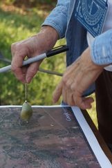
Outside of a farmhouse on a 1,800-acre organic dairy farm near Oroville, California, Sharron Hope bends over a printout of a Google Earth map, holding a small jade Buddha pendant. The map shows a small section of the farm to the east, and Hope is hunting for water. As the pendant swings, she notes a subtle change in motion that, she says, indicates she has found some.

Is there any significance to the jade? No, she says, I just like it. Plus, she adds, “I figure Buddha’s gotta know.”

Hope is a water dowser, or someone who uses intuition, energy VIBRATIONS and divining rods or pendulums to mark the best spots for wells.

As California rounds the corner towards a four-year historic drought, many farmers and vintners have become completely reliant on groundwater. After divvying surface water allotments to satisfy urban, ecosystem and industrial needs, farmers in many parts of the state received little or no irrigation water from state agencies this year. In a normal year, allotments would cover roughly two-thirds of farmers’ needs.

1Sharron Hope, a water dowser in California, uses a jade pendant to locate underground water on a map. Photograph: Mary Catherine O’Connor

Under these severe drought conditions, the success or failure of a well can mean the success or failure of a farm or vineyard, so before the drill bit hits the dirt, landowners need an educated guess as to where to find the most productive well site on their property. To get that, they can call in a professional hydrogeologist, which can cost tens of thousands of dollars – or they can drop a fraction of the cost on a dowser, such as Hope.

Despite a distinct lack of empirical evidence regarding dowsers’ efficacy, demand is high and dowsers’ phones are ringing off the hook.

“I’ve gotten far more calls this year from farmers looking for a water dowser than in most years,” says Sacramento-based Donna Alhers, who heads the Sierra Dowsers, a chapter of the American Society of Dowsers.

Water dowsers from around the state are also seeing a spike in demand. “I’m getting a lot of calls from people whose wells have run dry,” Hope says.

Where did dowsing come from?

The exact origins of dowsing are murky, but its roots can be traced back as far as the Middle Ages. The practice, sometimes used by miners and fortune seekers, was reportedly condemned in the 16th century as the work of the devil.

Today, dowsers hail from one of two camps. Some have agrarian backgrounds, and learned the practice from ancestors who used it to locate good sites for wells on their own or their neighbors’ farms. The second group hails from the New Age movement and tend to be devotees of a wide range of mystical practices and “energy work”.

Traditionally, dowsing has been used not just to find groundwater, but also minerals and natural gas. Many dowsers claim they can dowse anything, from lost items or pets to criminals on the lam. You name it, they say they can divine it.

Hope began dowsing for water in 1977 after learning about the practice from Walter Woods, a science teacher at Butte College, where she was a STUDENT. Woods had learned dowsing from his father, a farmer, and eventually became a well-known authority on dowsing. He authored a widely read dowsing primer, Letter to Robin, and served as president of the American Society of Dowsers.

Woods taught Hope to scan for signs of groundwater by observing the landscape and looking for signs like deer trails. “Deer have magnetite in their pineal gland [an endocrine gland in the brain]. As water moves underground, electrons are stripped out and move to the surface,” Hope says. “Deer can sense it and tend to walk along that vein of underground water toward a spring.” Dowsing is based on the premise that humans can tap into that energy, too, using instruments such as branches and pendulums.

Energy marks the spot

After Hope finishes with the map, she heads out to the spots she has marked, walking the land and searching for very faint energy markings over the landscape, which she’ll use more talismans to locate.

She begins a general scan of the area with a forked pine branch, holding the ends in her hands and sweeping it through the air. Despite scientific evidence, Hope believes that the branch she holds channels the energy emitted by submerged water. Once she homes in on the most promising region (which matches, as it turns out, the area she had marked on the map) she TRADES the branch for what are known in the dowsing world as “L-rods”, two long metal bars with a short handle and long extension, forming an L.

2Sharron Hope works as a dowser in California’s CENTRAL VALLEY. Here she uses a pine branch to lead her to to a potential well site. Photograph: Mary Catherine O’Connor

Hope holds these in front of her, with her elbows at 90 degrees, and walks slowly up – and then laterally along – the rise. As the long ends of the bars begin to fall away from each other, she stops.

The energy moving up from the groundwater, she says, creates a field that L-rods respond to. This, she says, marks the edge of the underground stream. She then traverses the hillside, down slope, and stops again when the bars cross in front of her. This, she explains, marks the spot where two veins of groundwater cross over each other, making it a potentially very productive well site.

“I have goosebumps,” Hope says with a smile. “I feel the energy moving up from the ground.”

Although Hope and other dowsers often refer to underground veins and streams, USGS hydrologist Ralph Health, in a highly cited report on groundwater basics, says the vast majority of groundwater is found in relatively still aquifers. Swiftly moving streams are quite rare.

Water, water everywhere

Out in the field, Hope locates three possible well sites in roughly 30 minutes. She decides that the third is the best option, even though she doesn’t think it has the strongest flow rate, because it is relatively shallow at 200 feet (about 61 meters) below ground and is the most accessible and FLAT option. Daley stakes the spot and the dowsing is done. Daley is now awaiting drilling permits, and once those come through, she’ll call in a local driller.

“I have about 90% accuracy,” Hope claims, meaning that 90% of the sites she recommends produce water.

This actually isn’t that surprising, hydrogeologists say. “Dowsers may seem convincing, but when [their practice is] exposed to scientific review, groundwater is very prevalent, so it’s hard to miss it when you drill a well,” says Ted Johnson, chief hydrogeologist for the Water Replenishment District of Southern California and president of the board of the Groundwater Resources Association of California. “When you use science to site a well, you can test for quality, depth and how long [the flow] will last.”

To site a well, hydrogeologists will review driller well logs from the Department of Water Resources and geologic maps that show areas of alluvial soils, under which groundwater is most likely to accumulate. To really zero in on well sites, they drill a test well, which produces cuttings of the various strata. They then test for each layer’s ability to transport water. It’s a time-consuming and expensive process.

Because a landowner is unlikely to hire both a dowser and a hydrogeologist to see who finds the best-producing well (though that could make for some mildly entertaining reality television), the two groups coexist and generally ignore each other, aside from tossing verbal jabs.

“I’m a scientist and I’ve been trained on scientific principles, and that’s what I use [to locate groundwater],” says Tim Parker, a hydrogeologist and independent consultant based in Sacramento. “There’s no scientific evidence that dowsing is more effective than random chance.”

Of cash and crops

So why are so many farmers turning to dowsers instead of hydrologists? Part of it’s probably the money: dowsers might charge $1,000 (Hope charges most of her clients around $500, and less for a small residential well), while a big consulting firm costs $10,000 to $50,000, Johnson says. “All a farmer cares about is getting the groundwater,” he says.

But Cynthia Daley, who hired Sharron Hope to dowse for a well on her dairy farm, says it’s not about costs. “Dowsing is based on energy and it is something that the scientific community has not embraced, but I’m not arrogant enough to think science knows everything – and I am a scientist; I have a PhD,” she says.

Whether farmers and vintners are using dowsers merely as a result of their relative affordability or out of a strong belief in the practice is hard to, well, divine. What is clear is that the popularity of dowsing is growing, not just in the CENTRAL VALLEY, but throughout the state.

Daley, who has degrees in animal science with a doctorate in endocrinology, is a professor in the College of Agriculture at nearby California State University at Chico, where she runs an organic dairy program. She is developing an organic dairy operation on her property, which is why she’s drilling wells. “Everyone I know who has had wells put in around here has used dowsers.”

Many more wells are springing up. State agencies from counties around California are issuing twice – and sometimes three times as many – well drilling permits this summer than last summer, according to the Associated Press.

Keeping Marc Mondavi busy

Marc Mondavi, grandson of Napa Valley WINE pioneer Cesare Mondavi and a longtime dowser, says that he can’t keep up with the demand: “I’m doing anywhere from two to four projects a week and I’m backlogged, and drillers around here are backlogged for three to five months.”

Mondavi uses dowsing not only as a revenue stream, but also as a means of marketing his own brand, The Divining Rod. He doesn’t shy away from the name “water witch”, a term other dowsers consider pejorative. His daughter Alycia Mondavi even made a short promo VIDEO CALLED “My Dad is a Witch.”

He acknowledges it’s hard not to strike groundwater, but says that using his intuitive dowsing skills allows him to find the best spots, especially as the drought depletes the water table. “No matter where you drill, you might hit [a flow of] four gallons per minute,” he says. “In those areas maybe I can find eight to 10 gallons per minute.”

The dowsing divide might persist for decades to come, but there is plenty of indisputable evidence that groundwater is being overtaxed as the drought drags on. Amplifying the problem of groundwater scarcity, policy experts say, is a lack of regulation. That looks likely to change. Governor Brown is expected to sign one of three separate groundwater regulation bills currently sitting on his desk.

Some agriculture groups, including the Agriculture Council of California and Blue Diamond Growers, have rallied against the bills, saying they will drive up costs for already cash-strapped farmers and deny long-held water rights.

But Daley says groundwater is too important to remain unchecked. “We have to regulate it. It’s a very important resource.”

Until that happens, however, sun-baked farmers will keep digging for rain.

Mary Catherine O’Connor is an independent reporter and co-founder of Climate Confidential.

The Vital Signs platform is funded by Avery Dennison, Domtar and Chiquita. All content is editorially independent except for pieces labelled advertisement feature. Find out more here.

Racionamento de água ‘não é culpa de São Pedro’, diz ONU (OESP)

09/09/2014, 12h41

4.set.2014 – Represa Jaguari-Jacareí, na cidade de Joanópolis, no interior de São Paulo, teve o índice que mede o volume de água armazenado no Sistema Cantareira alcançando a marca de apenas 10,6% da capacidade total. Luis Moura/ Estadão Conteúdo

O racionamento de água em São Paulo não é culpa de São Pedro, mas, sim, das autoridades, da Companhia de Saneamento Básico do Estado de São Paulo (Sabesp) e da falta de investimentos. Quem faz o alerta é a relatora da Organização das Nações Unidas (ONU) para o direito à água, a portuguesa Catarina Albuquerque, que apresentou nesta terça-feira, 9, diante da entidade, um informe em que acusa o governo brasileiro de não estar cumprindo seu dever de garantir o acesso à água à totalidade da população.

Crise no abastecimento

“O culpado parece ser sempre São Pedro”, ironizou em declarações ao jornal O Estado de S. Paulo. “Concordo que a seca pode ser importante. Mas o racionamento de água precisa ser previsto e os investimentos necessários precisam ser feitos”, disse. “A responsabilidade é do Estado, que precisa garantir investimentos em momentos de abundância”, insistiu.

Segundo ela, o racionamento de fato pode ser necessário em algumas situações. “Mas apenas como última opção e depois que as demais opções tenham sido esgotadas”, alertou.

Reservatórios de água na Grande SP

 
Arte/UOL

Confira entre quais reservatórios se divide o abastecimento de água na Grande São Paulo

Raio-x dos sistemas

Para a relatora da ONU, não faz sentido a Sabesp ter suas ações comercializadas na Bolsa de Nova York e na Bolsa de Valores de São Paulo (Bovespa), enquanto a cidade convive com problemas. “Antes de repartir lucros, a empresa precisa investir para garantir que todos tenham acesso à água”, declarou.

“O número de pessoas vivendo sem acesso à água e saneamento às sombras de uma sociedade que se desenvolve rapidamente ainda é enorme”, declarou a relatora em seu discurso na ONU, nesta tarde em Genebra.

Segundo seu informe, um abastecimento de água regular e de qualidade ainda é uma realidade distante para 77 milhões de brasileiros, uma população equivalente a todos os habitantes da Alemanha.

21.ago.2014 – Escavadeira tenta retirar lixo do rio Tietê. Menos de um mês depois de finalizar uma operação que retirou mais de 18 toneladas de lixo de áreas do leito seco do rio Tietê, o município de Salto (a 101 km da capital paulista) começa a ver as áreas serem novamente tomadas por entulho. A maioria do material é de pedaços de madeira. Segundo o secretário de Meio Ambiente do município, João De Conti Neto, a sujeira está voltando pela correnteza. João De Conti Neto/Acervo Pessoal

A ONU ainda aponta que 60% da população – 114 milhões de pessoas – “não tem uma solução sanitária apropriada”. Os dados ainda revelam que 8 milhões de brasileiros ainda precisam fazer suas necessidades ao ar livre todos os dias.

O Estadão revelou em junho de 2013 que a representante das Nações Unidas teve sua primeira inspeção para realizar o levantamento vetada pelo governo. A visita estava programada para ocorrer em julho do ano passado. “O governo apenas explicou que, por motivos imprevistos, a missão não poderia mais ocorrer”, declarou à época Catarina de Albuquerque.

Internamente, a ONU considerou que o veto tinha uma relação direta com os protestos que, em 2013, marcaram as cidades brasileiras. A viagem só aconteceria em dezembro de 2013, o que impediria que o informe produzido fosse apresentado aos demais governos da ONU e à sociedade civil antes da Copa do Mundo.

Agora, o raio X reflete uma crise que vive o País no que se refere ao acesso a água e saneamento. “Milhões de pessoas continuam vivendo em ambientes insalubres, sem acesso à água e ao saneamento”, indicou o informe, apontando que o maior problema estaria nas favelas e nas zonas rurais.

Resposta

O governo brasileiro indicou que o acesso à água e ao saneamento é “uma prioridade”, que a população mais pobre recebe uma atenção especial e que o governo tem “aumentado de forma significativa os investimentos em saneamento ao transferir recursos para Estados e municípios”.

“Houve um aumento nos orçamentos de fundos especiais para promover investimentos em infraestrutura de água e saneamento”, indicou a embaixadora do Brasil na ONU, Regina Dunlop.

“Temos um compromisso com a eliminação de desigualdades, dando prioridades para os mais vulneráveis”, insistiu a diplomata, indicando que as populações das favelas não são esquecidas.

Entre as medidas, a diplomata aponta investimentos de R$ 21,5 bilhões pelo governo em moradia, acesso à água, serviços de esgoto e revitalização urbana.

O governo também sugere que a relatora fizesse uma viagem mais ampla ao Brasil e alerta para a dimensão do território nacional.


United Nations predicts climate hell in 2050 with imagined weather forecasts (The Guardian)

‘Reports from the future’ warn of floods, storms and searing heat in campaign for climate change summit

The Guardian, Monday 1 September 2014 19.18 BST

Texas drought warning

Signs warning of drought and high temperatures in Texas. The UN has predicted climate hell by 2050. Photograph: Mike Stone/Reuters

The United Nations is warning of floods, storms and searing heat fromArizona to Zambia within four decades, as part of a series of imagined weather forecasts released on Monday for a campaign publicising a UN climate summit.

“Miami South Beach is under water,” one forecaster says in a first edition of “weather reports from the future“, a series set in 2050 and produced by companies including Japan’s NHK, the US Weather Channel and ARD in Germany.

The UN World Meteorological Organization, which invited well-known television presenters to make videos to be issued before the summit on 23 September, said the scenarios were imaginary but realistic for a warming world.

A Zambian forecaster, for instance, describes a severe heatwave and an American presenter says: “The mega-drought in Arizona has claimed another casualty.”

Some, however, show extreme change. One Bulgarian presenter shows a red map with temperatures of 50C (122F) – far above the temperature record for the country of 45.2C (113F) recorded in 1916.

Climate change is affecting the weather everywhere. It makes it more extreme and disturbs established patterns. That means more disasters; more uncertainty,” the UN secretary general, Ban Ki-moon, said in a statement.

Ban has asked world leaders to make “bold pledges” to fight climate change at the meeting in New York. The summit is meant as a step towards a deal by almost 200 nations, due by the end of 2015, to slow global warming.

A UN report last year concluded it is at least 95% probable that human activities, rather than natural variations in the climate, are the main cause of global warming since 1950.

Falta de água é culpa do governo de SP, afirma relatora da ONU (Folha de S.Paulo)

LUCAS SAMPAIO

DE CAMPINAS

31/08/2014 02h15

Relatora das Nações Unidas para a questão da água, a portuguesa Catarina de Albuquerque, 44, afirma que a grave crise hídrica em São Paulo é de responsabilidade do governo do Estado. “E não sou a única a achar isso.”

Ela visitou o Brasil em dezembro de 2013, a convite do governo federal.

De volta ao país, ela falou com a Folha na semana passada em Campinas, após participar de um debate sobre a crise da água em São Paulo.

Eduardo Anizelli/Folhapress
Relatora das Nações Unidas para a questão da água, Catarina de Albuquerque

A gestão Geraldo Alckmin (PSDB) nega que faltem investimentos e atribui a crise à falta de chuvas nos últimos meses, que classifica como “excepcional” e “inimaginável”.

A seguir, trechos da entrevista à Folha.

*

Folha – Que lições devemos tirar desta crise?
Catarina de Albuquerque – Temos de nos planejar em tempos de abundância para os tempos de escassez. E olhar para a água como um bem precioso e escasso, indispensável à sobrevivência humana.
Em Singapura, no Japão e na Suíça, a água do esgoto, tratada, é misturada à água comum. É de excelente qualidade. Temos de olhar o esgoto como recurso.

No caso de São Paulo, acha que faltou ao governo do Estado adotar medidas e fazer os investimentos necessários?
Acho que sim, e não sou a única. Já falei com vários especialistas aqui no Brasil que dizem exatamente isso. Admito que uma parte da gravidade poderia não ser previsível, mas a seca, em si, era. Tinha de ter combatido as perdas de água. É inconcebível que estejam quase em 40% [média do país].

A água deveria ser mais cara? Há modelos de cobrança mais adequados do que o atual?
A prioridade tem de ser as pessoas. Quem usa a água para outros fins tem mais poder que os mais pobres, que têm de ter esse direito garantido.

Em muitos países, a água é mais cara para a indústria, a agricultura e o turismo, por exemplo. Deveria haver também um aumento exponencial do preço em relação ao consumo, para garantir que quem consome mais pague muitíssimo mais.

Que exemplos poderiam inspirar os governos?
Os EUA multam quem lava o carro em tempos de seca; a Austrália diz aos agricultores que não há água para todos em situações de emergência; e no Japão há sistemas de canalização paralela para reutilizar a água.

Qual é a importância de grandes obras como a transposição do rio São Francisco ou o sistema Cantareira?
Por várias razões, há uma atração pelas megaobras nos investimentos feitos em água e esgoto, não só no Brasil. Mas elas, muitas vezes, não beneficiam as pessoas que mais precisam de ajuda. Para isso são necessárias intervenções de pequena escala, que são menos “sexy” de anunciar.

Os lucros da Sabesp hoje são distribuídos aos acionistas. Como a senhora avalia isso diante da crise hídrica?
A legislação brasileira determina que uma empresa pública distribua parte do lucro aos acionistas. Mas uma coisa é uma empresa pública que faz parafusos, outra é uma que fornece água, que é um direito humano. As regras deveriam ser diferentes.

O marco normativo dos direitos humanos determina que sejam investidos todos os recursos disponíveis na realização do direito.

No caso de a empresa pública prestar um serviço que equivale a um direito humano, deveria haver maior limitação na distribuição dos lucros aos acionistas.

Em São Paulo, pela perspectiva dos direitos humanos, os recursos deveriam estar sendo investidos para garantir a sustentabilidade do sistema e o acesso de todos a esse direito.

A partir do momento em que parte desses recursos são enviados a acionistas, não estamos cumprindo as normas dos direitos humanos e, potencialmente, estamos face a uma violação desse direito.

Seria o caso de se decretar estado de calamidade pública?
A obrigação é garantir água em quantidade suficiente e de qualidade a todos. Como se chega lá são os governantes que devem saber.

A senhora sobrevoou o sistema Cantareira e disse ter visto muitas piscinas no caminho. O que achou disso?
A situação é grave. Isso foi algo que me saltou à vista.

Quando aterrissei no Egito para uma missão, tendo ciência da falta de água que existe no país, vi nas zonas ricas do Cairo uma série de casas com piscinas e pessoas lavando carros. Quem tem dinheiro e poder não sente falta de água.

O que talvez seja um pouco diferente na situação de São Paulo é que, pela proporção que a crise tomou, ela poderá atingir pessoas que tradicionalmente não sofrem limitação no uso da água -e isso é interessante.

Que efeito isso pode ter?
Pode levar a uma mudança de mentalidade, a uma pressão por parte de formadores de opinião no Estado de São Paulo para que haja melhor planejamento e uma gestão sustentável da água.

Quando os únicos que sofrem com a falta de água são pobres, pessoas que não têm voz na sociedade, as coisas não mudam.

Quando as pessoas que são ameaçadas com a falta de água são as com poder, com dinheiro, com influência, aí as coisas podem mudar, porque eles começam a sentir na pele. Pode ser uma chance para melhorar a situação. As crises são oportunidades.

Water ‘thermostat’ could help engineer drought-resistant crops (Science Daily)

Date: August 27, 2014

Source: Duke University

Summary: A gene that could help engineer drought-resistant crops has been identified by researchers. The gene, called OSCA1, encodes a protein in the cell membrane of plants that senses changes in water availability and adjusts the plant’s water conservation machinery accordingly. The findings could make it easier to feed the world’s growing population in the face of climate change. 


Duke University researchers have identified a gene that could help scientists engineer drought-resistant crops. The gene, called OSCA1, encodes a protein in the cell membrane of plants that senses changes in water availability and adjusts the plant’s water conservation machinery accordingly.

“It’s similar to a thermostat,” said Zhen-Ming Pei, an associate professor of biology at Duke.

The findings, which appear Aug. 28 in the journalNature, could make it easier to feed the world’s growing population in the face of climate change.

Drought is the major cause of crop losses worldwide. A dry spell at a crucial stage of the growing season can cut some crop yields in half.

Water shortages are expected to become more frequent and severe if climate change makes rainfall patterns increasingly unreliable and farmland in some regions continues to dry up. Coupled with a world population that is expected to increase by two billion to three billion by 2050, researchers worldwide are looking for ways to produce more food with less water.

Some researchers hope that genetic engineering — in addition to improved farming practices and traditional plant breeding — will add to the arsenal of techniques to help crops withstand summer’s swelter. But engineering plants to withstand drought has proven difficult to do, largely because plants use so many strategies to deal with dehydration and hundreds of genes are involved.

The problem is confounded by the fact that drought is often accompanied by heat waves and other stresses that require different coping strategies on the part of the plant, Pei said.

One way that plants respond to water loss is by boosting the levels of calcium within their cells. The calcium surge acts as an alarm signal that triggers coping mechanisms to help the plant rebalance its water budget. But until now, the molecular machinery that plants use to send this signal — and monitor water availability in general — remained unknown.

Pei and Duke colleagues Fang Yuan, James Siedow and others identified a gene that encodes a protein in the cell membranes of plant leaves and roots, called OSCA1, which acts as a channel that allows calcium to surge into the cell in times of drought.

The gene was identified in Arabidopsis thaliana, a small unassuming plant related to cabbage and canola that is the lab rat of plant research.

Plants with defective versions of the calcium channel don’t send an alarm signal under water stress like normal plants do.

When the researchers grew normal plants and plants with defective versions of the gene side by side in the same pot and exposed them to drought stress, the mutant plants experienced more wilting.

The findings could lead to new ways to help plants thrive when water is scarce.

The team’s next step is to manipulate the activity of the OSCA1 gene and related genes and see how those plants respond to drought — information that could lead to crops that respond more quickly and efficiently to dehydration.

“Plants that enter drought-fighting mode quickly and then switch back to normal growth mode quickly when drought stress is gone should be able to allocate energy more efficiently toward growth,” Pei said.


Journal Reference:

  1. Fang Yuan, Huimin Yang, Yan Xue, Dongdong Kong, Rui Ye, Chijun Li, Jingyuan Zhang, Lynn Theprungsirikul, Tayler Shrift, Bryan Krichilsky, Douglas M. Johnson, Gary B. Swift, Yikun He, James N. Siedow, Zhen-Ming Pei. OSCA1 mediates osmotic-stress-evoked Ca2 increases vital for osmosensing in Arabidopsis.Nature, 2014; DOI: 10.1038/nature13593

Southwest U.S. may face ‘megadrought’ this century (Science Daily)

Date: August 27, 2014

Source: Cornell University

Summary: Because of global warming, scientists say, the chances of the southwestern United States experiencing a decade long drought is at least 50 percent, and the chances of a “megadrought” — one that lasts over 30 years — ranges from 20 to 50 percent over the next century. 

Risk of megadrought in Southwestern U.S. Credit: Toby Ault, Cornell University; From “Assessing the risk of persistent drought using climate model simulations and paleoclimate data”

Because of global warming, scientists say, the chances of the southwestern United States experiencing a decade long drought is at least 50 percent, and the chances of a “megadrought” — one that lasts over 30 years — ranges from 20 to 50 percent over the next century.

The study by Cornell University, University of Arizona and U.S. Geological Survey researchers will be published in a forthcoming issue of the American Meteorological Society’s Journal of Climate.

“For the southwestern U.S., I’m not optimistic about avoiding real megadroughts,” said Toby Ault, Cornell assistant professor of earth and atmospheric sciences and lead author of the paper. “As we add greenhouse gases into the atmosphere — and we haven’t put the brakes on stopping this — we are weighting the dice for megadrought conditions.”

As of mid-August, most of California sits in a D4 “exceptional drought,” which is in the most severe category. Oregon, Arizona, New Mexico, Oklahoma and Texas also loiter between moderate and exceptional drought. Ault says climatologists don’t know whether the severe western and southwestern drought will continue, but he said, “With ongoing climate change, this is a glimpse of things to come. It’s a preview of our future.”

Ault said that the West and Southwest must look for mitigation strategies to cope with looming long-drought scenarios. “This will be worse than anything seen during the last 2,000 years and would pose unprecedented challenges to water resources in the region,” he said.

In computer models, while California, Arizona and New Mexico will likely face drought, the researchers show the chances for drought in parts of Washington, Montana and Idaho may decrease.

Beyond the United States, southern Africa, Australia and the Amazon basin are also vulnerable to the possibility of a megadrought. With increases in temperatures, drought severity will likely worsen, “implying that our results should be viewed as conservative,” the study reports.

“These results help us take the long view of future drought risk in the Southwest — and the picture is not pretty. We hope this opens up new discussions about how to best use and conserve the precious water that we have,” said Julia Cole, UA professor of geosciences and of atmospheric sciences.

The study, “Assessing the Risk of Persistent Drought Using Climate Model Simulations and Paleoclimate Data,” was also co-authored by Julia E. Cole, David M. Meko and Jonathan T. Overpeck of University of Arizona; and Gregory T. Pederson of the U.S. Geological Survey.

The National Science Foundation, National Center for Atmospheric Research, the U.S. Geological Survey and the National Oceanic and Atmospheric Administration funded the research.


Journal Reference:

  1. Toby R. Ault, Julia E. Cole, Jonathan T. Overpeck, Gregory T. Pederson, David M. Meko. Assessing the risk of persistent drought using climate model simulations and paleoclimate data. Journal of Climate, 2014; 140122102410007 DOI: 10.1175/JCLI-D-12-00282.1

Cacique cobra rapidez (Isto É Dinheiro)

29/08/2014

Por: Clayton Netz

Um relatório confidencial foi encaminhado ao governador de São Paulo, Geraldo Alckmin, ao prefeito da capital, Fernando Haddad, e à presidenta Dilma Rousseff. Elaborado pela Fundação Cacique Cobra Coral, traz notícias nada agradáveis sobre a previsão de chuvas para o próximo trimestre e para o ano de 2015. Fala de atraso no período chuvoso e precipitações irregulares no Centro-Sul. E cobra rapidez na assinatura de convênios que ajudariam a amenizar a situação, mas que estão parados em função do calendário eleitoral.

(Nota publicada na Edição 880 da Revista Dinheiro, com colaboração de: Carlos Eduardo Valim, Fabrício Bernardes e Vera Ondei)

A crise hídrica em São Paulo (Envolverde)

22/8/2014 – 04h28

por Heitor Scalambrini Costa*

represa cantareira 300x150 vale esta A crise hídrica em São Paulo

Contra fatos não há argumentos. O que acontece atualmente com relação ao desabastecimento de água em São Paulo se enquadra na retórica de que uma mentira repetida muitas vezes acaba virando verdade.

O governo paulista insiste em negar que se as obras necessárias tivessem sido realizadas poderia ser menos dramática a atual situação. E insiste ainda em responsabilizar São Pedro pelo caos evidente. A culpa não é da seca! A seca é parte do problema, pois desde sempre se soube que ela poderia vir.

Os gestores públicos também negam que existe racionamento, afirmando que o abastecimento de água está garantido até março de 2015, apesar de, na prática, o racionamento existir oficialmente em dezenas de municípios.

Em visita ao interior de São Paulo, no inicio de agosto [2014], pude constatar uma situação que ainda não tinha me dado conta. A gravidade da crise hídrica atinge não apenas a região metropolitana da capital, como a imprensa dá a entender ao enfatizar o colapso do sistema Cantareira, mas atinge todo o Estado mais rico da União.

Dos 645 municípios paulistas, a Sabesp (Companhia de Saneamento Básico de São Paulo) é responsável por fornecer água a 364, quem somam um total de 27,7 milhões de pessoas. Nos outros 281 municípios (não abastecidos pela Companhia), o abastecimento de água a 16 milhões de pessoas fica a cargo das próprias prefeituras ou de empresas por elas contratadas.

Se, por um lado, a companhia estadual de abastecimento nega haver adotado rodízio de água em qualquer um dos municípios atendidos por ela, inclusive na capital, tal afirmação é logo desmentida pelos usuários que relatam interrupções no abastecimento, principalmente à noite.

Nos municípios não atendidos pela Sabesp, medidas restritivas estão sendo tomadas por centenas de empresas e gestores locais devido à crise. Em Guarulhos, na grande São Paulo, o abastecimento de 1,3 milhões de moradores é atendido por um serviço municipal, o SAAE (Serviço Autônomo de Água e Esgoto), e seus moradores passam sem água um em cada dois dias.

Em 18 municípios, cerca de 2,1 milhões de pessoas estão submetidas ao racionamento oficial no estado de São Paulo, correspondendo a 5% da população total, segundo levantamento do jornal Folha de São Paulo (11/Ago). Além do racionamento, medidas de incentivo à economia de água têm sido adotadas, indo desde multas para reprimir o desperdício a campanhas com rifas de carro e TV para quem poupar e reduzir o consumo voluntariamente.

O que chama a atenção de todos, além da dimensão estadual da crise hídrica em São Paulo, é a insistência dos gestores em negar a existência do racionamento na área de atuação da Sabesp – mesmo contestados pelos moradores, que sofrem na prática com o rodízio provocado pela companhia, com cortes crescentes no fornecimento de água.

A contrapartida do poder é a ação responsável. E o governo paulista tem se mostrado irresponsável com o seu povo, além de incompetente e medíocre para resolver questões básicas para a sua população. É hora de assumir a gravidade da situação e dos erros cometidos, e, naturalmente, fazer as obras urgentes e necessárias para garantir o fornecimento seguro deste bem fundamental à vida.

Chega de hipocrisia, chega de culpar São Pedro que não pode se defender.

* Heitor Scalambrini Costa é professor Associado da Univ. Fed. de Pernambuco. Graduado em Física pela UNICAMP. Doutor em Energética na Univ. de Marselha/Comissariado de Energia Atômica-França.

** Publicado originalmente no site IHU On-Line.

Sudeste, rumo à desertificação (Envolverde)

29/7/2014 – 12h08

por Julio Ottoboni*

secawiki 300x204 Sudeste, rumo à desertificação

O sudeste do Brasil, parte da região central e do sul caminham para se tornar desérticas. A seca registrada este ano na porção centro-sul, principalmente em São Paulo, está ligada a permanente e acelerada degradação da floresta amazônica. O transporte de umidade para as partes mais ao sul do continente está sendo comprometida, pois além de sua diminuição é trazido partículas geradas nos processos de queimadas que impedem a formação de chuvas.

Os cientistas do (Instituto Nacional de Pesquisas Espaciais (Inpe) e do Instituto de Pesquisas da Amazônia (Inpa) há mais de uma década fizeram esse alerta, que a cada ano está pior e mais grave. E coloca em confronto o modelo econômico agropecuário, baseado em commodities, com a área mais industrializada, produtiva e rica do país. E também a mais urbanizada e detentora de 45% da população brasileira e abrigada em apenas 10,5% do território nacional.

O cientista e doutor em meteorologia do Inpe, Gilvam Sampaio de Oliveira, a situação é preocupante e bem mais grave do imaginado em relação a eventos extremos. A comunidade científica está surpresa com a dinâmica das alterações do clima. O número de desastres naturais vem crescendo. Entre 1940 e 2009 houve uma curva ascendente de inundações e o número de dias frios, principalmente em São Paulo, está em franca decadência.

“As questões que já estamos passando, como essa seca, eram projetadas para daqui há 15 ou 20 anos. A área de altas temperaturas está aumentando em toda América do Sul. Em São Paulo e São José dos Campos, por exemplo, há um aumento de chuvas com mais de 100 milímetros concentradas e períodos maiores sem precipitação alguma. E quanto mais seca a região, aumenta o efeito estufa e diminui a possibilidade de chuvas”, alertou o cientista.

O sistema principal formador do ciclo natural que abastece a pluviometria do sudeste começa com a massa de ar quente repleta de umidade, formada na bacia do Amazonas, seguindo até os Andes. Com a barreira natural, ela retorna para a porção sul continental, o que decreta o regime de chuvas.

A revista científica Nature publicou em 2012 um estudo inglês da Universidade de Leeds. O artigo apresentou o resultado de um estudo no qual os mais de 600 mil quilômetros quadrados de floresta amazônica perdidos desde a década de 1970, e com o avanço do desmatamento seguido de queimadas cerca de 40% de todo complexo natural, estará extinto até 2050. Isso comprometerá o regime de chuvas, que seriam reduzidas em mais de 20% nos períodos de seca.

Faixa dos desertos

O sudeste brasileiro está na faixa dos desertos existente no hemisfério sul do planeta. Ela atravessa enormes áreas continentais, como os desertos australianos de Great Sendy, Gibson e Great Victoria, na plataforma africana surgem as áreas desertificadas da Namíbia e do Kalahari e na América do Sul, o do Atacama. Sem qualquer coincidência, ambos desertos africanos, inclusive em expansão, estão alinhados frontalmente, dentro das margens latitudinais, com as regiões dos Estados do Sudeste e do Sul do país.

Essa porção territorial só se viu livre da desertificação com o êxito da Amazônia e a formação da Mata Atlântica. Ambas foram determinantes para se criar um regime de chuvas que mantiveram essas partes do Brasil e da América do Sul com solos férteis e índices pluviométricos mais que satisfatórios à manutenção da vida.

O geólogo do Inpe  e assessor da Agência Espacial Brasileira (AEB), Paulo Roberto Martini,  tem sua teoria para esse fenômeno. Na qual a desertificação destas regiões ocorrerá se o transporte de ar úmido for bloqueado ou escasseado, por ação natural ou antrópica. Exatamente o que vem acontecendo. As investigações geomorfológicas já mostraram que entre os anos 1000 e 1300 houveram secas generalizadas e populações inteiras desaparecerem nas Américas. E isto pode ocorrer novamente, agora potencializado pela devastação causada pelo homem.

“Esse solo da região Sul e Sudeste tem potencial enorme para se tornar deserto, basta não chover regularmente. A distribuição da umidade evitou que essa região da América do Sul fosse transformada num imenso deserto”, explicou Martini.

Segundo o pesquisador, no fim do período glacial, por volta de 12 mil anos, a cobertura do Brasil teria sido predominantemente de savana, como na África, pobre em diversidade e formada por gramíneas e poucas espécies arbóreas. O que ainda é encontrado no interior de São Paulo, Minas Gerais, Espírito Santo e no Mato Grosso. Entretanto, a umidade oceânica associada à amazônica possibilitou a constituição da Mata Atlântica e seu ingresso continente adentro.

A penetração da flora em áreas de campo realimentou o ciclo das chuvas, nível de umidade das áreas ocupadas e a fertilização do solo. Em milhares de anos formou-se um vasto complexo florestal, atualmente reduzido a menos de 5% de seu tamanho original na época do descobrimento.

“Há uma cultura de degradação e falar em restauração das matas no Brasil é ficção. Só se produz água quando se faz floresta, a sociedade tem que reagir a isso”, observou o dirigente da entidade SOS Mata Atlântica, Mário Mantovani.

As pesquisas mostram que o povoamento vegetal no que é hoje o território brasileiro teria começado pela costa do Oceano Atlântico, seguindo para o interior ao longo das várzeas dos rios, onde se encontram os solos mais ricos em nutrientes. Foram milhares de anos neste ritmo, o que induziu diversos especialistas a defenderem a tese de que a Mata Atlântica esteve intimamente ligada a Floresta Amazônica, pois ambas detém diversas semelhanças em seus ciclos sazonais e em espécimes de fauna e flora.

Mas com a derrubada desta proteção vegetal e o encurtamento do ciclo de chuvas oriundas do mega sistema amazônico, as mudanças climáticas ganharam impulso e têm causado alterações no desenvolvimento de diferentes culturas agrícolas, entre elas milho, trigo e café com impactos imensos na produção brasileira e norte-americana. A avaliação partiu dos integrantes do Workshop on Impacts of Global Climate Change on Agriculture and Livestock , realizado em maio na Universidade de São Paulo (USP), em Ribeirão Preto (SP).

* Júlio Ottoboni é jornalista diplomado e pós-graduado em jornalismo científico.

Se falta água, o problema é de planejamento, diz especialista (Projeto 2000 e água)

22/7/2014 – 01h21

por Projeto 2000 e água

represa Se falta água, o problema é de planejamento, diz especialista


O planejamento do uso de recursos hídricos é fundamental, como aponta o professor da USP, na entrevista abaixo. Porém, é preciso ter em mente que a água que, apesar de ser comum dizer que a Terra é o planeta água, apenas 2,5% desse recurso na Terra é doce – ou seja, pode ser usado para consumo próprio. A maior parte dela está aprisionada em aquíferos subterrâneos e geleiras. Só 0,26% da água doce da Terra está em lagos, reservatórios e bacias hidrográficas, mais acessíveis ao homem e a atividades econômicas. Isso significa dizer que apenas 0,0065% da água na Terra é água doce disponível. Em resumo: se toda a água da Terra coubesse em um balde de 10 litros, a água doce disponível chegaria a apenas 13 gotas. (Comentário do Akatu)

Segundo dados da Comissão Pastoral da Terra, o Brasil tem um conflito violento por dia por causa da água. Muitas destas disputas ocorrem para evitar a apropriação de recursos hídricos por empresas ou para impedir a construção de barragens. Em março deste ano, foi a vez dos governos de Rio e São Paulo entrarem em atrito. Sob pressão da crise de abastecimento, o governo paulista pediu ao governo federal o desvio das águas do rio Paraíba do Sul, que nasce em São Paulo e também corta cidades mineiras e fluminenses.

Diante deste cenário de tensão, veículos de comunicação não pouparam manchetes anunciando uma “guerra por água”. Para o professor de Geografia da USP Luis Antonio Bittar Venturi, no entanto, a mídia é “fatalista” quando coloca a escassez como origem dos conflitos. “A água é o recurso mais abundante do planeta. Se existe falta d’água em alguns lugares, isto é problema de planejamento”, afirma. Confira a seguir os melhores trechos da entrevista, do projeto 2000 e água:

Luis 300x197 Se falta água, o problema é de planejamento, diz especialista

Como você avalia o discurso de veículos de comunicação que anunciam escassez e guerra por água?

A mídia é muito fatalista. Vende-se mais se você anunciar fome, conflito e guerra. Thomas Malthus dizia que o mundo vai passar fome porque a produção de alimentos é mais lenta que o crescimento da população. Essa é uma afirmação que não considera que o planejamento e a técnica podem reverter isso. É a mesma coisa com a água. Falar que ela vai acabar é um tremendo absurdo. A água doce vem do oceano, via evaporação e precipitação. Esse é um sistema que nunca vai acabar, a não ser que a Terra acabe.

Se a água é um recurso abundante, por que estamos passando por uma crise hídrica na Região Metropolitana de São Paulo?

É falta de planejamento a médio e longo prazo. Em São Paulo, o clima é tropical úmido, então a recarga de água vinda do Oceano está assegurada. A recarga é muito maior do que a água que conseguimos usar, só que, por uma questão de mau planejamento, há muita demanda concentrada nas metrópoles. Além disso, falta incorporar no planejamento dados científicos, que existem e estão disponíveis. Mas o poder público prefere culpar a natureza.

A falta d’água em São Paulo gerou a polêmica do desvio do Rio Paraíba do Sul para abastecer o Sistema Cantareira, gerando um conflito entre os governos de Rio e São Paulo. Isso, para você, não seria um conflito por falta de água?

Uma bacia hidrográfica é um sistema integrado e deve ser gerida por inteiro, independentemente de quantos Estados a compartilhem. Internamente aos países existem conflitos, mas eles são usados como bandeira política, porque tem forte apelo emocional: “Ah, São Paulo está roubando a água”, o que é uma besteira. A água é o recurso mais abundante no planeta. Se existe falta d’água em alguns lugares, isto é problema de planejamento.

Que mudanças no planejamento ajudariam a resolver o problema?

Fazer a interligação dos sistemas Cantareira com Alto Cotia e Guarapiranga. Enquanto o Sistema Cantareira estava com 11% da sua capacidade, o Alto Cotia estava com 77%! Não é falta d’água! Outro ponto: o volume de perda na distribuição na SABESP é acima de 30%, devido a ligações clandestinas e vazamentos. Resolver isto seria como produzir 30% a mais de água. Além destas questões, só agora há um sistema para usar o volume morto dos reservatórios, que é meramente uma questão técnica.

No Brasil 34 milhões de pessoas não têm acesso à água potável. Como você avalia esse cenário?

A água, embora seja o recurso mais abundante do mundo, não se distribui de forma equitativa pelo globo. Então, cabe ao homem planejar. Toda vez que há uma população acometida pela escassez hídrica, a culpa é o problema social, e não um problema natural.

Parte do problema de acesso também é reflexo das diferenças sociais?

Há dois tipos de escassez. O chamado estresse hídrico natural é quando um lugar não tem água mesmo, mas você pode resolver isso de alguma forma, como os dessalinizadores usados na Península Arábica. E o estresse socioeconômico, que ocorre em locais de pobreza e sem um planejamento adequado. É uma irracionalidade de planejamento na Amazônia haver problemas de saúde e alta taxa de mortalidade infantil por falta de acesso a água de qualidade. As embarcações que levam mercadorias de Manaus para o interior da Amazônia estão apilhadas de garrafões de água mineral comprados.

Há algo que esteja sendo feito?

Existe um projeto do Governo Federal de construção de cisternas em casas de comunidades rurais da região Nordeste, e que está, de fato, fazendo grande diferença na vida desta população. Então, se isso for suficiente, basta. Agora, para você desenvolver a agricultura, é necessário mais do que isto. Aí é preciso transposição do rio São Francisco, da qual eu sou a favor. É tirar 1% de sua água para tornar perenes as bacias que são intermitentes. Depende do contexto. Não há uma fórmula que sirva para todas as regiões.

Os mais de 70% de água destinada à agricultura não fazem falta para outros setores?

Essa é uma média mundial. A agricultura é o setor que mais consome água. Mas ela nem sempre é potável. No interior do Brasil, a água é bombeada diretamente do Rio. Já na Síria há em todo lugar duas torneiras: uma que você pode beber e outra que você não pode. A que você não pode beber é usada para limpeza e a água de reuso também vai para a agricultura.Quanto ao uso doméstico, é preciso ter um mínimo assegurado. O mínimo mesmo, que em uma situação crítica são 100 m³/ ano por habitante, e que é a situação natural de vários países, principalmente na Península Arábica. Mas eles conseguem, por meio do planejamento e da técnica, ter um abastecimento per capita do mesmo nível de alguns países europeus e de lugares que têm bastante água.

Você é otimista nas perspectivas de que o Brasil vá se atentar mais à questão do planejamento hídrico?

Eu tendo a ser. O problema é que a gente sempre corre atrás do prejuízo. Precisa vir uma crise de abastecimento para a Sabesp e o governo do Estado acordarem. Mas o ideal seria um planejamento mais eficiente e adequado, que evitasse a necessidade de passar por períodos de racionamento de água e energia.

Leia aqui a reportagem hipermídia que retrata crise de água em São Paulo.

* Publicado originalmente no site 200 e água e retirado do site Akatu.

(Akatu)

Vai ter água para todo mundo? (2000 e água)

21/7/2014 – 12h01

por 2000 e água

Em 2014, o Estado de São Paulo entrou na maior crise hídrica de sua história. Com sucessivos recordes negativos desde que foram iniciadas suas medições, o Sistema Cantareira, responsável por 45% do abastecimento de água da maior região metropolitana da federação, atingiu suas maiores baixas justamente no verão, época em que mais deveria chover.

O paradoxo climático serviu de justificativa para as autoridades, que lamentaram a falta de chuvas e buscaram soluções apressadas para evitar o tão impopular racionamento. O imediatismo, no entanto, foi sentido pela população. Alguns bairros da cidade já sofrem com frequentes cortes d’água e, apesar do resgate do chamado volume morto, que elevou o nível do Cantareira em 18,5 pontos percentuais em maio, especialistas consideram questão de tempo até que se consuma a última gota do sistema. Ao contrário do tempo seco – atípico para esta época do ano – a crise de abastecimento de água já estava há anos anunciada.

Quando projetado na década de 1960, o Sistema Cantareira previu o abastecimento de água à Grande São Paulo até os anos 2000. Na outorga de 2004, documento assinado pela Sabesp (Companhia de Saneamento do Estado) e pelo Consórcio PCJ (Consórcio das Bacias dos Rios Piracicaba, Capivari e Jundiaí), foi acordado que a companhia procuraria formas de reduzir sua dependência do sistema. Em outras palavras, o tempo seco apenas antecipou um problema que, cedo ou tarde, chegaria às torneiras e chuveiros dos paulistas.

Feito o retrospecto histórico, é necessário entender o complexo ciclo da água em uma região violentamente urbanizada. Não o ciclo natural, que todos aprendem nas escolas, mas o ciclo social, que envolve desigualdade, poluição, consumo, desperdício, grandes obras e desapropriações. O projeto 2000 e água, nome que faz referência ao colapso hídrico prenunciado para o novo milênio, propõe-se a contar a inquietante história de pessoas que vivem ou viveram a água em diferentes fases deste processo.

Acesse aqui a reportagem hipermídia “2000 e água”, sobre a crise hídrica de 2014 em São Paulo. O especial conta com vídeos, fotos, textos, entrevistas, infográficos e um mini-documentário. Confira!

(2000 e água)

Map reveals worldwide impacts of climate change (Science Daily)

Date: July 17, 2014

Source: University of Southampton

Summary: A new map, which shows the impact climate change could have on the whole planet by the end of the century if carbon emissions continue to increase, has been developed by scientists. Temperatures on the warmest days of the year are rising by 6°C or more across Europe, parts of Asia and part of North America, it shows. Also an increase in risk of flooding across 70 per cent of Asia, and the number of days of drought increasing in parts of South America, Australia and Southern Africa are illuminated by the new map.

Scientists from the University of Southampton have helped to create a new map, which shows the impact climate change could have on the whole planet by the end of the century, if carbon emissions continue to increase.

The Human Dynamics of Climate Change map, launched at the Foreign and Commonwealth Office was developed by the Met Office Hadley Centre with specific contributions from universities, Government and science organisations.

The map shows a range of potential impacts:

  • Temperatures on the warmest days of the year rising by 6°C or more across Europe, parts of Asia and part of North America
  • An increase in risk of flooding across 70 per cent of Asia
  • The number of days of drought going up by more than 20 per cent in parts of South America, Australia and Southern Africa
  • Maize yields falling by up to 12 per cent in Central America
  • Sea temperatures rising by up to 4°C in some parts of the world
  • Millions of people flooded due to sea level rise, particularly in East, Southeast and South Asia

The map illustrates how climate change could affect the global economy as regions connected by trade are affected by changes in crop yield, droughts, flooding and high temperatures. It also shows how many already water-stressed regions of the world could face an increase in the frequency and duration of droughts, at the same time as an increase in demand for water for agriculture and for the consumption of a growing population.

Professor Robert Nicholls and Dr Sally Brown, from Engineering and the Environment at the University of Southampton, contributed data and research which shows the number of people in coastal regions around the world that could potentially be flooded in the future as sea levels rise.

Dr Brown says: “We know that rising sea levels are already having profound impacts in many parts of the world. We hope that this tool will help scientists, policy makers and governments better understand the threat that climate change poses to our collective future prosperity and security and what actions are needed.”

Foreign Office Minister, Mark Simmonds said: “This map shows how the impacts of climate change on one part of the world will affect countries in other parts of the world, particularly through the global trade in food. This reinforces the point that climate change is a global problem: no country is immune, and we all need to work together to reduce the risks to our shared prosperity and security.”

Dame Julia Slingo, the Met Office Chief Scientist, said: “We’ve used the latest science to assess how potential changes in our climate will impact people around the world. This map presents that information together for the first time. While we see both positive and negative impacts, the risks vastly outweigh any potential opportunities.”

The map can be viewed at: http://www.metoffice.gov.uk/human-dynamics

Sem chuva, vale até reciclar esgoto (Página 22)

14 JULHO 2014

Na capital do oeste australiano, nem só de dessalinização vive a gestão da água. No lugar onde a seca é realidade há décadas, a reciclagem tornou-se essencial

Por Flavia Pardini na Página 22

A seca no Sudeste brasileiro pegou muita gente de calça curta no país da enxurrada. Mas no continente mais seco do mundo, a noção de que é preciso gerir a água para o futuro é realidade há décadas.

Na cidade australiana de Perth – onde a vazão para os reservatórios caiu pela metade desde os anos 1970 –, o pilar de longo prazo da política hídrica é a dessalinização, que responde por metade do consumo de 1,8 milhão de habitantes. O outro grande esforço em marcha é o de reciclar.

Um programa de tratamento de “águas residuais” – que vão pelo ralo após o uso em chuveiros, pias e máquinas de lavar – e sua reintrodução no aquífero recebeu luz verde em 2013. No início de março passado, a Water Corporation, empresa que abastece Perth, informou que 3,5 bilhões de litros de água altamente tratada e purificada foram reinjetados nos aquíferos mais profundos da região, onde ficará estocada para uso futuro. O plano é reciclar e reinjetar 7 bilhões de litros por ano, com possibilidade de expansão para 28 bilhões de litros.

O processo envolve ultrafiltragem, osmose reversa e exposição a raios ultravioleta. A reinjeção é necessária para que a população, que prefere um processo “natural” de filtragem, aceite beber água que já foi usada e descartada.

Um porta-voz da Water Corporation informou que a expectativa é de que 1 litro de água reciclada custe “um pouco menos” do que 1 litro de água dessalinizada. Ambientalistas aguerridos contestam as boas intenções da empresa – segundo eles, seria mais barato tornar obrigatório que novas residências captem água da chuva e disponham de seu próprio sistema de reciclagem.

A reciclagem, segundo a Water Corp, tem potencial para responder por até 20% do consumo de Perth em 2060.

Fonte: Página 22.

Crise de água em SP: quanto mais grave, mais ocultada (Outras Palavras)

08/7/2014 – 12h55

por Fernando Brito*

reservatorios Crise de água em SP: quanto mais grave, mais ocultada

Reservatórios baixam novamente. Governo Alckmin e mídia insistem em evitar racionamento e debate antes das eleições. Abastecimento pode sofrer colapso

No último sábado (5/7), ao longo do dia, entraram só 125 milhões de litros de água no Sistema Cantareira. E saíram, mesmo sendo um sábado, dia de menor consumo, 2 bilhões de litros. São dados oficiais da própria Sabesp. A vazão afluente foi de 1,45 metros cúbicos por segundo, a segunda menor do ano. Mas, o “saldo” hídrico foi o pior desde o início do bombeamento, porque, no dia da menor afluência (0,8 m³/s, em 22 de maio), a liberação de água para os rios de sua bacia estava um metro cúbico por segundo abaixo da atual.

A saída de água pelo Túnel 5, por onde a água do Cantareira se junta ao reservatório de Paiva Castro (onde estão entrando cerca de 2 m³/s), registrou uma vazão de 19,19 m³ que, somada aos 4 m³/s liberados para os rios Piracicaba, Capivari e Jundiaí, dá 23,19 m³/s de vazão defluente total.

vazao Crise de água em SP: quanto mais grave, mais ocultadaA diferença entre o que entra e o que sai de água voltou aos dias terríveis de fevereiro, como você pode ver no gráfico, mesmo com muito menos água liberada. Basta fazer as contas com os 180 bilhões de litros que remanescem no Cantareira, aí incluído todo o volume que se espera bombear para o abastecimento da Grande São Paulo.

Até o final da semana que se inicia, metade do volume previsto para bombeamento do maior reservatório, o Jaguari-Jacareí, já terá sido retirado. Um pouco menos de dois meses depois de ser iniciado. Mantido o ritmo atual e se todas as previsões otimistas da Sabesp estiverem certas, a segunda metade durará menos de um mês: em torno de 15 de agosto. Com otimismo, porque os reservatórios, neste momento, se assemelham mais a um conjunto de canais do que a represas.

Restarão então dois meses da água abaixo da tomada d’água do reservatório Atibainha.

chuva Crise de água em SP: quanto mais grave, mais ocultadaIsso se todas as “gambiarras” funcionarem plenamente e as afluências melhorarem um pouco. Nos seis primeiros dias de julho, a água afluente chegou a meros 2,3 m³/s, pouco mais de 20% da mínima mensal já registrada desde 1930, que é de 11,7 m³/s. Novamente, os dados estão disponíveis e é só nossa imprensa querer tratar o assunto com a gravidade que ele tem.

A necessidade de racionamento de água, que era dramática, tornou-se desesperadora e esconder isso é tão grave que não é possível que um governante o faça, por razões eleitorais.

Não é possível sustentar a retirada de água no volume em que está sendo feita.

Nem mesmo o remanejamento de parte dos consumidores do cantareira para o sistema Alto Tietê pode ser mantido, porque o ritmo de esvaziamento deste que é o segundo maior fornecedor de água para os paulistanos também aponta pouco mais de 100 dias de consumo: tem 24,8% de seu volume útil e cai a 0,2% ao dia.

Manter o ritmo atual de consumo é loucura. Pode ser a sobrevivência eleitoral de Alckmin. Mas é o suicídio de nossa maior metrópole.

* Publicado originalmente no blog Tijolaçõ e retirado do site Outras Palavras.

Study shows lasting effects of drought in rainy Eastern U.S. (Science Daily)

Date: April 17, 2014

Source: Harvard University

Summary: This spring, more than 40 percent of the western U.S. is in a drought that the USDA deems “severe” or “exceptional.” The same was true in 2013. In 2012, drought even spread to the humid east. But new research shows how short-lived but severe climatic events can trigger cascades of ecosystem change that last for centuries.

Comparing tree ring records like the ones shown here, collected by early anthropologist Florence Hawley, gives insight into the history of a landscape. Credit: Photo by Neil Pederson

This spring, more than 40 percent of the western U.S. is in a drought that the USDA deems “severe” or “exceptional.” The same was true in 2013. In 2012, drought even spread to the humid east.

It’s easy to assume that a 3-year drought is an inconsequential blip on the radar for ecosystems that develop over centuries to millennia. But new research just released in Ecological Monographs shows how short-lived but severe climatic events can trigger cascades of ecosystem change that last for centuries.

Some of the most compelling evidence of how ecosystems respond to drought and other challenges can be found in the trunks of our oldest trees. Results from an analysis of tree rings spanning more than 300,000 square miles and 400 years of history in the eastern U.S. — led by scientists at Columbia’s Lamont-Doherty Earth Observatory, the Harvard Forest, and elsewhere — point to ways in which seemingly stable forests could abruptly change over the next century.

“Trees are great recorders of information,” says Dave Orwig, an ecologist at the Harvard Forest and co-author of the new study. “They can give us a glimpse back in time.”

The tree records in this study show that just before the American Revolution, across the broadleaf forests of Kentucky, Tennessee, North Carolina, and Arkansas, the simultaneous death of many trees opened huge gaps in the forest — prompting a new generation of saplings to surge skyward.

There’s no historical evidence that the dead trees succumbed to logging, ice storms, or hurricanes. Instead, they were likely weakened by repeated drought leading up to the 1770s, followed by an intense drought from 1772 to 1775. The final straw was an unseasonable and devastating frost in 1774 that, until this study, was only known to historical diaries like Thomas Jefferson’s Garden Book, where he recounts “a frost which destroyed almost every thing” at Monticello that was “equally destructive thro the whole country and the neighboring colonies.”

The oversized generation of new trees that followed-something like a baby boom — shaped the old-growth forests that still stand in the Southeast today.

“Many of us think these grand old trees in our old-growth forests have always been there and stood the test of time,” says Neil Pederson of the Lamont-Doherty Earth Observatory, lead author of the new study. “What we now see is that big events, including climatic extremes, created large portions of these forests in short order through the weakening and killing of existing trees.”

Pederson, who will become a senior ecologist at the Harvard Forest in fall 2014, notes that as climate warms, increasing drought conditions and earlier springs like that of 1774 could easily expose eastern forests to the kinds of conditions that changed them so abruptly in the 17th and 18th centuries. “We are seeing more and more evidence of climate events weakening trees, making them more likely to succumb to insects, pathogens, or the next severe drought,” says Orwig.

Pederson adds, “With this perspective, the changes predicted by models under future climate change seem more real.”

 Journal Reference:
  1. Neil Pederson, James M. Dyer, Ryan W. McEwan, Amy E. Hessl, Cary J. Mock, David A. Orwig, Harald E. Rieder, Benjamin I. Cook. The legacy of episodic climatic events in shaping temperate, broadleaf forestsEcological Monographs, 2014; 140414095101002 DOI: 10.1890/13-1025.1

Drought hormones measured in plants to prepare for food security (Science Daily)

Date: April 15, 2014

Source: Carnegie Institution

Summary: Floods and droughts are increasingly in the news, and climate experts say their frequency will only go up in the future. As such, it is crucial for scientists to learn more about how these extreme events affect plants in order to prepare for and combat the risks to food security that could result. New work could help bring about breakthrough findings on that front.

The NiTrac sensor developed by Cheng Hsun Ho and Wolf Frommer of the Carnegie Institution will enable non-invasive real-time monitoring of nitrogen acquisition in action in plant roots, providing a new tool set that can be used to improve nitrogen efficiency. The novel sensor technology is widely applicable and useful also for cancer and neurobiology. Credit: Cheng Hsun Ho and Wolf Frommer.

Floods and droughts are increasingly in the news, and climate experts say their frequency will only go up in the future. As such, it is crucial for scientists to learn more about how these extreme events affect plants in order to prepare for and combat the risks to food security that could result.

Like animals, plants have hormones that send chemical signals between its cells relaying information about the plant’s development or interactions with the outside world. One particular way in which plants use hormone signals is in reaction to drought or soil saltiness. The hormone responsible for this type of response is called abscisic acid. It not only controls efficient water use, but plays a role in signaling when seeds should remain dormant and when they should germinate, depending on soil conditions.

New work from a team including Carnegie’s Wolf Frommer will allow researchers, for the first time, to measure the levels of abscisic acid in individual plant cells in real time. It is published in eLife.

“This will vastly improve our understanding of how abscisic acid works in a plant that is stressed by salt or lack of water,” Frommer explained. “This new tool can help engineers and farmers work to increase crop yields, which is especially important as climate change puts plants under increased stress.”

The team’s tool uses multiple fluorescently tagged proteins to measure the concentration of abscisic acid found in a plant cell. Their findings indicate that there are likely more proteins responsible for transporting abscisic acid into a cell than are currently known and also that abscisic acid is eliminated by root cells very quickly after uptake.

“More work should reveal the fine-tuning by which plant cells respond and react to hormone signals. These tools should also have applications for human and animal hormones, as well,” Frommer said.

Journal Reference:

  1. A. M. Jones, J. A. Danielson, S. N. ManojKumar, V. Lanquar, G. Grossmann, W. B. Frommer. Abscisic acid dynamics in roots detected with genetically encoded FRET sensorseLife, 2014; 3 (0): e01741 DOI: 10.7554/eLife.01741

Deputado critica em audiência descaso do governo com seca no Nordeste (Câmara dos Deputados)

JC e-mail 4935, de 16 de abril de 2014

A região sofre com uma seca que se prolonga pelo terceiro ano consecutivo, o que gera problemas sociais e dificulta o desenvolvimento da agricultura e a criação de animais

A Comissão de Integração Nacional debateu nesta terça-feira a atuação de órgãos federais na ajuda à população do Nordeste, que enfrenta estiagem pelo terceiro ano consecutivo.

Durante audiência pública da Comissão de Integração Nacional, Desenvolvimento Regional e da Amazônia, nesta terça-feira (15), o deputado Wilson Filho (PTB-PB) criticou o descaso do governo federal com o que ele chamou de “caos total” no Nordeste.

A região sofre com uma seca que se prolonga pelo terceiro ano consecutivo, o que gera problemas sociais e dificulta o desenvolvimento da agricultura e a criação de animais. Além disso, provoca a falta de recursos econômicos, gerando fome e miséria no sertão.

“É muito visível, por exemplo, quando São Paulo entrou em uma realidade bem próxima. De forma rapidíssima o governo federal e os órgãos competentes deram essa resposta”, afirmou.

Contenção de gastos
A operação carro-pipa distribui água potável para a população das regiões afetadas pela estiagem. Ela é uma parceria do Ministério da Integração Nacional, por meio da Secretaria Nacional de Defesa Civil, com o Exército Brasileiro. A ação foi interrompida por parte do ministério no começo deste ano para a contenção de gastos.

(Gabriela Korossy/Câmara dos Deputados)

The Thirsty West: What Happens in Vegas Doesn’t Stay in Vegas (Slate)

Even Sin City’s attempts to conserve water are wasteful.

By 

MARCH 18 2014 3:24 PM

Lake Mead

For the first time since the construction of the Hoover Dam, water levels in Lake Mead are being intentionally lowered due to the ongoing drought. The result is striking. 

Photo by Eric Holthaus

LAS VEGAS—It’s no secret that the West is running out of water.

Perhaps the best evidence of this problem lies in stark juxtaposition across a stretch of desert surrounding Las Vegas.

As my wife and I planned our route from Tucson, Ariz., to California for the#thirstywest Slate series, there were a couple of stopovers I wanted to make along the way. This short drive was one of them.

Within the span of a single afternoon, it’s possible to witness the past, present, and future of water issues in the West. We accomplished this by driving past the Hoover Dam, through Las Vegas, and on into California via Death Valley.

First, the past:

The Hoover Dam was the biggest civil engineering project in U.S. history, famously constructed in the midst of the Great Depression to tame the Colorado River, provide electricity, and create Lake Mead, the largest reservoir in the country. Now, climate change is starting to make it obsolete.

Lake Mead provides 90 percent of the water to the once-again booming city of Las Vegas, as well as indirectly to Phoenix, Tucson, Los Angeles, and agricultural areas downstream via diversions from the Colorado River. As the result of an ongoing multiyear drought, this giant lake is now approaching the lowest water levels since its construction.

When we saw it for the first time, we gasped.

The sight of so much water in the middle of a desert is in itself brain-twisting, but to see the bright-white “bathtub ring” marking the lake’s historic high-water mark more than 100 feet above current levels, contrasted with boats merrily speeding around on the dwindling reservoir, was nearly too much to take. It was a sharp reminder that despite building dams, aqueducts, and other super-human feats, water in the desert is inherently temporary. We stayed only a few minutes.

The last time water levels were this low, in 2010, federal officials contemplated worst-case scenarios of forced cuts to Las Vegas—of both electricity and water. It didn’t happen then, but the drought this time around is worse.

The lake is now expected to reach a new record low of 1,080 feet by April 2015 and to cross the first trigger for downstream water cutbacks at 1,075 feet shortly thereafter. By summer 2015, the water supply to Las Vegas itself could be affected if an $817 million tunnel project—currently months behind schedule—isn’t yet completed.That project, conceived as a way to extend Lake Mead’s usefulness in the face of climate change, is designed to suck water from the lake all the way to the very bottom—a point long after even the turbines of Hoover Dam would have to shut down, possibly for good.

The new tunnel can’t be finished fast enough. As the magnitude of the current drought started to hit home, construction of an impromptu tunnel designed to buy the larger project a few months of time was approvedlate last year. Officials described the newest tunneling project as an “emergency meant to avoid an emergency.”

It all has the feel of a patient on life support, with a spaghetti of IV lines coming out of both arms. The morbidly curious can follow the daily level of Lake Mead (down another 1.7 inches Monday), via the U.S. Bureau of Reclamation website. Which brings us to Las Vegas today.

A city built on sin can add another to its list: water.

The driest city in America still uses more water per capita than just about any other city in the country. This despite years of steady efficiency improvements and the resounding success of its “cash for grass” program that pays residents for each square foot of lawn they rip out and replace with rocks. Front lawns are now illegal in Las Vegas, yet verdant golf courses are still commonplace. About 70 percent of the city’s nearly maxed-out water diversion from Lake Mead still goes to landscaping.

Don’t get me wrong: The city has made major improvements in water efficiency, using about 40 percent less water per person over the past 25 years or so. The problem is the city’s population has tripled over that same time, and total water usage is up (though down from its peak about a decade ago—an improvement due at least partially to the economic downturn). It’s like a one-ton man patting himself on the back for losing 400 pounds. Great news, but there’s still a long way to go.

Environmental groups have taken the city to task for its water-wasting ways. In the most egregious cases, they’re winning. But the city isn’t going down without a fight. The city’s longtime water czar, known for her “whatever it takes” strategy in gobbling up new water rights statewide rather than focusing on efficiency at home, has recently retired. Now the city has rubber-stamped her handpicked successor. Here’s one alarming plan still under consideration, via the Las Vegas Review-Journal:

The biggest and most controversial project on the table is the authority’s decades-old plan to siphon groundwater from four rural valleys in eastern Nevada and send it to Las Vegas through a pipeline network expected to cost as much as $15 billion.

The idea has drawn loud opposition—and ongoing legal challenges—from critics who complain that it will cost too much, ravage the environment and fail to deliver as much water as authority officials promise.

Entsminger has done a great deal of work on behalf of what the agency calls its “in-state project,” and he said Tuesday that he has no plans to kill it, though he views it as “absolutely a Plan B.” If the water keeps dropping in Lake Mead, source for about 90 percent of the valley’s supply, the authority will have little choice but to pursue a backup source separate from the Colorado River, he said.

Getting a city built on excess to live within the limits dictated by climate and common sense is predictably no easy task. With water rates far lower than Santa Fe, N.M., orTucson and a strong libertarian streak, you end up with crazy things like a LEED-certified casino that is also the largest building in the United States. Sustainability here is a desert mirage.

As High Country News’ Jonathan Thompson explains, in Las Vegas, the mantra seems to be: “Only by consuming more … can we consume less.” He continues:

The result is what I call the Vegas paradox. A 2010 survey found that new homes used an average of 115,000 gallons annually, while pre-2003 homes used 185,000 gallons. … That means that, under current regulations, developers will have to keep building and building in order for the Water Authority to succeed in reducing per capita water-use to 199 gallons by 2035. The more the place grows, in other words, the more sustainable it appears.

For perspective, that goal of 199 gallons per person per day by 2035 is twice California’s current statewide average water consumption. One of the best in the West, San Francisco, uses less than a quarter of the water per person as Vegas—just 49 gallons per person per day.

In this case, what happens in Vegas doesn’t stay in Vegas. The city’s wastewater is pumped back into the Colorado River via the historically dry Las Vegas Washstreambed, now a lush oasis thanks to all that residential effluent. The less water Las Vegas puts back into the river, the less there is for the more populous states downstream—Arizona and California.

This year’s drought could be the catalyst for a new legal framework among the states that share that river’s water supply. Rogue irrigation districts have been testing legal limits, attempting to coax a bit more agricultural production out of the dwindling Colorado. If the drought lingers past current predictions, causing Lake Mead to fall further into uncharted territory, the cutbacks won’t be felt equally.

The New York Times has an explainer:

The labyrinthine rules by which the seven Colorado states share the river’s water are rife with potential points of conflict. And while some states have made huge strides in conserving water—and even reducing the amount they consume—they have yet to chart a united path through shortages that could last years or even decades.

Life in the desert is a gamble. But there’s only so much more time remaining before Mother Nature forces Vegas’ hand. Even money can’t buy water when there’s not enough to go around.

While exiting the city on Blue Diamond Road, we ran a gantlet of brand-new subdivisions, many with signs touting gargantuan square footage and four-car garages. This part of the drive was a little like opening up the front door one morning and having a real-live fire-breathing dragon calmly staring back at you. It simply should not be.

In my next part of the Thirsty West series, we arrive in Death Valley—one of the few parts of California that’s technically not in an extreme drought right now.

This article is part of Future Tense, a collaboration among Arizona State University, the New America Foundation, and SlateFuture Tense explores the ways emerging technologies affect society, policy, and culture. To read more, visit the Future Tense blog and the Future Tense home page. You can also follow us on Twitter.

Eric Holthaus is a meteorologist who writes about weather and climate for Slate’s Future Tense. Follow him on Twitter.

Welcome to the Thirsty West (Slate)

MARCH 6 2014 11:31 PMA monthlong series about the devastating drought facing a corner of the country.

By 

140306_FUT_BridgeCanalAny examination of the Southwest’s drought must start in Arizona. Photo courtesy Eric Holthaus

Driving through the Arizona desert between Tucson and Phoenix, it’s easy to see the remnants of agricultural boom times. Irrigated agriculture in the Arizona desert peaked in the 1950s and has steadily declined as urbanization’s water demand has exploded. The road is flanked with abandoned cotton fields that have since turned into dust-storm factories. It’s not uncommon for the road to close and for day to turn into the night during the worst storms, which happen during the early summer months as the monsoon thunderstorms move north from the Sea of Cortez.

In some ways, it feels post-apocalyptic: Evidence suggests that human activity has moved somewhere else.

Improving technology has offset some of the more ridiculous uses of desert water. In the early days, farmers literally flooded fields of orange trees with water diverted from newly constructed dams. Wells have pumped at least two rivers dry in southern Arizona, where groundwater levels have dropped by hundreds of feet over the last century.

It took decades, but Arizona finally learned that it had to adapt to survive. Still, many obvious questions have no easy answer: How to balance economic growth and environment? Does fairness mean cities get first dibs over farmers, even though they were here first? Is climate change a game changer? The issue of water in the Southwest is a preview of 21st-century politics worldwide.

Everywhere there are signs of adaptation to this new reality, or at least attempts at it. A billboard just north of Tucson pitches FiberMax, a variety of genetically modified cotton seed originally developed by Bayer in Australia. It promises to increase production in semiarid climates like this one and has become one of the top-selling cotton brands in the nation.

The shift away from irrigated agriculture in Arizona hasn’t come without a fight. By some measures, farmers are still winning. According to the Arizona Department of Water Resources, more than two-thirds of Arizona’s water is still used to irrigate fields, down from a peak of 90 percent last century.

Decades ago, state officials in Arizona begin to plan for a future without water—and that meant sacrificing agriculture for future urban growth. A massive civil engineering project in the 1960s diverted part of the Colorado River to feed Phoenix and Tucson. Those cities could not exist in their current state without this unnatural influx of Rocky Mountain snowmelt. Now there’s tension across the region, as the realities of climate change and extreme weather catch up with the business-as-usual agricultural bedrock that laid the foundation for the economy here.

In some ways, what’s happened in Arizona could be a preview of California’s future.

This year in California, fields are being fallowed as the state battles a drought as intense as anything it has faced in centuries. Federal water allocation for many farms has been cut to zero for the first time. California’s vast energy-intensive infrastructure for moving water around the state has been choked off by lack of snowpack and low reservoir levels. In some places, there’s simply nothing left to do but wait for rain.

By all accounts, March is the make or break month for the California drought. That’s because snowpack peaks on or about April 1. A big storm last week boosted levels to their highest point so far this winter, but that’s not saying much. Snowpack is still 70 percent below normal, near record lows. California’s Sierra range is nearly devoid of snow, supplemental water from the Colorado River has been reduced for the first time, and groundwater levels are “falling at an alarming rate.” Whatever is up in the Sierras at the end of this month will form the basis for the reserve water that will get California through the summer—and what promises to be an epic fire season.

The present-day Southwest was born from a pendulum swing in climatic fortunes that has no equal in U.S. history. Research at the University of California, Berkeley shows that the 20th century was an abnormally wet era in the West and that a new mega-drought may be starting. With the added pressure of climate change, there’s simply no way to count on continued supplies of water at current usage rates.

Looking ahead, the U.S. Global Change Research Program projects 20 percent to 50 percent less water by the end of this century, with temperatures 5 to 10 degrees warmer (Fahrenheit). The newly released National Climate Assessment confirms the trend: The theme of the 21st century in the Southwest will be more people with less water.

140306_FUT_CentralAZProjectCanalCentral Arizona Project Canal. Photo courtesy Eric Holthaus

Don’t get me wrong: This has always been an extreme environment. But over the thousands of years of human civilization in this corner of the world, people have adapted to little water. Problem is: The water supply/demand calculus has never changed this quickly before. About 100 years ago, the balance started to tip. Groundwater was invested for agricultural purposes. Massive civil engineering projects pulled more water from rivers. The human presence in the desert blossomed.

Now, the West is thirsty and getting thirstier.

All this month, I’ll be sending dispatches from the desert, discussing the water crisis that has been with the modern Southwest for decades, but seems to be coming to a head this year. I’ll be visiting produce warehouses on the Mexican border, talking to farmers in California’s drought-stricken Central Valley, examining which technologies could buy cities time if the taps are cut off, and asking questions about what people and governments are doing to prepare for a future with less water, with lots of stops along the way. It’s my attempt to trace the impacts of the current drought from plow to plate and beyond.

This week, on a hike through the saguaro cactus forest near Tucson, my wife and I were caught in the first rainstorm in two and a half months. For a brief few hours, the desert came alive: Birds were singing, and the mesquite trees became noticeably greener. But as quickly as it came, the rain was gone. Hours later, only a few puddles remained alongside city streets. The next day, the sun was back, baking the desert once again.

California drought similar to historic drought in Texas (Science Daily)

Date: February 10, 2014

Source: Texas A&M University

Summary: The worst drought ever to hit California could rival the historic 2011 drought that devastated Texas, says a Texas A&M University professor.

Mojave Desert, California. The worst drought ever to hit California could rival the historic 2011 drought that devastated Texas. Credit: © Tomasz Zajda / Fotolia

The worst drought ever to hit California could rival the historic 2011 drought that devastated Texas, says a Texas A&M University professor.

John Nielsen-Gammon, professor of atmospheric sciences who also serves as Texas’ State Climatologist, says the current drought in California is so far comparable in many ways to the 2011 Texas drought, the worst one-year drought in the state’s history that caused more than $10 billion in damages and led to numerous wildfires and lake closings.

“This is the third year of California’s drought and it is on pace to be as dry as Texas was in 2011,” Nielsen-Gammon, a California native who grew up in the San Francisco area, explains.

“However, because our severe drought year came at the beginning of the drought, reservoirs across much of the state were full. In California, reservoir levels were low to begin with.

“In addition, they are dealing with environmental flows through the Sacramento Delta that weren’t explicitly laid out until a few years ago.”

Weather patterns for both states appear similar, he adds.

“The same ridge that has kept California dry has also been keeping Texas dry,” he notes. “As the pattern changes, California is finally getting some rain and snow and the chances for precipitation in Texas are increasing as well.”

California’s drought is especially worrisome because the state produces about one-half of the country’s fruits, vegetables and nuts. It is the No.1 agricultural state in the U.S.

The 2011 drought devastated Texas farmers and ranchers, and lake levels were down as much as 50 feet in some lakes while several West Texas lakes completely dried up.

Numerous Texas cities set heat records in 2011, such as Wichita Falls, which recorded 100 days of 100-degree heat, the most ever for that city. Dallas also set a record with 70 days of 100-degree heat.

Texas’ drought is now in its fourth year, Nielsen-Gammon says, and about 52 percent of Texas is still in some form of drought status, ranging from moderate to exceptionally dry.

“January was unusually dry with an average of only about one-half an inch of precipitation statewide,” he adds.

“Reservoir levels have actually declined at a time when they should be rising. So the drought is still here. In fact, the prevalence of drought in Texas has not dropped below 40 percent since 2010 when this drought first started.”

The Texas Panhandle area has been especially hard hit.

“The past three calendar years have been among the driest three on record for the Panhandle,” he notes. “Dalhart shattered its record with just 20.54 inches total in 2011-2013.

“This current drought started with more intensity than the drought of 1950-56, the driest on record. We again have a generally warm Atlantic Ocean, and that tends to mean dry conditions. An El Nino (warmer water in the tropical Pacific Ocean) might develop later this year, but it’s still a little too early to say.”

Satellites show ‘total’ California water storage at near decade low (Science Daily)

Date: February 3, 2014

Source: UC Center for Hydrologic Modeling

Summary: Updates to satellite data show that California’s Sacramento and San Joaquin River basins are at near decade-low water storage levels.

Updates to satellite data show that California’s Sacramento and San Joaquin River basins are at near decade-low water storage levels. These and other findings on the State’s dwindling water resources were documented in an advisory report released today from the UC Center for Hydrologic Modeling (UCCHM) at the University of California, Irvine.

Responding to Governor Jerry Brown’s recent declaration of a drought emergency in California, a team of UCCHM researchers has updated its research on the state’s two largest river basins, and the source of most its water. The region also encompasses the Central Valley, the most productive agriculture region in the country. The Central Valley depends entirely on the surface and groundwater resources within the river basins to meet its irrigation needs and to produce food for the nation.

Using satellite data from NASA’s Gravity Recovery and Climate Experiment (GRACE) mission, the researchers, led by UCCHM Director and UC Irvine Professor Jay Famiglietti, found that as of November 2013, total water storage in the river basins — the combination of all of the snow, surface water, soil moisture and groundwater, and an integrated measure of basin-wide water availability — had declined to its lowest point in nearly a decade. GRACE data for the record-dry 2013-2014 winter months were not yet available for analysis.

The data show particularly steep water losses between November 2011 and November 2013, the early phase of the current drought. Famiglietti and fellow UCCHM researchers estimate that the basins have already lost 10 cubic kilometers of fresh water in each of the last two years — equivalent to virtually all of California’s urban and household water use each year. “That’s the steepest decline in total water storage that we’ve seen in California since the GRACE mission was launched in 2002,” Famiglietti said.

The researchers noted that snowpack, surface water and soil moisture storage in the river basins were all at their lowest points in nearly a decade, illustrating a growing threat to groundwater supplies in the Central Valley, and highlighting the urgent need to manage them sustainably. Groundwater is typically viewed as a strategic reserve that supplements sparse surface water supplies in times of drought.

By combining their satellite-based estimates of 10 years (October 2003 — November 2013) of Central Valley groundwater storage changes with long-term estimates of groundwater losses from the U. S. Geological Survey, the researchers noted that steep declines in groundwater storage are typical during droughts, when Central Valley farmers are forced to rely more heavily on groundwater to meet irrigation demands.

The advisory report underscores that the rates of declining groundwater storage during drought almost always outstrip rates of groundwater replenishment during wet periods, and raises fears about the impact of long-term groundwater depletion on sustaining a reliable water supply in the current, record-setting drought. The team’s previous 2011 study estimated that the Central Valley lost 20 cubic kilometers of groundwater during the 2006-2010 drought.

Historically, drought conditions and groundwater depletion in the Central Valley are responsible for widespread land subsidence, reductions in planted acreage, higher food costs and ecological damage.

Famiglietti notes that if the drought continues “Central Valley groundwater levels will fall to all-time lows.” Stephanie Castle, a UCCHM researcher who contributed to the report, believes that groundwater supplies should be more actively managed. Castle states that “the path of groundwater use that we are on threatens the sustainability of future water supplies for all Californians.” She noted that several communities within the state are on track to run out of water within the next few months.

Download the report at http://www.ucchm.org/publications

Governo reconhece número recorde de decretos de emergência em 2013 (G1)

JC e-mail 4883, de 29 de janeiro de 2014

Foram 3.747, o maior dos últimos dez anos, segundo dados da Defesa Civil

O governo federal reconheceu 3.747 decretos de situação de emergência e estado de calamidade pública no ano passado. O número, o maior de toda a série histórica da Secretaria Nacional de Defesa Civil (Sedec), representa uma média de dez decretos reconhecidos por dia no país. Trata-se de um aumento de 182% em relação a 2003 (Veja o mapa ao lado com todos os decretos).

Ao todo, 1.940 cidades requisitaram ajuda federal, sendo que 2/3 delas fizeram isso mais de uma vez durante o ano. Ao decretar situação de emergência ou estado de calamidade pública, os municípios comunicam ao governo federal a ocorrência de um grande desastre natural e pedem a liberação de verba de emergência da União para tentar amenizar os danos.

A seca que assolou o Nordeste, por exemplo, considerada por alguns estados como a pior dos últimos 50 anos, fez com que 75% dos municípios da região tivessem decretos reconhecidos. Treze cidades (11 do Piauí e duas da Bahia) tiveram situação de emergência reconhecida quatro vezes em 2013.

A Bahia é o estado que concentra o maior número de municípios (284) em emergência e calamidade e é também o que detém a maior parcela dos decretos (680). O Piauí aparece logo atrás, com 612 reconhecimentos. No estado, 212 das 224 cidades entraram em emergência no ano passado.

A maioria (87%) dos reconhecimentos em todo o país se deu em razão de seca ou estiagem, que ainda persiste em parte do território nacional. Houve também decretos por inundações, geadas e granizo, erosões e deslizamentos, incêndios, vendavais e tornados, doenças infecciosas virais e até por infestação de uma praga em árvores – caso registrado em Belo Horizonte, em março.

Segundo o secretário nacional de Defesa Civil, Adriano Pereira Junior, muitos decretos foram renovados durante o ano passado em razão de eventos prolongados, provocando um aumento na estatística. Além disso, o fato de a população diretamente afetada nos municípios que tiveram reconhecimento do decreto poder sacar uma parte do FGTS (Fundo de Garantia do Tempo de Serviço) para refazer a vida ajuda a entender esse aumento de pedidos, já que várias ocorrências graves, com muitas pessoas atingidas, foram registradas em 2013, explica o secretário.

Alguns reconhecimentos realizados em 2013 são de pedidos feitos pelas cidades em 2012. Como eles tiveram efeito retroativo (ou seja, mesmo quando reconhecidos, passaram a valer a partir da data da solicitação) e a validade expirou, novos decretos foram reconhecidos em uma data próxima. Um erro da Sedec também fez com que alguns municípios tivessem um mesmo decreto reconhecido duas vezes, com publicação no Diário Oficial da União. O Ministério da Integração Nacional não sabe precisar o número, mas diz que isso não causou prejuízo às cidades nem aos cofres públicos, já que verbas só são repassadas após a apresentação de um plano de ação pelas administrações municipais.

Em 2013, houve ainda a criação do Sistema Integrado de Informações sobre Desastres (S2ID). Antes, os municípios precisavam entregar, em papel, documentos para comprovar os prejuízos sofridos. Atualmente, todo o processo é feito digitalmente, o que torna mais ágeis a ação dos municípios e o reconhecimento por parte do governo federal.

Em 2014, já foram feitos 141 reconhecimentos de decretos de emergência e calamidade pública em todo o país, sendo 65 (46%) em Minas Gerais, em decorrência das chuvas intensas.

Situação de emergência e estado de calamidade
Dos decretos reconhecidos em 2013, 3.740 são de situação de emergência e sete de calamidade pública. A situação de emergência é o reconhecimento pelo poder público de uma situação anormal provocada por um desastre natural com danos superáveis. Já a calamidade se refere a uma situação anormal que causa sérios danos à comunidade, à segurança e à vida dos moradores.

A partir do reconhecimento do decreto, os municípios podem receber uma verba de emergência, que chega mais rápido aos cofres locais, por meio das chamadas transferências obrigatórias. Os decretos têm uma validade máxima de 180 dias (não há um prazo mínimo). Já os recursos para reconstruir as áreas atingidas dependem da apresentação de um plano de trabalho no prazo de 90 dias da ocorrência do desastre.

Para ações de socorro imediato, como assistência a vítimas, aquisição de cestas básicas e aluguel social para desabrigados, as prefeituras precisam apenas do reconhecimento da emergência. A transferência é feita pelo Cartão de Pagamento de Defesa Civil (CPDC).

Controle
A Controladoria Geral da União (CGU) diz que tem acompanhado a execução dos gastos referentes aos repasses federais para as cidades em emergência ou calamidade. Em nota, a CGU informa que faz relatórios de diagnóstico situacional e de fiscalização, monitora as verbas do CPDC e orienta estados e municípios, elaborando manuais e participando de fóruns.

Segundo a CGU, de 2008 a 2010 foram fiscalizados recursos na ordem de R$ 1,8 bilhão, quantia que foi repassada para subsidiar ações de reconstrução.

“Buscou-se avaliar a confiabilidade das informações relacionadas à localização e aos danos provocados por desastres naturais sofridos pelos municípios, e a regularidade da execução das obras, bem como se as mesmas atingiram os benefícios esperados”, diz a CGU, em nota.

De acordo com o órgão, diversos problemas foram verificados. “As principais irregularidades identificadas foram falhas nos relatórios de avaliação de danos, conclusão de obras extrapolando o prazo de 180 dias ou ultrapassando o prazo estipulado para dispensa de licitação, falhas/impropriedades relativas à especificação das obras, como a inexecução de itens, superestimativa de quantitativos e obras em desacordo com as especificações técnicas, falhas/impropriedades relativas à medição, como o pagamento por serviços não executados, medição de quantidades maiores que as executadas, bem como o superfaturamento de alguns serviços.”

NÚMERO DE DECRETOS RECONHECIDOS NO BRASIL, POR ANO:
2013 – 3.747
2012 – 2.776
2011 – 1.282
2010 – 2.765
2009 – 1.292
2008 – 1.502
2007 – 1.615
2006 – 991
2005 – 1.711
2004 – 1.760
2003 – 1.325

(Thiago Reis / Portal G1)

Industry Awakens to Threat of Climate Change (New York Times)

A Coke bottling plant in Winona, Minn. The company has been affected by global droughts. Andrew Link/Winona Daily News, via Associated Press

By CORAL DAVENPORT

JAN. 23, 2014

WASHINGTON — Coca-Cola has always been more focused on its economic bottom line than on global warming, but when the company lost a lucrative operating license in India because of a serious water shortage there in 2004, things began to change.

Today, after a decade of increasing damage to Coke’s balance sheet as global droughts dried up the water needed to produce its soda, the company has embraced the idea of climate change as an economically disruptive force.

“Increased droughts, more unpredictable variability, 100-year floods every two years,” said Jeffrey Seabright, Coke’s vice president for environment and water resources, listing the problems that he said were also disrupting the company’s supply of sugar cane and sugar beets, as well as citrus for its fruit juices. “When we look at our most essential ingredients, we see those events as threats.”

Coke reflects a growing view among American business leaders and mainstream economists who see global warming as a force that contributes to lower gross domestic products, higher food and commodity costs, broken supply chains and increased financial risk. Their position is at striking odds with the longstanding argument, advanced by the coal industry and others, that policies to curb carbon emissions are more economically harmful than the impact of climate change.

“The bottom line is that the policies will increase the cost of carbon and electricity,” said Roger Bezdek, an economist who produced a report for the coal lobby that was released this week. “Even the most conservative estimates peg the social benefit of carbon-based fuels as 50 times greater than its supposed social cost.”

Some tycoons are no longer listening.

At the Swiss resort of Davos, corporate leaders and politicians gathered for the annual four-day World Economic Forum will devote all of Friday to panels and talks on the threat of climate change. The emphasis will be less about saving polar bears and more about promoting economic self-interest.

In Philadelphia this month, the American Economic Association inaugurated its new president, William D. Nordhaus, a Yale economist and one of the world’s foremost experts on the economics of climate change.

“There is clearly a growing recognition of this in the broader academic economic community,” said Mr. Nordhaus, who has spent decades researching the economic impacts of both climate change and of policies intended to mitigate climate change.

In Washington, the World Bank president, Jim Yong Kim, has put climate change at the center of the bank’s mission, citing global warming as the chief contributor to rising global poverty rates and falling G.D.P.’s in developing nations. In Europe, the Organization for Economic Cooperation and Development, the Paris-based club of 34 industrialized nations, has begun to warn of the steep costs of increased carbon pollution.

Nike, which has more than 700 factories in 49 countries, many in Southeast Asia, is also speaking out because of extreme weather that is disrupting its supply chain. In 2008, floods temporarily shut down four Nike factories in Thailand, and the company remains concerned about rising droughts in regions that produce cotton, which the company uses in its athletic clothes.

“That puts less cotton on the market, the price goes up, and you have market volatility,” said Hannah Jones, the company’s vice president for sustainability and innovation. Nike has already reported the impact of climate change on water supplies on its financial risk disclosure forms to the Securities and Exchange Commission.

Both Nike and Coke are responding internally: Coke uses water-conservation technologies and Nike is using more synthetic material that is less dependent on weather conditions. At Davos and in global capitals, the companies are also lobbying governments to enact environmentally friendly policies.

But the ideas are a tough sell in countries like China and India, where cheap coal-powered energy is lifting the economies and helping to raise millions of people out of poverty. Even in Europe, officials have begun to balk at the cost of environmental policies: On Wednesday, the European Union scaled back its climate change and renewable energy commitments, as high energy costs, declining industrial competitiveness and a recognition that the economy is unlikely to rebound soon caused European policy makers to question the short-term economic trade-offs of climate policy.

In the United States, the rich can afford to weigh in. The California hedge-fund billionaire Thomas F. Steyer, who has used millions from his own fortune to support political candidates who favor climate policy, is working with Michael R. Bloomberg, the former New York mayor, and Henry M. Paulson Jr., a former Treasury secretary in the George W. Bush administration, to commission an economic study on the financial risks associated with climate change. The study, titled “Risky Business,” aims to assess the potential impacts of climate change by region and by sector across the American economy.

“This study is about one thing, the economics,” Mr. Paulson said in an interview, adding that “business leaders are not adequately focused on the economic impact of climate change.”

Also consulting on the “Risky Business” report is Robert E. Rubin, a former Treasury secretary in the Clinton administration. “There are a lot of really significant, monumental issues facing the global economy, but this supersedes all else,” Mr. Rubin said in an interview. “To make meaningful headway in the economics community and the business community, you’ve got to make it concrete.”

Last fall, the governments of seven countries — Colombia, Ethiopia, Indonesia, South Korea, Norway, Sweden and Britain — created the Global Commission on the Economy and Climate and jointly began another study on how governments and businesses can address climate risks to better achieve economic growth. That study and the one commissioned by Mr. Steyer and others are being published this fall, just before a major United Nations meeting on climate change.

Although many Republicans oppose the idea of a price or tax on carbon pollution, some conservative economists endorse the idea. Among them are Arthur B. Laffer, senior economic adviser to President Ronald Reagan; the Harvard economist N. Gregory Mankiw, who was economic adviser to Mitt Romney’s presidential campaign; and Douglas Holtz-Eakin, the head of the American Action Forum, a conservative think tank, and an economic adviser to the 2008 presidential campaign of Senator John McCain, the Arizona Republican.

“There’s no question that if we get substantial changes in atmospheric temperatures, as all the evidence suggests, that it’s going to contribute to sea-level rise,” Mr. Holtz-Eakin said. “There will be agriculture and economic effects — it’s inescapable.” He added, “I’d be shocked if people supported anything other than a carbon tax — that’s how economists think about it.”