Arquivo mensal: agosto 2024

6 Facts About Ancient Navigation (History Facts)

Original article

Thousands of years ago, the oceans seemed a lot wider, even unnavigable. Before mariners developed tried-and-true navigation techniques, sailing the seas involved a lot of guesswork — or, if you want it to sound cooler, “dead reckoning.”

Slowly, our ancestors moved beyond their initial stabs in the dark. Some looked to the sky, using their new knowledge about the cosmos to help them better understand life on Earth. Others took a keen interest in the seas, learning to intuitively navigate the vast expanses based on their currents and swells.

Nowadays, we have a relatively easy time getting around — thanks, GPS! — but it took a long time to get here. How were Polynesians able to cross thousands of miles of open ocean more than 3,000 years ago? Which seafaring society might have successfully used crystals to find their way? What persistent navigation myth just won’t die? Read on and get your sea legs with these six facts.

Photo credit: Science & Society Picture Library via Getty Images

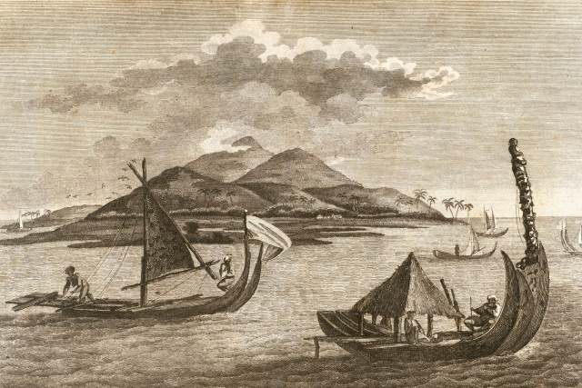
Polynesians Were Pioneers of the Open Ocean

In the early days of ocean navigation, explorers stayed pretty close to the shoreline and used visible landmarks to mark their position. However, Polynesians, the first developers of open ocean exploration, set off from New Guinea and moved eastward in about 1500 BCE. After first traveling to the adjacent Solomon Islands, they gradually journeyed farther and farther east. Their vessel of choice was a double canoe with two hulls connected by crossbeams, kind of like a catamaran.

Venturing out into the open ocean, these explorers eventually reached Fiji, Tonga, Samoa, and Tahiti. They then traveled more than 2,600 miles north to Hawaii — longer than the distance across the U.S. from Portland, Maine, to Seattle, Washington. By roughly 1,000 or possibly 1,200 CE, the descendants of those early explorers populated the entire Polynesian Triangle, the three corners of which are Hawaii, Rapa Nui (aka Easter Island), and New Zealand.

The Polynesians didn’t have any navigational instruments that we know of, so how did they do it? Although their navigation techniques were passed down orally, historians think they navigated using stars, ocean swells, the sun, the moon, and migratory birds. Some Pacific Islanders navigated simply by using the waves themselves. In 1976, a group of Polynesian canoeing enthusiasts made the Tahiti-Hawaii trip using no navigational instruments and a traditional voyaging canoe — a feat that’s since been repeated several times.

Photo credit: Pictures from History/ Universal Images Group via Getty Images

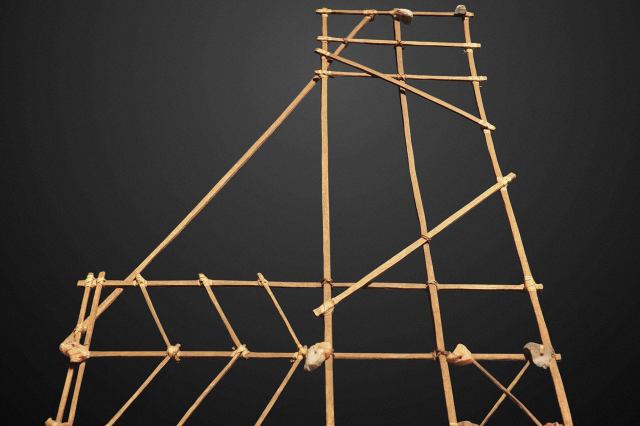
Some Early Nautical Charts Were Made From Shells and Sticks

A nautical chart provides not only topographical information, but also details about the behavior of the sea, such as how tidal patterns interact. Today, we can easily read this data on screens and paper, but ancient Micronesian navigators called ri-metos recorded their knowledge using elaborate “stick charts” made from palm strips, coconut strips, and cowrie shells. 

As you might imagine, these charts weren’t especially portable, so they were designed to be memorized before a voyage. The charts didn’t follow any kind of uniform style, and some of them were only designed to be read by the person who created them, so they can be hard for modern viewers to interpret. We do know, though, that some charts depicted general ocean patterns, while others contained precise piloting instructions.

Photo credit: Universal History Archive/ Universal Images Group via Getty Images

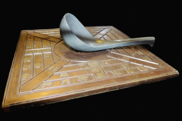
Early Magnetic Compasses Bore Little Resemblance to Their Modern Counterparts

Today, magnetic compasses are so ubiquitous that we just call them “compasses.” They contain a magnetized needle that naturally lines up with the Earth’s magnetic field, so the ends point to magnetic north and magnetic south (moving targets that are  fairly close to true north and true south, but that can lead to errors when traveling very far north or very far south).

Scientists don’t know for sure who made the first compass, but they believe the first compasses to be used for navigation came from 11th- or 12th-century China. The first European usage of a compass was recorded at the end of the 12th century. These early prototypes used lodestones (pieces of naturally-occurring magnetic ore) or needles magnetized with lodestones that were then attached to sticks or corks so they could float in water. 

At first, magnetic compasses were used primarily as backup navigation aids, but as engineers got more savvy, compasses became more reliable. By the 13th century, the compass’s design had graduated to a magnetized needle mounted on a pin at the bottom of a bowl. In time, a directional card with the 32 principal points of direction began to be mounted beneath the needle. The design of the card itself evolved, too: The north point was first marked by a spearhead and a “T” for the Latin word Tramontana, meaning “the north wind.” Around 1490, these symbols were replaced with a fleur-de-lis, which is still commonly seen on compasses today.

Photo credit: Science & Society Picture Library via Getty Images

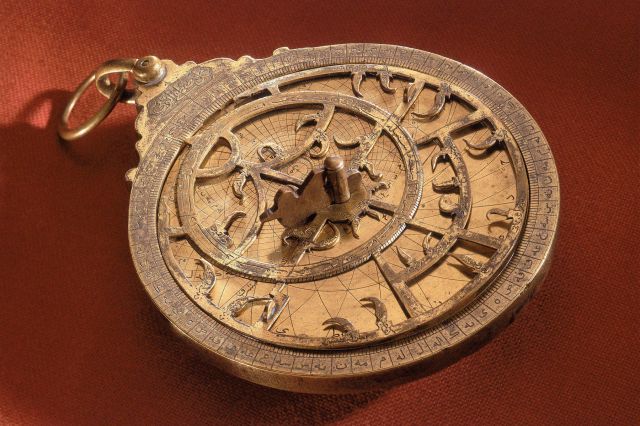
Astrolabes Weren’t Just Used for Navigation

The concept of an astrolabe, a device used to measure the positions of celestial bodies, dates back to ancient Greece in the third or second century BCE — although its exact origin is unclear. By the ninth century CE, astrolabes were highly developed and utilized in Arabic cultures. The devices made their way back to Europe in the 12th century, and the mariner’s astrolabe was a standard piece of navigational equipment by the end of the 15th century, just in time for the Age of Exploration.

Astrolabes are used to determine the locations of celestial bodies relative to the user. A disk called a “mater” holds a series of smaller rotating and sliding disks — one with Earth’s latitude lines and another with well-known constellations and stars. A straight “rule,” or bar, spins around that, and a sight helps determine the altitude of the sun or another star that can then be used as an anchor point. Astrolabes often came with specific plates that corresponded to the different latitudes of certain large cities, because the sky’s geography is affected by one’s latitude.

While these devices were very useful for navigation, it wasn’t their only claim to fame:  In the Islamic world, they helped determine prayer times and the direction of Mecca. During the Middle Ages in Europe, they were consulted to help with decision-making, much like modern horoscopes. And more mundanely, they could also be used for making topographical surveys.

Photo credit: Astrid Harrisson/ Alamy Stock Photo

Vikings May Have Used Crystals to Navigate

The Vikings, a group of seafaring Scandinavian warriors, were also skilled ocean navigators. They began to populate Iceland — around 500 miles from their native Norway — in about 900 CE, even eventually reaching North America. The specifics of their navigation techniques are somewhat mysterious, but recent research indicates they may have used crystals.

Because they sailed their longships in the far North Atlantic, Viking travelers benefitted from up to 24 hours of continuous daylight, but they encountered a lot of fog, too. Ancient Norse literature mentions “sunstones,” stones that helped their holders find the sun — and scientists now think these may have really existed. In 2011, researchers used calcite crystals to pinpoint the location of the sun within 1 degree. It’s not magic, although it sounds like it: Through polarization, crystals can show sunlight patterns that can’t be seen with the naked eye.

Another study from 2014 suggests these crystals may have been used in conjunction with a sun compass. Researchers simulated 3,600 trips between Norway and Greenland at the spring equinox and summer solstice, two dates marked on a disc believed to be a component of a sun compass. They found that by checking the crystals every few hours, the computer-generated voyages successfully reached Greenland 92% of the time.

That study hasn’t been replicated in the real world yet, but it offers some clues to how Viking navigators were able to navigate without the use of magnetic compasses or astrolabes.

Photo credit: Heritage Images/ Hulton Archive via Getty Images

Navigators Knew the Earth Was Round Earlier Than You Might Think

There’s a persistent myth that Christopher Columbus “proved” the Earth was round in the 15th century during his voyage from Europe to the Americas, but he was many centuries too late. In fact, formally educated people knew the world wasn’t flat starting way back in the third century BCE, while scientists and mathematicians may have known as early as the sixth century BCE. Columbus’ surprise landing in the Americas had nothing to do with thinking the Earth was flat — he just thought the global circumference to be smaller than it is and believed he’d end up in Asia. This tenacious myth comes from a highly embellished 1828 biography of Columbus written by Washington Irving, better known for fictional works such as “The Legend of Sleepy Hollow” and “Rip Van Winkle.”

Like the aforementioned scientists and scholars, mariners were aware of the world’s roundness very early on. Sailors observed that when viewing distant ships, the tops of sails and masts were visible before the decks and hulls of the vessels to which they were attached. And as they traveled to different points of the Earth, they also noted being able to see different constellations. Celestial navigation would have been pretty difficult otherwise.

Prevenção a desastres I e II (Sler)

Prevenção a desastres I

Se está evidente que podemos ter novos eventos extremos, o que está sendo feito para capacitar a Defesa Civil e as comunidades vulneráveis?

Artigo original

Sílvia Marcuzzo

16 de agosto de 2024

De 6 a 8 de agosto, aconteceram três lives muito esclarecedoras sobre o que está por trás do antes e depois dos desastres que fomos submetidos no Rio Grande do Sul. Como ainda estamos vivendo o rescaldo de tanta destruição, creio ser muito útil este texto e outros que seguirão nas próximas semanas. Espero que sirva para compreendermos melhor o que estamos atravessando. Se você já se deu conta que precisa acompanhar o que está acontecendo nessa fase de agravamento do aquecimento global, pois isso afeta diretamente o seu cotidiano, inclusive seus planos, o que vou trazer nas próximas linhas será esclarecedor.

Um grupo de jornalistas mulheres, que compõe o Grupo de Trabalho de Comunicação da Rede de Emergência Climática e Ambiental (Reca), organizou em parceria da Federação Nacional de Jornalista (Fenaj) três lives intituladas “Diálogos entre jornalistas e especialistas acerca do desastre”. Dá para acompanhar a gravação no YouTube da Fenaj.

Esses encontros trouxeram muitas coisas que a mídia convencional e as redes sociais não abordaram.

Já parou para pensar o que o jornalismo faz com a ocorrência de desastres e o que os desastres fazem com o jornalismo? Essa foi a indagação da professora Marcia Franz Amaral, da UFSM, na abertura do encontro. Diante do que passamos, com tanta falta de orientação sobre o que fazer, tanto desespero, como deve ser a comunicação com população, com os atingidos, com a imprensa das autoridades e dos detentores de informações técnicas?

Tenho feito a cobertura de desastres, fui diretamente afetada por essa última enchente e venho trabalhando em projetos para despertar o interesse de diferentes públicos sobre as mudanças climáticas. Esse contexto complexo me fez voltar à universidade. Estou fazendo mestrado em comunicação, justamente para pesquisar, desvelar contextos e com aspiração de contribuir para que saibamos encarar com mais assertividade esse momento que exige adaptação e mitigação às mudanças climáticas.

Fui uma das painelistas da primeira live. Foi um mega desafio, pois estava quase sem voz. Peguei uma virose, uma pereba que tem deixado muita gente doente em Porto Alegre e Região Metropolitana. Escrevo isso só para explicar o meu desempenho, se você for me ouvir na live. Eu avalio que também é uma consequência da remexida geral da cidade, na qual o ambiente foi submetido.

E sabem por que fui uma das convidadas a falar? Porque fiz reportagens mostrando contextos em que outros colegas jornalistas não se debruçaram. Fiquei muito tocada com a declaração do Roberto Villar Belmonte, professor da Uniritter, que escreveu em um grupo sobre minha atuação.

“Depois da enchente de 2023, apenas a repórter freelancer Sílvia Marcuzzo fez reportagens de fôlego apontando a falta de governança ambiental (proposital) no RS. A imprensa regional dita hegemônica continua fingindo que o tema não existe, mesmo após maio de 2024. Seria legal citar isso na tua fala, Sílvia, na tua abordagem contínua da pauta, não apenas durante a desgraça (quando a morte é o principal valor notícia)”.

Ele escreveu isso também para justificar a minha participação na programação do 8º Congresso Brasileiro de Jornalismo Ambiental, que esse ano será em Fortaleza. Confere a programação do CBJA, será híbrida, online e presencial.

A primeira live, realizada em 6 de agosto, trouxe a chamada: os alertas foram emitidos. E agora?

Reinaldo Estelles, coordenador-geral do Departamento de Articulação e Gestão, da Secretaria Nacional de Proteção e Defesa Civil do Ministério da Integração e Desenvolvimento Regional, foi categórico: “Não adianta emitir alarmes se a população não souber o que é para fazer”. Esse é um dos pontos nevrálgicos, não basta uma sirene tocar, os bombeiros chamarem. A população precisa compreender o que significa estar em perigo. Creio que quem teve a experiência dos episódios dos meses de maio e junho no Rio Grande do Sul sabe muito bem o que isso quer dizer. Fomos vítimas de uma sequência de trapalhadas, de falta de gestão dos poderes públicos municipais e estadual.

Há muitas dimensões diferentes de informação, que estão intimamente ligadas a vários fatores. Ou seja, mais uma vez ficou supernítido o quanto o Estado que se gaba de “ter façanhas que sirvam de modelo a toda terra” se equivocou em insistir em determinados erros. Há muitas questões por trás das medidas dos tomadores de decisão que precisam ser esclarecidas.

Na live, Estelles anunciou o lançamento do projeto-piloto de um novo sistema de alerta, que aciona todos os celulares de uma região em risco. E reforçou: as Defesas Civis dos municípios e do Estado precisam se capacitar. Outros desastres virão. Ele salientou o quanto as Defesas Civis precisam promover a criação e a mobilização de núcleos comunitários. A participação de vários segmentos, principalmente com a atuação de lideranças locais, são essenciais para a estruturação de planos de contingência. Por favor, se você que me lê souber de algum lugar no Rio Grande do Sul onde isso esteja acontecendo, me conte.

Vagner Anabor, professor de Meteorologia da UFSM, lembrou que o Estado está em uma das regiões de maior incidência de tempestades severas. E na sua opinião, o que vivemos esse ano foi o maior desastre já ocorrido no Brasil. Outra curiosidade apontada por ele é que uns 25% da força de trabalho da Metereologia do País é composta por profissionais formados no RS. Ou seja, o Estado exporta gente qualificada, mas não dispõe de servidores que atuem no próprio território onde nasceram.

Ele defende o fortalecimento de medidas de prevenção. E lamenta que o Climatempo, do governo do Estado, conte apenas com dois metereologistas e um engenheiro hidrólogo. Anabor estima que seria necessária uma equipe entre 20 e 25 pessoas para dar conta de uma área do tamanho do RS.

Outro ponto importante colocado por Anabor é que “a cadeia da informação é muito longa”. E, por questão de minutos, muitas vidas podem ser salvas. Isso quer dizer que, desde o momento em que se sabe o que vem pela frente, até informar e mobilizar diferentes equipes, transmitir alerta e comunicar às comunidades sobre os riscos que eles correm, há muitas etapas a serem cumpridas até o momento de chegar em regiões que serão atingidas. Há diferentes atores envolvidos.

No caso do RS e de Porto Alegre, então, ocorreram muitas situações que deixaram evidente o quanto isso foi prejudicial. E a preparação para lidar com situações de perigo iminente requer planejamento e a execução de um bom plano de contingência (o que também não tivemos por aqui).

Os painelistas salientaram o quanto a imprensa desempenha função crucial para ampliar a percepção de risco da população. Quem cobre precisa saber o que significa uma chuva de 100 milímetros. E para complicar ainda mais o contexto, tem proliferado o número de influencers, gente que só porque sabe falar diante da câmera fica espalhando informações que muitas vezes mais atrapalham do que ajudam. Isso sem falar nas fake news.

Resumindo: enquanto as respectivas autoridades não adotarem condutas responsivas, que assumam o processo de uma comunicação para o bem comum, para salvar vidas, para evitar o pior, teremos que conviver com a insegurança, de procurar entender o que fazer diante de uma situação de risco.

O repórter Luciano Velleda, do Sul21, destacou que diversas vezes a imprensa precisou esperar anúncios da Defesa Civil porque seriam dados pelo governador e pelo prefeito de Porto Alegre em coletivas. Ou seja, assim que chega até a autoridade uma determinada informação, ela é avaliada se é o governador ou o prefeito que serão os porta-vozes. Vale lembrar da vez em que o prefeito sugeriu que os porto-alegrenses deixassem a cidade, fossem para a praia.

Em outros países, onde a comunicação de risco faz parte da cultura e funciona, como o Japão, a cadeia (o caminho que a informação percorre) é curta. Todos são treinados para saber o que fazer em caso de perigo. A autoridade máxima é técnica. Uma série de medidas, como a emissão de alerta em todos os canais de rádio e televisão, são acionadas em caso de risco.

Na próxima semana, trarei mais sobre esse assunto. Porque já está na cara que precisamos avançar nas medidas de prevenção a desastres. Esse assunto não pode e não deve ficar restrito a decisões políticas. A sociedade precisa se apropriar das diversas camadas de conhecimento para evitar danos de toda ordem. Ainda mais em ano de eleição!

Com a palavra, os professores das escolas atingidas pelas enchentes.

Para encerrar, sugiro que vejam a live Inundações no RS e a situação das escolas na RME/POA, realizada no dia 12, onde professores da rede municipal de ensino da Capital contam o que passaram e o que está sendo feito nas escolas atingidas pela enchente. A iniciativa é do projeto de extensão Fazeres Pedagógicos da Faculdade de Educação da UFRGS.

Foto da Capa: Freepik / Gerada por IA
Mais textos de Sílvia Marcuzzo: Clique aqui.

Por Sílvia Marcuzzo – Jornalista e artivista

Sílvia Marcuzzo é jornalista, artivista, mestranda na Famecos/PUCRS e integrante do Grupo de Pesquisa sobre Comunicação, Crise e Cuidado. Articuladora de coletivos, repórter freelancer e editora de publicações socioambientais. Trabalha com comunicação e meio ambiente desde 1993. É consultora e assessora de organizações que atuam pelo bem da coletividade, por um mundo mais sustentável e com qualidade de vida para todos. Saiba mais em silviamarcuzzo.com.br


Prevenção a desastres II

Artigo original

Jornalistas têm muita a dificuldade no acesso às fontes oficiais, o que dificulta muito a imprensa de cumprir o seu papel em momentos de desastre

Sílvia Marcuzzo

23 de agosto de 2024

Seguindo a sequência que comecei a semana passada (clique aqui para ler), hoje abordo o que rolou na live “Diálogos entre jornalistas e especialistas acerca do desastre”, realizada dia 7 de agosto, que pode ser acessada no YouTube da Federação Nacional dos Jornalistas (Fenaj). É o segundo dos três encontros promovidos pelo Grupo de Trabalho de Comunicação da Rede de Emergência Climática e Ambiental (Reca).

Com o tema “O desastre eclodiu. Quais são os protocolos?” Com essa pergunta, a mediadora Débora Gallas, do Grupo de Pesquisa de Jornalismo Ambiental e RECA, conduziu o encontro online que teve a participação de Irineu de Brito Junior, especialista em gestão de desastres da Unesp, Armin Braun, diretor do Centro Nacional de Gerenciamento de Riscos e Desastres (Cenad), e dos jornalistas Maria Teresa Cruz e Paulo Mueller.

Um dos pontos que foi unanimidade entre os debatedores foi a necessidade de se cumprir protocolos. O grande X da questão é que, por aqui, pelos pagos, pela Capital gaúcha, o protocolo é algo nebuloso. Digamos que o protocolo aqui durante a enchente era a Defesa Civil avisar pelos seus canais, incluindo o grupo de WhatsApp, o Instagram e o site oficial, que uma tempestade intensa estava vindo. O governador e o prefeito eram os porta-vozes das informações importantes também.

Armin Braun ressaltou a importância dos jornalistas de veículos para dar a noção sobre a percepção da previsão do tempo. Ele explicou que o Cenad trabalha na preparação e na resposta aos desastres. O foco é justamente articular e capacitar os estados e municípios para encarar os riscos hidrológicos, geológicos, meteorológicos. Há vários órgãos públicos envolvidos nessa rede.

Já o professor Irineu destacou o quanto precisa ser feito um planejamento prévio para que se tenha condições de gerenciar o problema provocado por um desastre. Ele citou variáveis que envolvem a logística para o atendimento às demandas. Tudo isso precisa ser pensado em tempo de calma, antes de uma temporada de tempestades, por exemplo.

E a resposta a situações de calamidade não são apenas com relação a intempéries climáticas. Ele lembrou-se do caso do grande número de venezuelanos entrando em Roraima, que também exigiu uma mobilização do governo. Ou seja, a Defesa Civil dos Estados e municípios precisa estar estruturada, com ações já ensaiadas antes de haver um incidente. Para você que me lê, isso parece óbvio. Mas o que vivemos nesse ano no Rio Grande do Sul demonstrou que pouco ou muito pouco de planos de antecipação, ou de contingência, foi colocado em prática.

Vale lembrar que, só em 2023, ocorreram mortes provocadas por enchentes e enxurradas em março, junho, julho, setembro, novembro e dezembro. Ou seja, já tínhamos tido 81 mortes em distintas regiões do Estado. Esses dados eu mesma levantei junto à Defesa Civil. Mas isso não bastou para que os órgãos competentes tomassem as medidas de precaução em 2024.

O jornalista e radialista Paulo Mueller, que acompanhou vários episódios de acidentes de todo tipo em Santa Catarina, tocou numa situação que todo mundo que cobre esse tipo de pauta enfrenta: a dificuldade de se ter acesso às fontes oficiais. É muito comum os jornalistas pedirem informações para a assessoria de imprensa do governo ou da Defesa Civil, mas se tiver a resposta, a prioridade é o atendimento ao chamado, não a imprensa.

Mueller contou o quanto a Defesa Civil de Santa Catarina se capacitou, se estruturou ao longo do tempo, depois de tantos episódios de enchente. Em Blumenau, por exemplo, todos os moradores já sabem se a sua rua vai alagar. O Estado vizinho também utiliza as escolas para trabalhar a cultura da prevenção. Lá também há muitos problemas devido à ocupação desordenada no solo.

E aí, pergunto: por que ainda não se estruturou programas de educação e comunicação que atendam às necessidades das comunidades e da imprensa? Será que os governos estão se dando conta que se houvesse um sistema eficiente que explicasse o risco, nesse momento de crise climática, as mortes e perdas incalculáveis seriam evitadas? Isso é ou não é negacionismo?

Essas lives são muito esclarecedoras para termos noção do quanto esse assunto precisa ser compreendido por todos. Pois somos todos vulneráveis a novos possíveis episódios. Pior: situações terríveis de desgraça ainda são usadas politicamente para contar vantagem de que estão fazendo isso, aquilo, quando, na verdade, para evitar que o pior acontecesse, quase nada foi feito. Assim que um técnico fica sabendo o risco que determinada região, município corre, o tomador de decisão é informado. Só que o que sentimos na pele, aqui no RS, é que a decisão de informar e como informar é muito lenta ou considera primeiro o contexto político e não o socioambiental e econômico.

Em tempos de redes sociais e de “influencers” que se aproveitam de tragédias para ter mais visualizações, muita mentira, desinformação da pior espécie circulou. Então, é mais do que na hora dos governos estruturarem mecanismos de comunicação que traduzam e deixem claro o que deve ser feito em caso de risco. Será que não seria mais eficiente do que ter que desmentir as mentiras que espalham durante os desastres?

Segundo Maria Teresa, que acompanhou de perto o desastre de São Sebastião, no carnaval do ano passado, as autoridades de São Paulo sabiam que choveria muito acima da média naquele feriadão, mas não se empenharam em alertar sobre o risco que as pessoas correriam ao ir para o badalado litoral paulista. Ela disse ainda que o Instituto de Pesquisas Tecnológicas (IPT) já tinha feito um levantamento e mapeado 52 áreas de risco – mais da metade no lugar onde houve o deslizamento – em São Sebastião. Será que o governo não tomou as medidas de prevenção necessárias para salvar vidas?

A jornalista reforçou a necessidade de os profissionais de imprensa saberem se cuidar e obedecerem aos protocolos de seguranças. Ela atualmente atua em favelas no Rio e diz que as medidas são iguais à cobertura de um campo minado de guerra. Maria Teresa salientou a necessidade das redações, de quem atua direto nas coberturas, se capacitarem para enfrentar desafios extremos. Ficar sem conexão de celular, sem conseguir chegar aos locais e, ao mesmo tempo, ter empatia para saber se colocar no lugar do outro, são desafios complexos que precisam ser pensados muito antes de um desastre acontecer.

Você sabe doar direito?

A comunicação sobre o que doar e formas de como enviar também foram abordadas no encontro. Os participantes evidenciaram o quanto a população precisa ser solidária na hora de escolher e remeter as doações. Tem gente que mandou fantasia de carnaval, roupas íntimas – aliás, não se deve mandar esse tipo de vestimenta usada, só se for nova – pinguim de geladeira e até fita VHS de como fazer bijuterias para abrigos. Outra dica é que pares de sapatos devem estar amarrados juntos, pois também é fácil de se perder um pé do outro.

Situação das escolas

Marque na agenda, haverá outra live sobre a situação hoje das escolas atingidas pela enchente. Já foram realizados encontros online nos dias 22 de julho e 12 de agosto, com as escolas da Rede Municipal de Ensino de POA. A próxima será no dia 2 de setembro, às 19h30. Os professores estarão tratando das escolas públicas de Região Metropolitana. No YouTube do projeto Fazeres Pedagógicos, um projeto da Faculdade de Educação da UFRGS.

Foto da Capa: Freepik
Mais textos de Sílvia Marcuzzo: Clique Aqui.

Por Sílvia Marcuzzo – Jornalista e artivista

Sílvia Marcuzzo é jornalista, artivista, mestranda na Famecos/PUCRS e integrante do Grupo de Pesquisa sobre Comunicação, Crise e Cuidado. Articuladora de coletivos, repórter freelancer e editora de publicações socioambientais. Trabalha com comunicação e meio ambiente desde 1993. É consultora e assessora de organizações que atuam pelo bem da coletividade, por um mundo mais sustentável e com qualidade de vida para todos. Saiba mais em silviamarcuzzo.com.br

Extreme weather 101: Your guide to staying prepared and informed (Grist)

Original article

How to pack a go-bag, get emergency alerts, and find disaster aid.

Chandan Khanna/AFP via Getty Images

Lyndsey Gilpin & Jake Bittle

PublishedAug 20, 2024

This guide is part of State of Emergency, a Grist series exploring how climate disasters are impacting voting and politics. A companion piece examines the logistics of voting if you’ve been impacted by extreme weather.

No matter where you live, extreme weather can hit your area, causing damage to homes, power outages, and dangerous or deadly conditions. If you’re on the coast, it may be a hurricane; in the Midwest or South, a tornado; in the West, wildfires; and as we’ve seen in recent years, anywhere can experience heat waves or flash flooding

Living through a disaster and its aftermath can be both traumatic and chaotic, from the immediate losses of life and belongings to conflicting information around where to access aid. The weeks and months after may be even more difficult, as the attention on your community is gone but civic services and events have stalled or changed drastically. 

Grist compiled this resource guide to help you stay prepared and informed. It looks at everything from how to find the most accurate forecasts to signing up for emergency alerts to the roles that different agencies play in disaster aid. 

An aerial view shows flooding in Merced, California following a “bomb cyclone” in January 2023. Josh Edelson / AFP via Getty Images

Where to find the facts on disasters 

These days, many people find out about disasters in their area via social media. But it’s important to make sure the information you’re receiving is accurate. Here’s where to find the facts on extreme weather and the most reliable places to check for emergency alerts and updates.

Your local emergency manager:  Your city or county will have an emergency management department, which is part of the local government. In larger cities, it’s often a separate agency; in smaller communities, fire chiefs or sheriff’s offices may manage emergency response and alerts. Emergency managers are responsible for communicating with the public about disasters, managing rescue and response efforts, and coordinating between different agencies. They usually have an SMS-based emergency alert system, so sign up for those via your local website (Note: Some cities have multiple languages available, but most emergency alerts are only in English.) Many emergency management agencies are active on Facebook, so check there for updates as well. 

Local news: The local television news and social media accounts from verified news sources will have live updates during and after a storm. Follow your local newspaper and television station on Facebook or other social media, or check their websites regularly. 

Weather stations and apps: The Weather Channel, Apple Weather, and Google will have information on major storms, but that may not be the case for smaller-scale weather events, and you shouldn’t rely on these apps to tell you if you need to evacuate or move to higher ground. 

National Weather Service: This agency, also known as NWS, is part of the National Oceanic and Atmospheric Administration and offers information and updates on everything from wildfires to hurricanes to air quality. You can enter your zip code on weather.gov and customize your homepage. The NWS also has regional and local branches where you can sign up for SMS alerts. If you’re in a rural area or somewhere that isn’t highlighted on its maps, keep an eye out for local alerts and evacuation orders, as NWS may not have as much information ahead of time.  

Cal Fire firefighters livestream images and data from efforts to control and contain the Park Fire on July 29 near Chico, California. David McNew/Getty Images

How to pack an emergency kit

As you prepare for a storm, it’s important to have an emergency kit ready in case you lose power or need to leave your home. Review this checklist from the Federal Emergency Management Agency, or FEMA, for what to pack so you can stay safe, hydrated, and healthy. 

These can often be expensive to create, so contact your local disaster aid organizations, houses of worship, or charities to see if there are free or affordable kits available. Try to gather as much as you can ahead of time in case shelves are empty when a storm is on the way.

Some of the most important things to have:

  • Water (one gallon per person per day for several days)
  • Food (at least a several-day supply of non-perishable food) and a can opener
  • Medicines and documentation of your medical needs
  • Identification and proof of residency documents (see a more detailed list below)
  • Battery-powered or hand crank radio, batteries, flashlight
  • First aid kit
  • Masks, hand sanitizer, and trash bags 
  • Wrench or pliers 
  • Cell phone with chargers and a backup battery
  • Diapers, wipes, and food or formula for babies and children
  • Food and medicines for any household pets

Don’t forget: Documents

One of the most important things to have in your emergency kit is documents you may need to prove your residence, demonstrate extent of damage, and vote. FEMA often requires you to provide these documents in order to receive financial assistance after a disaster.

  • Government issued ID, such as a drivers’ license for for each member of your household
  • Proof of citizenship or legal residency for each member of your household (passport, green card, etc.)
  • Social Security card for each member of your household
  • Documentation of your medical needs, such as medications or special equipment including oxygen tanks, wheelchairs, etc.
  • Health insurance card
  • Car title and registration documents
  • Pre-disaster photos of the inside and outside of your house and belongings
  • Copy of your homeowners’ or renters’ insurance policy
  • For homeowners: copies of your deed, mortgage information, and flood insurance policy, if applicable
  • For renters: a copy of your lease
  • Financial documents such as a checkbook or voided check

You can find more details about why you may need these documents here.

A volunteer assesses the remains of a charred apartment complex in the aftermath of a wildfire in Lahaina, western Maui, Hawaiʻi in 2023.
Yuki Iwamura/AFP via Getty Images

Disaster aid 101

It can be hard to know who to lean on or trust when it comes to natural disasters. Where do official evacuation orders come from, for example, or who do you call if you need to be rescued? And where can you get money to help pay for emergency housing or to rebuild your home or community. Here’s a breakdown of the government officials and agencies in charge of delivering aid before, during, and after a disaster:

Emergency management agencies: Almost all cities and counties have local emergency management departments, which are part of the local government. Sometimes they’re agencies all their own, but in smaller communities, fire chiefs or sheriff’s offices may manage emergency response and alerts. These departments are the first line of defense during a weather disaster. They’re responsible for communicating with the public about incoming disasters, managing rescue and response efforts during an extreme weather event, and coordinating between different agencies. Many emergency management agencies, however, have a small staff and are under-resourced.

Much of the work that emergency managers do happens before a disaster: They develop response plans that lay out evacuation routes and communication procedures, and they also delegate responsibility to different government agencies like the police, fire, and public health departments. Most counties and cities publish these plans online. 

In most cases, they are the most trustworthy resource in the days just before and just after a hurricane or other big weather event. They’ll send out alerts and warnings, coordinate evacuation efforts, and direct survivors and victims to resources and shelter.

You can find your state emergency management agency here. There isn’t a comprehensive list by county or city, but if you search your location online you’ll likely find a website, a page on the county or city website, or a Facebook page that posts updates. 

Law enforcement: County sheriffs and city police departments are often the largest and best-staffed agencies in a given community, so they play a key role during disasters. Sheriff’s departments often enforce mandatory evacuation orders, going door-to-door to ensure that people vacate an area. They manage traffic flow during evacuations and help conduct search and rescue operations. 

Law enforcement agencies may restrict access to disaster areas for the first few days after a flood or fire. In most states, city and county governments also have the power to issue curfew orders, and law enforcement officers can enforce these curfews with fines or even arrests. In some rural counties, the sheriff’s department may serve as the emergency management department. 

Lexington Firefighters’ swift water teams rescue people stranded by extreme rain in Lost Creek, Kentucky in 2022. Michael Swensen/Getty Images

Governor: State governors control several key aspects of disaster response. They have the power to declare a state of emergency, which allows them to deploy rescue and repair workers, distribute financial assistance to local governments, and activate the state National Guard. The governor has a key role in the immediate response to a disaster, but a smaller role in distributing aid and assistance to individual disaster victims.

In almost all U.S. states, and all hurricane-prone states along the Gulf of Mexico, the governor also has the power to announce mandatory evacuation orders. The penalty for not following these orders differs, but is most often a cash fine. (Though states seldom enforce these penalties.) The state government also decides whether to implement other transportation procedures such as contraflow, where officials reverse traffic flow on one side of a highway to allow larger amounts of people to evacuate. 

HUD: The Department of Housing and Urban Development, or HUD, also spends billions of dollars to help communities recover after disasters, building new housing and public buildings such as schools — but this money takes much longer to arrive. Unlike FEMA, HUD must wait for Congress to approve its post-disaster work, and then it must dole out grants to states for specific projects. In some cases, such as the aftermaths of Hurricane Laura in Louisiana or Hurricane Florence in North Carolina, it took years for projects to get off the ground. States and local governments, not individual people, apply for money from HUD, but the agency can direct you to FEMA or housing counselors.

A homeowner hangs a sign that reads “FEMA please help make Mexico Beach great again” on a house damaged by Hurricane Michael in Florida in 2018. Hector Retamal/AFP via Getty Images

FEMA

The Federal Emergency Management Agency, or FEMA, is the federal government’s main disaster response agency. It provides assistance to states and local governments during large events like hurricanes, wildfires, and floods. FEMA is part of the Department of Homeland Security.

FEMA is almost never the first resource on the ground after a disaster strikes. In order for the agency to send resources to a disaster area, the state’s governor must first request a disaster declaration from the president, and the president must approve it. For large disasters such as Category 4 or 5 hurricanes, this typically happens fast. For smaller disasters, like severe rain or flooding events, it can take weeks or even months for the president to grant a declaration and activate the agency. FEMA has historically not responded to heat waves.

FEMA is broken into regional offices and offers specific contacts and information for each of those, as well as for tribal nations. You can find your FEMA region here.

FEMA has two primary roles after a federally declared disaster:

Contributing to community rebuilding costs: The agency helps states and local governments pay for the cost of removing debris and rebuilding public infrastructure. During only the most extreme events, the agency also deploys its own teams of firefighters and rescue workers to help locate missing people, clear roadways, and restore public services. For the most part, states and local law enforcement conduct on-the-ground recovery work. (Read more about FEMA’s responsibilities and programs here.)

Individual financial assistance: FEMA gives out financial assistance to individual people who have lost their homes and belongings. This assistance can take several forms. FEMA gives out pre-loaded debit cards to help people buy food and fuel in the first days after a disaster, and may also provide cash payments for home repairs that your insurance doesn’t cover. The agency also provides up to 18 months of housing assistance for people who lose their homes in a disaster, and sometimes houses disaster survivors in its own manufactured housing units or “FEMA trailers.” FEMA also sometimes covers funeral and grieving expenses as well as medical and dental treatment.

In the aftermath of a disaster, FEMA offers survivors:

  • A one-time payment of $750 for emergency needs
  • Temporary housing assistance equivalent to 14 nights’ stay in a hotel in your area 
  • Up to 18 months of rental assistance
  • Payments for lost property that isn’t covered by your homeowner’s insurance
  • And other forms of assistance, depending on your needs and losses

If you are a U.S. citizen or meet certain qualifications as a non-citizen and live in a federal disaster declaration area, you are eligible for financial assistance. Regardless of citizenship or immigration status, if you are affected by a disaster you may be eligible for crisis counseling, disaster legal services, disaster case management, medical care, shelter, food, and water. 

FEMA representatives take information from people displaced by Hurricane Ian in Estero, Florida in 2022. Thomas Simonetti for The Washington Post via Getty Images

FEMA also runs the National Flood Insurance Program, which provides insurance coverage of up to $350,000 for home flood damage. The agency recommends that everyone who lives in a flood zone purchase this coverage — and most mortgage lenders require it for borrowers in flood zones — though many homes outside the zones are also vulnerable. You must begin paying for flood insurance at least 30 days before a disaster in order to be eligible for a payout. You can check if your home is in a flood zone by using this FEMA website.

How to get FEMA aid: The easiest way to apply for individual assistance from FEMA is to fill out the application form on disasterassistance.gov. This is easiest to do from a personal computer over Wi-Fi, but you can do it from a smartphone with cellular data if necessary. This website does not become active until the president issues a disaster declaration.

Some important things to know:

  • FEMA will require you to create an account on the secure website Login.gov. Use this account to submit your aid application. 
  • You can track the status of your aid application and receive notifications if FEMA needs more documents from you. 
  • If FEMA denies your application for aid, you can appeal, but the process is lengthy. 

Visiting a FEMA site in your area after a disaster: FEMA disaster recovery centers are facilities and mobile units where you can find information about the agency’s programs as well as other state and local resources. FEMA representatives can help you navigate the aid application process or direct you to nonprofits, shelters, or state and local resources. Visit this website to locate a recovery center in your area or text DRC and a ZIP Code to 43362. Example: DRC 01234.  

A woman looks over her apartment in Fort Myers, Florida, after Hurricane Ian inundated it with floodwaters in 2022. Joe Raedle/Getty Images

What to expect after a disaster

Disasters affect people in many different ways, and it’s normal to grieve your losses — personal, professional, community — in your own time. Here are a few resources if you need mental health support after experiencing an extreme weather event.

  • The National Center for PTSD, or post-traumatic stress disorder, on what to expect after experiencing a disaster.
  • The American Red Cross has disaster mental health volunteers they often dispatch to areas hit by a disaster.
  • The Substance Abuse and Mental Health Services Administration, or SAMHSA, has a fact sheet on managing stress after a disaster. The agency has a Disaster Distress Helpline that provides 24/7 crisis counseling and support. Call or text: 1-800-985-5990

After a disaster is an especially vulnerable time. Beware of scams and make sure to know your rights. 

  • Be wary of solicitors who arrive at your home after a disaster claiming to represent FEMA or another agency. FEMA will never ask you for money. The safest way to apply for aid is through FEMA’s official website: disasterassistance.gov
  • Be cautious about hiring contractors or construction workers in the days after a disaster. Many cities require permits for rebuilding work, and it’s common for scammers to pose as contractors after a disaster. 
  • Renters can often face evictions after a disaster, so familiarize yourself with tenant rights in your state. 
Residents of Paradise, California visit the town’s planning department to file permitting applications to re-build homes and other structures after the devastating 2018 Camp Fire. Gabrielle Lurie/San Francisco Chronicle via Getty Image

What to keep in mind before, during, and after a disaster

The most important thing to consider during a disaster is your own, your family’s, and your community’s safety. The National Weather Service has a guide for hurricanes and floods; FEMA has a guide for wildfires; the Centers for Disease Control and Prevention has a guide for extreme heat safety.

A few potentially life-saving things to remember:

  • Never wade in floodwaters. They often contain harmful runoff from sewer systems and can cause serious illness and health issues.
  • If it’s safe to do so, turn off electricity at the main breaker or fuse box in your home or business before a hurricane to prevent electric shock. 
  • If you lose power, never operate a generator inside your home. Generators emit carbon monoxide, a colorless and odorless gas that can be fatal if inhaled.

Did we miss something? Please let us know by emailing community@grist.org.

Confessions of a Theoretical Physicist (Nautilus)

My life among the elementary particles has made me question whether reality exists at all.

By Vijay Balasubramanian

August 19, 2024

Iremember the day when, at the age of 7, I realized that I wanted to figure out how reality worked. My mother and father had just taken us shopping at a market in Calcutta. On the way back home, we passed through a dimly lit arcade where a sidewalk bookseller was displaying his collection of slim volumes. I spotted an enigmatic cover with a man looking through a microscope; the words “Famous Scientists” were emblazoned on it, and when I asked my parents to get it for me, they agreed. As I read the chapters, I learned about discoveries by Antonie van Leeuwenhoek of the world of microscopic life, by Marie Curie about radioactivity, by Albert Einstein about relativity, and I thought, “My God, I could do this, too!” By the time I was 8, I was convinced that everything could be explained, and that I, personally, was going to do it.

Decades have passed, and I am now a theoretical physicist. My job is to work out how all of reality works, and I take that mission seriously, working on subjects ranging from the quantum theory of gravity to theoretical neuroscience. But I must confess to an increasing sense of uncertainty, even bafflement. I am no longer sure that working out what is “real” is possible, or that the reality that my 7-year-old self conceived of even exists, rather than being simply unknown. Perhaps reality is genuinely unknowable: Things exist and there is a truth about them, but we have no way of finding it out. Or perhaps the things we call “real” are called into being by their descriptions but do not independently exist.

The theories and concepts we build are like ladders we use to reach the truth.

I am steeped in the cultural traditions of physics, a field that is my calling and trade, and in the philosophies of India with which I was raised. As a physicist, I remain committed to a system of thought which posits that: (1) things we observe are definitely real, (2) the details may be unknown, (3) bounded resources may slow progress, but (4) physical inquiry can lead us to the real truth, as long as we have time and proceed with patience. On the other hand, I am also acutely aware of philosophical traditions to the effect that: (1) there may be a reality, but (2) measurements from the world are inherently misleading and partial, so that (3) the real may be formally indescribable, and that (4) we may not have a systematic way to reach the fundamentally real and true.

The idea that the real may be unknowable is very old. Consider the creation hymn in the Rig Veda, composed around 1500 to 1000 B.C., called the “Nasadiya Sukta.” This verse addresses fundamental questions of cosmology and the origin of the universe. In a beautiful translation by Juan Mascaró, it asks: 

Who knows the truth? Who can tell whence and how arose this universe? The gods are later than its beginning: Who therefore knows whence comes this creation? Only he who sees in the highest heaven: He only knows whence came this universe and whether it was made or un-created. He only knows, or perhaps he knows not.

The poet who wrote this verse points out the fundamental problem of epistemology: We don’t know some things and may not even have any way of determining what we don’t know. Some questions may be intrinsically unanswerable. Or the answers may be contradictory. The “Isha Upanishad,” a Sanskrit text from the first millennium B.C., attempts to describe a reality that escapes common sense: “It moves and it moves not, it is far and it is near, it is inside and it is outside.”

A second problem is that perception fundamentally limits our ability to apprehend reality. A prosaic example is the perception of color. Eagles, turtles, bees, and shrimp sense more and different colors than we humans do; in effect, they see different worlds. Different perceptual realities can create different cognitive or conceptual realities.

Jorge Luis Borges pushed this idea to the limit in his story “Funes the Memorious,” about a man who acquires a sort of infinite perceptual capacity. Borges writes: “A circle drawn on a blackboard, a right triangle … are forms that we can fully grasp; … [Funes] could do the same with the stormy mane of a pony … with the changing fire and its innumerable ashes.” Funes’ superpower sounds wondrous, but there is a catch. Borges writes that Funes was “almost incapable of ideas of a general, Platonic sort. Not only was it difficult for him to comprehend that the generic symbol dog embraces so many unlike individuals of diverse size and form; it bothered him that the dog … (seen from the side) should have the same name as the dog … (seen from the front).” The precision of Funes’ perception of reality prevents him from thinking in the coarse-grained categories that we associate with thought and cognition—categories which, necessarily rough, texture our imagined reality.

The arbitrariness of categories was the subject of another Borges story, “The Analytical Language of John Wilkins,” in which Wilkins imagined dividing animals into those belonging to the Emperor, those that are crazy-acting, those painted with the finest brush made of camel hair, those which have just broken a vase, those that from a long way off look like flies, and other oddly specific groupings.

In Body Image
SKETCHY: Students and the public are often told the world consists of real particles called quarks and leptons. Yet these are only concepts that approximate a certain sketch of the structure of the world. Image by Fouad A. Saad / Shutterstock.

The philosopher Michel Foucault, in his book The Order of Things, drew inspiration from Borges’ stories to reflect on the nature of categorization. He suggested that the categories and concepts that we define control our bounded cognition and, in their intrinsic arbitrariness, structure the realities that reside in our minds.

Foucault’s analysis resonates with me because it reminds me of categories in physics. For example, we routinely tell our students and the public that the world consists of particles called quarks and leptons, along with subatomic force fields. Yet these are concepts that reify a certain approximate sketch of the structure of the world. Physicists once thought that these categories were fundamental and real, but we now understand them as necessarily inexact because they ignore the finer details that our instruments have just not been able to measure.

If our categories determine the reality we perceive, can having an idea call a reality into being? This question is a version of the “simulation hypothesis,” whereby all of reality as we know it is simply a simulation in some computational engine, or perhaps a version of the idealism of Plato, where things that we can conceive in the world echo imperfectly an ideal that is the true reality.

Consider, for example, Mymosh the Self-begotten, the tragic hero of a story by Polish writer, Stanislaw Lem, in his volume The Cyberiad. Mymosh, a sentient machine self-organized by accident from a cosmic garbage heap, conjures up entire worlds and peoples just by imagining them. Are those people real, or are they all in his head? In fact, is there a difference? After all, Mymosh’s imagination is a physical process—electrical impulses in his brain. So perhaps the people he imagines are real in some sense.

Things exist and there is a truth about them, but we have no way of finding it out.

Some of these philosophical conundrums have concrete avatars in theoretical physics. Consider the notion of “duality” between physical theories. In this context, a “theory” means a mathematical description of a hypothetical universe, which we develop as a stepping-stone to understanding the actual universe in which we live. Two theories are said to be “dual,” or equivalent, if every observable in one matches some observable in the other. In other words, the two theories are different representations of the same physical system. Often in these dualities the elementary variables, or particles, of one theory become the collective variables, or lumps of particles, of the other, and vice versa. Dual theories scramble some of the most basic categories in physics, such as the difference between “bosonic” particles (any number of which can be in the same place at the same time) and “fermionic” particles (no two of which can be in the same place at the same time). These two kinds of particles have entirely different physical properties, so you would think that they could not be equivalent. But through dualities, it turns out that lumps of bosons can act like fermions, and vice versa. So, what’s the reality here?

Even more dramatic are dualities involving the force of gravity. On one side, we have theories of matter and all the forces except gravity; on the other, we have theories of matter and forces including gravity. These theories look very different. They are couched in terms of different forms of matter, different types of forces, and even different numbers of spacetime dimensions. Yet they describe precisely the same fundamental physics. So, what is “real” here? If one theory says the force of gravity operates and the other says it doesn’t, what do we conclude about the reality of gravity? Perhaps we can use my sketch to visualize the situation—we are able to tell stories about the corners of this diagram of possible worlds, where simplifications and approximations suffice, but the categories and concepts that we have been capable of, at least to date, fail to describe the interior where reality is actually located.

In Body Image
Sketch by Vijay Balasubramanian

Quantum mechanics makes things even more confusing. Quantum-mechanical states of a system can be combined, or superposed, in seemingly contradictory ways. So, the spin of an electron can be in a superposition of pointing up and down—an idea that might seem akin to suggesting that, say, a cat can be in a superposition of alive and dead. Does that mean these objects are in both states or neither state? Some theories suggest that measuring a cat (to continue with this metaphor) could cause it to collapse into a state of aliveness or deadness; others, evoking something like the many-worlds theory, suggest that the combined superposition continues through time. This is a casse-tête, a head breaker.

Where does this leave me? Perhaps we can reconcile all these ideas by following Ludwig Wittgenstein, who proposed in his Tractatus Logico-Philosophicus, possibly referencing previous ideas of Søren Kierkegaard, that the theories and concepts we build are like ladders or nets we use to reach the truth, but we must throw them away upon getting there. I myself am trying to find my way by working in multiple fields, both physics and neuroscience, studying both the world and the mind that perceives it, because I believe that the quest to understand the reality of the universe must contend with the truncations imposed by the perceptual and cognitive limitations of the mind.

Should we bother seeking truths about the world in light of the doubts I have set out? I am hardly the first to ask. Socrates, according to Plato, remarked to Meno: “I would contend … that we will be better [people], braver and less idle, if we believe that one must search for the things one does not know, rather than if we believe that it is not possible to find out what we do not know and that we must not look for it.”

I am with Socrates on this one—his attitude is wise and pragmatic. If there is a reality and a truth about it, we will be better off and more likely to find it by searching, rather than assuming that it is not there. And even if the search, and the ladders we use to climb obstacles, do not lead us to the truth, we will enjoy the journey.  

Lead image by Tasnuva Elahi; with photos by Vijay Balasubramanian

Andrew Ng’s new model lets you play around with solar geoengineering to see what would happen (MIT Technology Review)

technologyreview.com

The climate emulator invites you to explore the controversial climate intervention. I gave it a whirl.

August 23, 2024

James Temple


AI pioneer Andrew Ng has released a simple online tool that allows anyone to tinker with the dials of a solar geoengineering model, exploring what might happen if nations attempt to counteract climate change by spraying reflective particles into the atmosphere.

The concept of solar geoengineering was born from the realization that the planet has cooled in the months following massive volcanic eruptions, including one that occurred in 1991, when Mt. Pinatubo blasted some 20 million tons of sulfur dioxide into the stratosphere. But critics fear that deliberately releasing such materials could harm certain regions of the world, discourage efforts to cut greenhouse-gas emissions, or spark conflicts between nations, among other counterproductive consequences.

The goal of Ng’s emulator, called Planet Parasol, is to invite more people to think about solar geoengineering, explore the potential trade-offs involved in such interventions, and use the results to discuss and debate our options for climate action. The tool, developed in partnership with researchers at Cornell, the University of California, San Diego, and other institutions, also highlights how AI could help advance our understanding of solar geoengineering. 

The current version is bare-bones. It allows users to select different emissions scenarios and various quantities of particles that would be released each year, from 25% of a Pinatubo eruption to 125%. 

Planet Parasol then displays a pair of diverging lines that represent warming levels globally through 2100. One shows the steady rise in temperatures that would occur without solar geoengineering, and the other indicates how much warming could be reduced under your selected scenario. The model can also highlight regional temperature differences on heat maps.

You can also scribble your own rising, falling, or squiggling line representing different levels of intervention across the decades to see what might happen as reflective aerosols are released.

I tried to simulate what’s known as the “termination shock” scenario, exploring how much temperatures would rise if, for some reason, the world had to suddenly halt or cut back on solar geoengineering after using it at high levels. The sudden surge of warming that could occur afterward is often cited as a risk of geoengineering. The model projects that global temperatures would quickly rise over the following years, though they might take several decades to fully rebound to the curve they would have been on if the nations in this simulation hadn’t conducted such an intervention in the first place. 

To be clear, this is an exaggerated scenario, in which I maxed out the warming and the geoengineering. No one is proposing anything like this. I was playing around to see what would happen because, well, that’s what an emulator lets you do.

You can give it a try yourself here

Emulators are effectively stripped-down climate models. They’re not as precise, since they don’t simulate as many of the planet’s complex, interconnected processes. But they don’t require nearly as much time and computing power to run.

International negotiators and policymakers often use climate emulators, like En-ROADS, to get a quick, rough sense of the impact that potential rules or commitments on greenhouse-gas emissions could have. 

The Parasol team wanted to develop a similar tool specifically to allow people to evaluate the potential effects of various solar geoengineering scenarios, says Daniele Visioni, a climate scientist focused on solar geoengineering at Cornell, who contributed to Planet Parasol (as well as an earlier emulator).

Climate models are steadily becoming more powerful, simulating more Earth system processes at higher resolutions, and spitting out more and more information as they do. AI is well suited to help draw meaning and understanding from that data. It’s getting ever better at spotting patterns within huge data sets and predicting outcomes based on them.

Ng’s machine-learning group at Stanford has applied AI to a growing list of climate-related subjects. Among other projects, it has developed tools to identify sources of methane emissions, recognize the drivers of deforestation, and forecast the availability of solar energy. Ng also helps oversee the AI for Climate Change bootcamp at the university.

But he says he’s been spending more and more of his time exploring the potential of solar geoengineering (sometimes referred to as solar radiation management, or SRM), given the threat of climate change and the role that AI can play in advancing the research field. 

There are “many things one can do—and that society broadly should work on—to help address climate change, first and foremost decarbonization,” he wrote in an email. “And SRM is where I’m focusing most of my climate-related efforts right now, given that this is one of the places where engineers and researchers can make a big difference (in addition to decarbonization).”

In a 2022 piece, Ng noted that AI could play several important roles in geoengineering research, including “autonomously piloting high-altitude drones” that would disperse reflective particles, modeling effects of geoengineering across specific regions, and optimizing techniques. 

Planet Parasol itself is built on top of another climate emulator, developed by researchers at the University of Leeds and the University of Oxford, that relies on the rules of physics to project global average temperatures under various scenarios. Ng’s team then harnessed machine learning to estimate the local cooling effects that could result from varying levels of solar geoengineering, says Jeremy Irvin, a grad student in his research group at Stanford.

One of the clearest limits of the current version of the tool, however, is that the results look dazzling. In the scenarios I tested, solar geoengineering cleanly cuts off the predicted rise in temperatures over the coming decades, which it may well do. 

That might lead the casual user of such a tool to conclude: Cool, let’s do it!

But even if solar geoengineering does help the world on average, it could still have negative effects, such as harming the protective ozone layer, disturbing regional rainfall patterns, undermining agriculture productivity, and changing the distribution of infectious diseases. 

None of that is incorporated in the results as yet. Plus, a climate emulator isn’t equipped to address deeply complex societal concerns. For instance, does researching such possibilities ease pressure to address the root causes of climate change? Can a tool that works at the scale of the planet ever be managed in a globally equitable way? Planet Parasol won’t be able to answer either of those questions.

Holly Buck, an environmental social scientist at the University at Buffalo and author of After Geoengineering, questioned the broader value of such a tool along similar lines.

In focus groups that she has conducted on the topic of solar geoengineering, she’s found that people easily grok the concept that it can curb warming, even without seeing the results plotted out in a model.

“They want to hear about what can go wrong, the impact on precipitation and extreme weather, who will control it, what it means existentially to fail to deal with the root of the problem, and so on,” she said in an email. “So it is hard to imagine who would actually use this and how.”

Visioni explained that the group did make a point of highlighting major challenges and concerns at the top of the page. He added that they intend to improve the tool over time in ways that will provide a fuller sense of the uncertainties, trade-offs, and regional impacts.

“This is hard, and I struggled a lot with your same observation,” Visioni wrote in an email. “But at the same time … I came to the conclusion it’s worth putting something down and work[ing] to improve it with user feedback, rather than wait until we have the perfect, nuanced version.”

As to the value of the tool, Irvin added that seeing the temperature reduction laid out clearly can make a “stronger, lasting impression.” 

“We are calling for more research to push the science forward about other areas of concern prior to potential implementation, and we hope the tool helps people understand the capabilities of SAI and support future research on it,” he said.

One-quarter of unresponsive people with brain injuries are conscious (Nature)

More people than we thought who are in comas or similar states can hear what is happening around them, a study shows.

14 August 2024

Julian Nowogrodzki

    A coloured CT scan showing a bleed on a patient's brain.
    Blood (red; artificially coloured) pools in the brain of a person who has had a stroke, a common cause of coma.Credit: Zephyr/Science Photo Library

    At least one-quarter of people who have severe brain injuries and cannot respond physically to commands are actually conscious, according to the first international study of its kind1.

    Although these people could not, say, give a thumbs-up when prompted, they nevertheless repeatedly showed brain activity when asked to imagine themselves moving or exercising.

    “This is one of the very big landmark studies” in the field of coma and other consciousness disorders, says Daniel Kondziella, a neurologist at Rigshospitalet, the teaching hospital for Copenhagen University.

    The results mean that a substantial number of people with brain injuries who seem unresponsive can hear things going on around them and might even be able to use brain–computer interfaces (BCIs) to communicate, says study leader Nicholas Schiff, a neurologist at Weill Cornell Medicine in New York City. BCIs are devices implanted into a person’s head that capture brain activity, decode it and translate it into commands that can, for instance, move a computer cursor. “We should be allocating resources to go out and find these people and help them,” Schiff says. The work was published today in The New England Journal of Medicine1.

    Scanning the brain

    The study included 353 people with brain injuries caused by events such as physical trauma, heart attacks or strokes. Of these, 241 could not react to any of a battery of standard bedside tests for responsiveness, including one that asks for a thumbs-up; the other 112 could.

    Everyone enrolled in the study underwent one or both of two types of brain scan. The first was functional magnetic resonance imaging (fMRI), which measures mental activity indirectly by detecting the oxygenation of blood in the brain. The second was electroencephalography (EEG), which uses an electrode-covered cap on a person’s scalp to measure brain-wave activity directly. During each scan, people were told to imagine themselves playing tennis or opening and closing their hand. The commands were repeated continuously for 15–30 seconds, then there was a pause; the exercise was then repeated for six to eight command sessions.

    Of the physically unresponsive people, about 25% showed brain activity across the entire exam for either EEG or fMRI. The medical name for being able to respond mentally but not physically is cognitive motor dissociation. The 112 people in the study who were classified as responsive did a bit better on the brain-activity tests, but not much: only about 38% showed consistent activity. This is probably because the tests set a high bar, Schiff says. “I’ve been in the MRI, and I’ve done this experiment, and it’s hard,” he adds.

    This isn’t the first time a study has found cognitive motor dissociation in people with brain injuries who were physically unresponsive. For instance, in a 2019 paper, 15% of the 104 people undergoing testing displayed this behaviour2. The latest study, however, is larger and is the first multicentre investigation of its kind. Tests were run at six medical facilities in four countries: Belgium, France, the United Kingdom and the United States.

    The 25% of unresponsive people who showed brain activity tended to be younger than those who did not, to have injuries that were from physical trauma and to have been living with their injuries for longer than the others. Kondziella cautions that further investigating these links would require repeat assessments of individuals over weeks or months. “We know very little about consciousness-recovery trajectories over time and across different brain injuries,” he says.

    Room for improvement

    But the study has some limitations. For example, the medical centres did not all use the same number or set of tasks during the EEG or fMRI scans, or the same number of electrodes during EEG sessions, which could skew results.

    In the end, however, with such a high bar set for registering brain activity, the study probably underestimates the proportion of physically unresponsive people who are conscious, Schiff says. Kondziella agrees. Rates of cognitive motor dissociation were highest for people tested with both EEG and fMRI, he points out, so if both methods were used with every person in the study, the overall rates might have been even higher.

    However, the kinds of test used are logistically and computationally challenging, “which is why really only a handful or so of centres worldwide are able to adopt these techniques”, Kondziella says.

    Schiff stresses that it’s important to be able to identify people with brain injuries who seem unresponsive but are conscious. “There are going to be people we can help get out of this condition,” he says, perhaps by using BCIs or other treatments, or simply continuing to provide medical care. Knowing that someone is conscious can change how families and medical teams make decisions about life support and treatment. “It makes a difference every time you find out that somebody is responsive,” he says.

    doi: https://doi.org/10.1038/d41586-024-02614-z

    References

    1. Bodien, Y. G. et al. N. Engl. J. Med. 391, 598–608 (2024).
    2. Claassen, J. et al. N. Engl. J. Med. 380, 2497–2505 (2019).

    Decades-long bet on consciousness ends — and it’s philosopher 1, neuroscientist 0

    Decoding the neuroscience of consciousness

    What does ‘brain dead’ really mean? The battle over how science defines the end of life

    Horses can plan ahead and think strategically, scientists find (Guardian)

    Team hopes findings will help improve equine welfare after showing cognitive abilities include being ‘goal-directed’

    Original article

    Donna Ferguson

    Mon 12 Aug 2024 00.01 BST

    Equine scientists believe they have demonstrated a much higher degree of intelligence in horses than previously assumed. Photograph: anakondaN/Getty Images.

    The old English proverb “you can lead a horse to water, but you can’t make it drink” has been used since the 16th century to describe the difficulty of getting someone to act in their own best interests.

    Now, research by equine scientists suggests the use of this phrase has been inadvertently maligning horses for centuries.

    Horses have the ability to think and plan ahead and are far more intelligent than scientists previously thought, according to a Nottingham Trent University study that analysed the animal’s responses to a reward-based game.

    The horses cannily adapted their approach to the game to get the most treats – while making the least effort.

    “Previously, research has suggested that horses simply respond to stimuli in the moment, they don’t proactively look ahead, think ahead and plan their actions – whereas our study shows that they do have an awareness of the consequences and outcomes of their actions,” said the lead researcher, Louise Evans.

    The three-stage game involved 20 horses, who were initially rewarded with a treat merely for touching a piece of card with their noses. Then, in the second stage, researchers started switching on a “stop light”. The horses were only given a snack if they touched the card while the stop light was off.

    At first, they ignored the light and carried on indiscriminately touching the card, regardless of whether or not the light was on.

    But when, in the third stage, researchers introduced a penalty for touching the card while the stop light was on – a 10 second timeout during which the horses could not play the game at all – the team found there was a sudden and highly significant reduction in errors by all the equine participants. The horses started correctly touching the card only at the right time to get a treat.

    “That timeout was enough to immediately get the performance out of them that we wanted,” said Evans. “That was enough for the horses to go: ‘OK, let’s just play by the rules.’”

    Instantly switching strategies in this way indicates horses have a higher level of cognitive reasoning than previously thought possible. It suggests that, rather than failing to grasp the tenets of the game, the horses had understood the rules the whole time but, astutely, had not seen any need to pay much attention to them in the second stage.

    “When there was a timeout for getting something wrong, they switched on and started paying attention,” said Evans. This behaviour requires the horse to think into the future, researchers say, and is very goal-directed, with horses required to focus on what they want to achieve and the steps they need to take to do this.

    Evans hopes the groundbreaking study, which will be published in the journal Applied Animal Behaviour Science, will help to improve welfare for horses. “Generally, when we start to think that animals may have better cognitive abilities than previously thought, their welfare does improve. But also, what we’ve shown is that, in training, you really don’t need to use aversive methods or anything too harsh to get really good performance out of horses.”

    How Close Are the Planet’s Climate Tipping Points? (New York Times)

    nytimes.com

    Raymond Zhong, Mira Rojanasakul

    12 Aug 2024


    Right now, every moment of every day, we humans are reconfiguring Earth’s climate bit by bit. Hotter summers and wetter storms. Higher seas and fiercer wildfires. The steady, upward turn of the dial on a host of threats to our homes, our societies and the environment around us.

    We might also be changing the climate in an even bigger way.

    For the past two decades, scientists have been raising alarms about great systems in the natural world that warming, caused by carbon emissions, might be pushing toward collapse. These systems are so vast that they can stay somewhat in balance even as temperatures rise. But only to a point.

    Once we warm the planet beyond certain levels, this balance might be lost, scientists say. The effects would be sweeping and hard to reverse. Not like the turning of a dial, but the flipping of a switch. One that wouldn’t be easily flipped back.

    Mass Death of Coral Reefs

    When corals go ghostly white, they aren’t necessarily dead, and their reefs aren’t necessarily gone forever. Too much heat in the water causes the corals to expel the symbiotic algae living inside their tissues. If conditions improve, they can survive this bleaching. In time, the reefs can bounce back. As the world gets warmer, though, occasional bleaching is becoming regular bleaching. Mild bleaching is becoming severe bleaching.

    Scientists’ latest predictions are grim. Even if humanity moves swiftly to rein in global warming, 70 percent to 90 percent of today’s reef-building corals could die in the coming decades. If we don’t, the toll could be 99 percent or more. A reef can look healthy right up until its corals start bleaching and dying. Eventually, it is a graveyard.

    This doesn’t necessarily mean reef-building corals will go extinct. Hardier ones might endure in pockets. But the vibrant ecosystems these creatures support will be unrecognizable. There is no bouncing back anytime soon, not in the places corals live today, not at any scale.

    When it might happen: It could already be underway.

    Abrupt Thawing of Permafrost

    In the ground beneath the world’s cold places, the accumulated remains of long-dead plants and animals contain a lot of carbon, roughly twice the amount that’s currently in the atmosphere. As heat, wildfires and rains thaw and destabilize the frozen ground, microbes get to work, converting this carbon into carbon dioxide and methane. These greenhouse gasses worsen the heat and the fire and the rain, which intensifies the thawing.

    Like many of these vast, self-propelling shifts in our climate, permafrost thaw is complicated to predict. Large areas have already come unfrozen, in Western Canada, in Alaska, in Siberia. But how quickly the rest of it might defrost, how much that would add to global warming, how much of the carbon might stay trapped down there because the thawing causes new vegetation to sprout up on top of it — all of that is tricky to pin down.

    “Because these things are very uncertain, there’s a bias toward not talking about it or dismissing the possibility, even,” said Tapio Schneider, a climate scientist at the California Institute of Technology. “That, I think, is a mistake,” he said. “It’s still important to explore the risks, even if the probability of occurrence in the near future is relatively small.”

    When it might happen: The timing will vary place to place. The effects on global warming could accumulate over a century or more.

    Collapse of Greenland Ice

    The colossal ice sheets that blanket Earth’s poles aren’t melting the way an ice cube melts. Because of their sheer bigness and geometric complexity, a host of factors shapes how quickly the ice sheds its bulk and adds to the rising oceans. Among these factors, scientists are particularly concerned about ones that could start feeding on themselves, causing the melting to accelerate in a way that would be very hard to stop.

    In Greenland, the issue is elevation. As the surface of the ice loses height, more of it sits at a balmier altitude, exposed to warmer air. That makes it melt even faster.

    Scientists know, from geological evidence, that large parts of Greenland have been ice-free before. They also know that the consequences of another great melt could reverberate worldwide, affecting ocean currents and rainfall down into the tropics and beyond.

    When it might happen: Irreversible melting could begin this century and unfold over hundreds, even thousands, of years.

    Breakup of West Antarctic Ice

    At the other end of the world from Greenland, the ice of western Antarctica is threatened less by warm air than by warm water.

    Many West Antarctic glaciers flow out to sea, which means their undersides are exposed to constant bathing by ocean currents. As the water warms, these floating ice shelves melt and weaken from below, particularly where they sit on the seafloor. Like a dancer holding a difficult pose, the shelf starts to lose its footing. With less floating ice to hold it back, more ice from the continent’s interior would slide into the ocean. Eventually, the ice at the water’s edge might fail to support its own weight and crack into pieces.

    The West Antarctic ice sheet has probably collapsed before, in Earth’s deep past. How close today’s ice is to suffering the same fate is something scientists are still trying to figure out.

    “If you think about the future of the world’s coastlines, 50 percent of the story is going to be the melt of Antarctica,” said David Holland, a New York University scientist who studies polar regions. And yet, he said, when it comes to understanding how the continent’s ice might break apart, “we are at Day Zero.”

    When it might happen: As in Greenland, the ice sheet could begin to recede irreversibly in this century.

    Sudden Shift in the West African Monsoon

    Around 15,000 years ago, the Sahara started turning green. It began when small shifts in Earth’s orbit caused North Africa to be sunnier each summer. This warmed the land, causing the winds to shift and draw in more moist air from over the Atlantic. The moisture fell as monsoon rain, which fed grasses and filled lakes, some as large as the Caspian Sea. Animals flourished: elephants, giraffes, ancestral cattle. So did humans, as engravings and rock paintings from the era attest. Only about 5,000 years ago did the region transform back into the harsh desert we know today.

    Scientists now understand that the Sahara has flipped several times over the ages between arid and humid, between barren and temperate. They are less sure about how, and whether, the West African monsoon might shift or intensify in response to today’s warming. (Despite its name, the region’s monsoon unleashes rain over parts of East Africa as well.)

    Whatever happens will matter hugely to an area of the world where many people’s nutrition and livelihoods depend on the skies.

    When it might happen: Hard to predict.

    Loss of Amazon Rainforest

    Besides being home to hundreds of Indigenous communities, millions of animal and plant species and 400 billion trees; besides containing untold numbers of other living things that have yet to be discovered, named and described; and besides storing an abundance of carbon that might otherwise be warming the planet, the Amazon rainforest plays another big role. It is a living, churning, breathing engine of weather.

    The combined exhalations of all those trees give rise to clouds fat with moisture. When this moisture falls, it helps keep the region lush and forested.

    Now, though, ranchers and farmers are clearing the trees, and global warming is worsening wildfires and droughts. Scientists worry that once too much more of the forest is gone, this rain machine could break down, causing the rest of the forest to wither and degrade into grassy savanna.

    By 2050, as much of half of today’s Amazon forest could be at risk of undergoing this kind of degradation, researchers recently estimated.

    When it might happen: Will depend on how rapidly people clear, or protect, the remaining forest.

    Shutdown of Atlantic Currents

    Sweeping across the Atlantic Ocean, from the western coasts of Africa, round through the Caribbean and up toward Europe before heading down again, a colossal loop of seawater sets temperatures and rainfall for a big part of the globe. Saltier, denser water sinks to the ocean depths while fresher, lighter water rises, keeping this conveyor belt turning.

    Now, though, Greenland’s melting ice is upsetting this balance by infusing the North Atlantic with immense new flows of freshwater. Scientists fear that if the motor slows too much, it could stall, upending weather patterns for billions of people in Europe and the tropics.

    Scientists have already seen signs of a slowdown in these currents, which go by an unwieldy name: the Atlantic Meridional Overturning Circulation, or AMOC. The hard part is predicting when a slowdown might become a shutdown. At the moment, our data and records are just too limited, said Niklas Boers, a climate scientist at the Technical University of Munich and the Potsdam Institute for Climate Impact Research.

    Already, though, we know enough to be sure about one thing, Dr. Boers said. “With every gram of additional CO2 in the atmosphere, we are increasing the likelihood of tipping events,” he said. “The longer we wait” to slash emissions, he said, “the farther we go into dangerous territory.”

    When it might happen: Very hard to predict.

    Methodology

    The range of warming levels at which each tipping point might potentially be triggered is from David I. Armstrong McKay et al., Science.

    The shaded areas on the maps [see here] show the present-day extent of relevant areas for each natural system. They don’t necessarily indicate precisely where large-scale changes could occur if a tipping point is reached.